Report on Long Valley (United States) — July 1989

Scientific Event Alert Network Bulletin, vol. 14, no. 7 (July 1989)
Managing Editor: Lindsay McClelland.
Long Valley (United States) Seismic swarm continues
Please cite this report as:
Global Volcanism Program, 1989. Report on Long Valley (United States) (McClelland, L., ed.). Scientific Event Alert Network Bulletin, 14:7. Smithsonian Institution. https://doi.org/10.5479/si.GVP.SEAN198907-323822
Long Valley
United States
37.7°N, 118.87°W; summit elev. 3390 m
All times are local (unless otherwise noted)
The seismic swarm under the SW flank of Mammoth Mountain continued in July, and by the 31st, 960 events had been recorded by the California Division of Mines and Geology NEWT system. Most of July's 342 recorded events were M <1.0, with the largest on 20 June at 1758 (M 3.3) and 1 August at 1917 (M 3.4). Forty earthquakes were recorded 27 July (figure 8), the second most active day since the swarm began; 44 were recorded 11 June (14:6). Hypocenters remained beneath the SW flank of Mammoth Mountain at depths mostly <10 km, but two low-frequency events on 27 July were located by the USGS at 15-18 km depth. The USGS seismic station at Mammoth pass (MMP), in the epicentral area (figure 9), recorded several hundred events/day, too small to be detected by other stations.
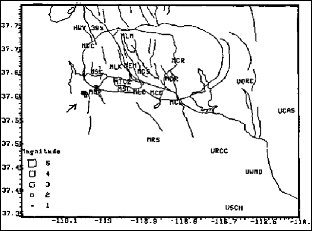 |
Figure 9. Selected epicenters for swarm events 21 May-22 September 1989 beneath Mammoth Mountain, relocated using S waves. Three- and four-letter codes mark positions of seismic stations. Courtesy of S. McNutt. |
Seismic activity remained relatively constant in July but the number of spasmodic tremor episodes increased. Bursts of spasmodic tremor with 7-13 subevents over 1-3-minute periods were detected 2 and 26 June, and 6, 13, 19, and 27 July. Seven events on 11 June, and one on 30 July had low frequencies of 1-3 Hz (probably due to attenuation effects) and poorly constrained depths of ~2 km (because no S-waves were detected). Mixed-frequency events, suggesting resonance of a fluid-filled cavity, had clear high-frequency P- and S-waves superimposed on 1-2-Hz waves, with locations similar to the high-frequency events. Stephen McNutt noted that the seismicity suggests the presence of a fluid phase (meteoric water or a volatile phase), possibly associated with magma.
During mid-late June and July, the USGS Devil's Postpile dilatometer, near the W foot of Mammoth Mountain, showed several short-term (1-10-day) fluctuations, with amplitudes of ~0.6 microstrain, superimposed on long-term extension. The regional 2-color laser network has recently shown some E-W compression in contrast to the extension of the last several years. USGS L-shaped leveling arrays on Mammoth Mountain and in the caldera's S moat showed small anomalies (possibly related to the earthquake swarm) consistent with intrusion under Mammoth Mountain. Two weak fumaroles had slightly increased temperatures and were sampled for He3/He4 analysis.
The swarm represents the highest level of seismicity near Mammoth Mountain since 1979 and has had an unusually long duration (three months); 80% of swarms analyzed by McNutt in volcanic areas worldwide have lasted less than two months. Many small events were still being recorded as of 7 August.
Geological Summary. The large 17 x 32 km Long Valley caldera east of the central Sierra Nevada Range formed as a result of the voluminous Bishop Tuff eruption about 760,000 years ago. Resurgent doming in the central part of the caldera occurred shortly afterwards, followed by rhyolitic eruptions from the caldera moat and the eruption of rhyodacite from outer ring fracture vents, ending about 50,000 years ago. During early resurgent doming the caldera was filled with a large lake that left strandlines on the caldera walls and the resurgent dome island; the lake eventually drained through the Owens River Gorge. The caldera remains thermally active, with many hot springs and fumaroles, and has had significant deformation, seismicity, and other unrest in recent years. The late-Pleistocene to Holocene Inyo Craters cut the NW topographic rim of the caldera, and along with Mammoth Mountain on the SW topographic rim, are west of the structural caldera and are chemically and tectonically distinct from the Long Valley magmatic system.
Information Contacts: S. McNutt, California Division of Mines and Geology, Sacramento; D. Hill, USGS Menlo Park.