Report on Ambrym (Vanuatu) — October 1989
Scientific Event Alert Network Bulletin, vol. 14, no. 10 (October 1989)
Managing Editor: Lindsay McClelland.
Ambrym (Vanuatu) Lava lakes in two craters; changes since 1943 described
Please cite this report as:
Global Volcanism Program, 1989. Report on Ambrym (Vanuatu) (McClelland, L., ed.). Scientific Event Alert Network Bulletin, 14:10. Smithsonian Institution. https://doi.org/10.5479/si.GVP.SEAN198910-257040
Ambrym
Vanuatu
16.25°S, 168.12°E; summit elev. 1334 m
All times are local (unless otherwise noted)
"After our previous report of the April-May 1989 eruption (14:04), activity apparently declined in early May to the normal level in the cone complex near Marum (figure 1). The previous report of a possible extra-caldera flow turned out to be erroneous, with the 1989 lava flows staying strictly confined inside the caldera. However, a pilot indicated that on 25 May a white plume was rising to 6,000 m, associated with an ash cloud that rose to 3,000 m, showing that the volcano remained active.
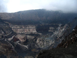
"There was no further report until two of us visited the volcano 26-30 September, gathering complementary information about the recent eruptions and the present level of activity (Monzier and Douglas, 1989). The 1988 and 1989 lava flows originated from an area on the S flank of Marum formed by one crater and two cones, one of which was already visible during a 1943 photographic survey. The flows are basaltic aa, 1-3 m thick, highly vesicular and aphyric in 1988, and slightly vesicular and plagioclase sub-aphyric in 1989. The lava contours have been mapped; one of the 1989 flows partially covered a 1988 flow, while the other (E) one rejoined the 1988 flow in the SE sector and extended farther E, but stayed inside the caldera. Observation of the main craters was limited by poor weather. The Benbow pit was occupied by a gently bubbling lava lake, evident at night by a red glow visible from Sesivi, on the S coast of Ambrym. Marum was slightly degassing. The Mbuelesu pit was also occupied by a strongly bubbling lava lake but no large explosions were observed. The crater just S of Mbuelesu was in a fumarolic stage, as were the craters from which the recent flows originated.
"The series of photographic surveys done periodically between 1943 and 1989 allows us to compare the evolution of the morphology of the craters (figure 2). Benbow, source of the major historic eruptions (figure 3), does not show any major morphological changes. In contrast, the morphology of Marum and adjacent cones changed substantially during this period. In 1943, Marum and its eastern neighbor Mbuelesu were both clogged with detrital material. Note that the small '892' cone, from which the recent flows originated, already existed in 1943. In 1953, Marum resumed its activity (Eissen, Blot, and Louat, 1991). On the 1954 photos, one new crater ('1953') underlain by fumaroles had formed across the edges of Marum and Mbuelesu Craters. Two smaller cones were also visible S of the 1953 crater. On the 1972 photos we can note: 1) the opening of a gently smoking pit in the center of Marum Crater; 2) the enlargement and division of 1953 crater, inactive at this time; 3) the formation of a new active crater S of 1953 crater, at the site of the two small cones visible in 1954. In 1986, the central pit of Marum and the W part of the 1972 double crater had merged and were slightly smoking. The E part of the 1972 double crater had enlarged at Mbuelesu and was strongly active and smoking. The 1989 situation is described above.
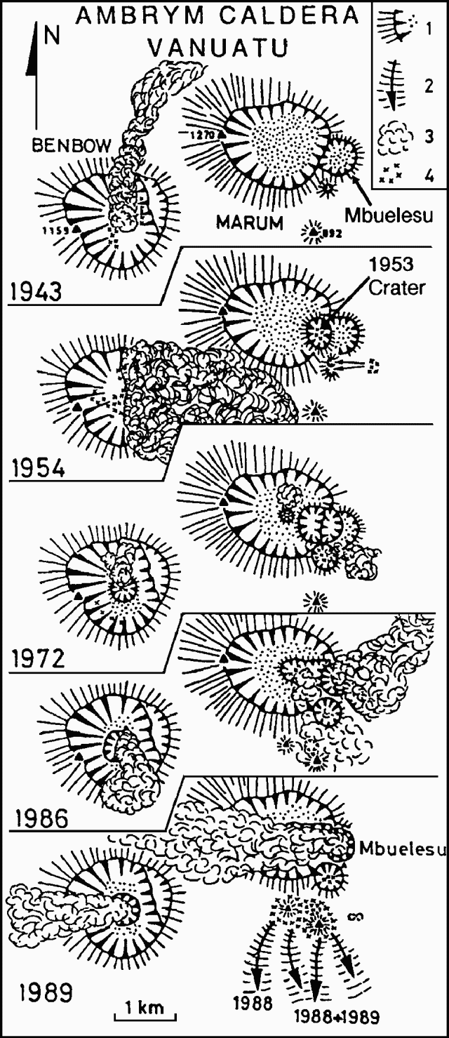 |
Figure 2. Morphological evolution of the main intra-caldera craters of Ambrym from aeriel photographic surveys done in 1943 (US Air Force), 1954 (Institut Géographique National), 4 August 1972 (Royal Air Force), and 22 September 1986 (Royal Australian Air Force), and from ground observations 27-28 September 1989 (Monzier and Douglas, 1989). Symbols: 1 = volcanic cone with detrital filling (dots); 2 = lava flow; 3 = plume (white or gray); 4 = fumaroles. |
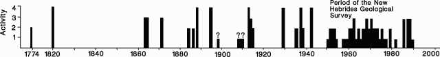 |
Figure 3. Tentative chronology of historical eruptions of Ambrym (Eissen and others, 1991). The 1774 report of activity is from Captain Cook. The 1850-1950 period is based on miscellaneous reports, mainly about extra-caldera eruptions, the only ones that are a significant threat to the local population. 1950-80 observations were by the New Hebrides Geological Survey, before Vanuatu's independence on 1 August 1980. Levels of activity: 1 = low, without precise details; 2 = high, with heavy ashfalls and/or lava lake; 3 = eruption with intra-caldera flow(s); 4 = eruption with lateral extra-caldera flows. |
"Thus, whereas Benbow has remained almost unchanged morphologically during the last 46 years, Marum and its adjacent craters strongly evolved during the same period, and recent activity seems concentrated in this area, restricted to the caldera. Although testimony is fragmental since 1980, strong activity seems to have resumed, the presence of two lava lakes indicating that the magma column is presently very high. Ambrym has had at least seven eruptions accompanied by extra-caldera lava flows, sometimes with resulting destruction and casualties. Part of the population has been evacuated several times (in 1913-15, 1929, and 1951) on adjacent islands. Careful study, observation, and eventually monitoring of this volcano should be encouraged to help prevent further destruction due to extra-caldera lava flow(s) that could reasonably be expected within the next few years."
References. Eissen, J.P., Blot, C., and Louat, R., 1991, Chronology of the historic volcanic activity of the New Hebrides Island Arc from 1595 to 1991: ORSTOM Rapports Scientifiques et Technique, Sciences de la Terre, Géologie-Géophysique, no. 2, 69 p.
Monzier, M., and Douglas, C., 1989, Rapport de Mission à Ambrym (Vanuatu) du 26 au 30 Septembre 1989: Rapport de Mission Géologie-Géophysique no. 10, Document ORSTOM Nouméa, 30 p.
New Hebrides Geological Survey, 1976, Geology of Pentecost and Ambrym: 1:100,000, Sheet 6.
Quantin, P., 1978, Archipel des Nouvelles Hébrides; Atlas des Sols et de Quelques Donées du Milieu: Cartes Pédologíques (01:50,000-1:100,000), des Formes du Relief, Géologiques et de la Végétation (01:100,000-1:250,000), 18 feuilles et 11 notices; ed. ORSTOM.
Geological Summary. Ambrym, a large basaltic volcano with a 12-km-wide caldera, is one of the most active volcanoes of the New Hebrides Arc. A thick, almost exclusively pyroclastic sequence, initially dacitic then basaltic, overlies lava flows of a pre-caldera shield volcano. The caldera was formed during a major Plinian eruption with dacitic pyroclastic flows about 1,900 years ago. Post-caldera eruptions, primarily from Marum and Benbow cones, have partially filled the caldera floor and produced lava flows that ponded on the floor or overflowed through gaps in the caldera rim. Post-caldera eruptions have also formed a series of scoria cones and maars along a fissure system oriented ENE-WSW. Eruptions have apparently occurred almost yearly during historical time from cones within the caldera or from flank vents. However, from 1850 to 1950, reporting was mostly limited to extra-caldera eruptions that would have affected local populations.
Information Contacts: J. Eissen, M. Lardy, and M. Monzier, ORSTOM, New Caledonia; C. Douglas and L. Mollard, ORSTOM, Vanuatu.