Report on Chikurachki (Russia) — 15 August-21 August 2007
Smithsonian Institution / US Geological Survey
Weekly Volcanic Activity Report, 15 August-21 August 2007
Managing Editor: Sally Sennert.
Please cite this report as:
Global Volcanism Program, 2007. Report on Chikurachki (Russia) (Sennert, S, ed.). Weekly Volcanic Activity Report, 15 August-21 August 2007. Smithsonian Institution and US Geological Survey.
Chikurachki
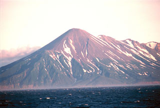
Russia
50.324°N, 155.461°E; summit elev. 1781 m
All times are local (unless otherwise noted)
Based on observations of satellite imagery, an ash plume from Chikurachki drifted about 120 km to the SE on 19 August. KVERT raised the Level of Concern Color Code from Green to Orange. The Tokyo VAAC reported that ash plumes rose to altitudes of 4.3-5.2 km (14,000-17,000 ft) a.s.l. during 20-21 August, based on observations of satellite imagery and information from KVERT.
Geological Summary. Chikurachki, the highest volcano on Paramushir Island in the northern Kuriles, is a relatively small cone constructed on a high Pleistocene edifice. Oxidized basaltic-to-andesitic scoria deposits covering the upper part of the young cone give it a distinctive red color. Frequent basaltic Plinian eruptions have occurred during the Holocene. Lava flows have reached the sea and formed capes on the NW coast; several young lava flows are also present on the E flank beneath a scoria deposit. The Tatarinov group of six volcanic centers is located immediately to the south, and the Lomonosov cinder cone group, the source of an early Holocene lava flow that reached the saddle between it and Fuss Peak to the west, lies at the southern end of the N-S-trending Chikurachki-Tatarinov complex. In contrast to the frequently active Chikurachki, the Tatarinov centers are extensively modified by erosion and have a more complex structure. Tephrochronology gives evidence of an eruption around 1690 CE from Tatarinov, although its southern cone contains a sulfur-encrusted crater with fumaroles that were active along the margin of a crater lake until 1959.
Sources: Kamchatkan Volcanic Eruption Response Team (KVERT), Tokyo Volcanic Ash Advisory Center (VAAC)