Report on Jebel at Tair (Yemen) — 3 October-9 October 2007
Smithsonian Institution / US Geological Survey
Weekly Volcanic Activity Report, 3 October-9 October 2007
Managing Editor: Sally Sennert.
Please cite this report as:
Global Volcanism Program, 2007. Report on Jebel at Tair (Yemen) (Sennert, S, ed.). Weekly Volcanic Activity Report, 3 October-9 October 2007. Smithsonian Institution and US Geological Survey.
Jebel at Tair
Yemen
15.55°N, 41.83°E; summit elev. 244 m
All times are local (unless otherwise noted)
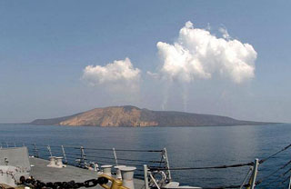
According to news reports, the eruption from the Jebel at Tair that began on 30 September continued on 3 October with lava flows noted on the W part of the island.
Geological Summary. The basaltic Jebel at Tair volcano rises from 1,200 m depth in the south-central Red Sea, forming an oval-shaped island about 3 km long. It is the northernmost known Holocene volcano in the Red Sea and lies SW of the Farisan Islands. Youthful basaltic pahoehoe lava flows from the steep-sided central vent, Jebel Duchan, cover most of the island, draping a circular cliff cut by wave erosion of an older edifice and extending beyond it to form a flat coastal plain. Pyroclastic cones are located along the NW and S coasts, and fumarolic activity occurs from two uneroded scoria cones at the summit. Radial fissures extend from the summit, some of which were the sources of lava flows. Explosive eruptions were reported in the 18th and 19th centuries, prior to an eruption in 2007-2008.
Source: Gulf News