Report on Kelud (Indonesia) — 7 November-13 November 2007
Smithsonian Institution / US Geological Survey
Weekly Volcanic Activity Report, 7 November-13 November 2007
Managing Editor: Sally Sennert.
Please cite this report as:
Global Volcanism Program, 2007. Report on Kelud (Indonesia) (Sennert, S, ed.). Weekly Volcanic Activity Report, 7 November-13 November 2007. Smithsonian Institution and US Geological Survey.
Kelud
Indonesia
7.935°S, 112.314°E; summit elev. 1730 m
All times are local (unless otherwise noted)
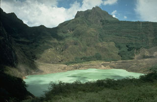
CVGHM reported that on 6 November, temperatures at the surface of Kelut's crater lake measured 75 degrees Celsius and the newly exposed lava dome surface measured 150-210 degrees Celsius. Plumes inhibited clear views of the lava dome. CVGHM lowered the Alert Status of Kelut on 8 November from 4 to 3 (on a scale of 1-4), due to a decrease in seismicity and stability indicated by deformation-monitoring instruments. CVGHM recommended that evacuees could return to their homes, but activity within a 3-km radius was restricted.
According on a news article, a volcanologist reported that the lava dome was 250 m in diameter and 120 m above the crater lake surface. On 11 November, a plume rose to an altitude of 3.7 km (12,000 ft) a.s.l. and ashfall was reported in several areas.
Geological Summary. The relatively inconspicuous Kelud stratovolcano contains a summit crater lake that has been the source of some of Indonesia's most deadly eruptions. A cluster of summit lava domes cut by numerous craters has given the summit a very irregular profile. Satellitic cones and lava domes are also located low on the E, W, and SSW flanks. Eruptive activity has in general migrated in a clockwise direction around the summit vent complex. More than 30 eruptions have been recorded since 1000 CE. The ejection of water from the crater lake during the typically short but violent eruptions has created pyroclastic flows and lahars that have caused widespread fatalities and destruction. After more than 5,000 people were killed during an eruption in 1919, an engineering project to drain the crater lake lowered the surface by more than 50 m. The 1951 eruption deepened the crater by 70 m, leaving 50 million cubic meters of water after the damaged drainage tunnels were repaired. Following more than 200 deaths in the 1966 eruption, a new deeper tunnel was constructed, and the lake's volume before the 1990 eruption was only about 1 million cubic meters.
Sources: Agence France-Presse (AFP), Pusat Vulkanologi dan Mitigasi Bencana Geologi (PVMBG, also known as CVGHM)