Report on Hunga Tonga-Hunga Ha'apai (Tonga) — 11 March-17 March 2009
Smithsonian Institution / US Geological Survey
Weekly Volcanic Activity Report, 11 March-17 March 2009
Managing Editor: Sally Sennert.
Please cite this report as:
Global Volcanism Program, 2009. Report on Hunga Tonga-Hunga Ha'apai (Tonga) (Sennert, S, ed.). Weekly Volcanic Activity Report, 11 March-17 March 2009. Smithsonian Institution and US Geological Survey.
Hunga Tonga-Hunga Ha'apai
Tonga
20.5532°S, 175.3841°W; summit elev. 114 m
All times are local (unless otherwise noted)
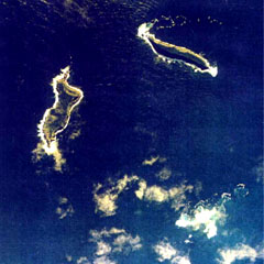
Observers flying near the area of Hunga Tonga-Hunga Ha'apai (about 62 km NNW of Nuku'alofa, the capital of Tonga) on 16 or 17 March reported seeing an eruption. Photos showed an eruption plume with a wide base that rose from the sea surface and mixed with meteorological clouds. Based on information from the Tonga airport and analysis of satellite imagery, the Wellington VAAC reported that on 18 March, a plume rose to altitudes of 4.6-7.6 km (15,000-25,000 ft) a.s.l. and drifted NE.
Geological Summary. The small andesitic islands of Hunga Tonga and Hunga Ha'apai are part of the western and northern remnants of the rim (~6 km diameter) of a largely submarine caldera located about 30 km SSE of Falcon Island. The topmost sequence of welded and unwelded ignimbrite units from a caldera-forming eruption was 14C dated to 1040-1180 CE (Cronin et al., 2017; Brenna et al. 2022). At least two additional welded pumice-rich ignimbrite units and nonwelded pyroclastic flow deposits, below paleosols and other volcaniclastic deposits, indicated more very large previous eruptions (Cronin et al., 2017; Brenna et al. 2022). Several submarine eruptions have occurred at this caldera system since the first recorded eruption in 1912, including 1937 and S of the islands in 1988. A short eruption in 2009 added land to to Hunga Ha'apai. At that time the two islands were each about 2 km long, displaying inward-facing sea cliffs with lava and tephra layers dipping gently away from the caldera. An eruption during December 2014-January 2015 was centered between the islands, and combined them into one larger structure. Major explosive eruptions in late 2021 initially reshaped the central part of the combined island before stronger activity in mid-January 2022 removed most of the 2014-15 material; an even larger eruption the next day sent an eruption plume high into the stratosphere, triggered shock waves through the atmosphere and tsunami across the Pacific Ocean, and left only small remnants of the islands above the ocean surface.
Sources: Wellington Volcanic Ash Advisory Center (VAAC), Steven Gates and Keizo Gates