Report on Eyjafjallajokull (Iceland) — 17 March-23 March 2010
Smithsonian Institution / US Geological Survey
Weekly Volcanic Activity Report, 17 March-23 March 2010
Managing Editor: Sally Sennert.
Please cite this report as:
Global Volcanism Program, 2010. Report on Eyjafjallajokull (Iceland) (Sennert, S, ed.). Weekly Volcanic Activity Report, 17 March-23 March 2010. Smithsonian Institution and US Geological Survey.
Eyjafjallajokull
Iceland
63.633°N, 19.633°W; summit elev. 1651 m
All times are local (unless otherwise noted)
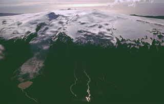
The Institute of Earth Sciences and the Icelandic Met Office reported that a fissure eruption from Eyjafjöll (also known as Eyjafjallajökull) began late at night on 20 March. High rates of deformation and increased seismic activity were noted during the previous three weeks; earthquakes were located between 7 and 10 km below the surface. During 19-20 March earthquakes migrated E and became more shallow, at 4-7 km depth. At 22:30 on 20 March seismicity slightly increased and, within the next two hours, reports of a volcanic eruption were received.
The first reports described incandescence reflected from a cloud above the eruption area, a 2-km-wide ice-free pass between Eyjafjöll and Katla volcano (with its overlying Myrdalsjökull ice cap). Lava fountains, seen from the air on 21 March, were ejected from a 500-m-long NE-SW trending fissure on the NE flank of Eyjafjöll at an elevation of about 1,000 m a.s.l. Lava flowed a short distance from the fissure and a minor plume rose 1 km and drifted W. Tephra fall was minor or insignificant. According to news articles, flights in and out of Reykjavík were diverted, delayed, or cancelled. Some local roads were closed and about 500 people living in nearby areas were evacuated. A steam explosion on 22 March generated a steam plume that rose to an altitude of 8 km (26,200 ft) a.s.l. Lava flowed S of the fissure into a canyon causing steam to rise from where the lava interacted with snow and ice. The eruption continued during 23-24 March.
Geological Summary. Eyjafjallajökull (also known as Eyjafjöll) is located west of Katla volcano. It consists of an elongated ice-covered stratovolcano with a 2.5-km-wide summit caldera. Fissure-fed lava flows occur on both the E and W flanks, but are more prominent on the western side. Although the volcano has erupted during historical time, it has been less active than other volcanoes of Iceland's eastern volcanic zone, and relatively few Holocene lava flows are known. An intrusion beneath the S flank from July-December 1999 was accompanied by increased seismic activity. The last historical activity prior to an eruption in 2010 produced intermediate-to-silicic tephra from the central caldera during December 1821 to January 1823.
Sources: Institute of Earth Sciences, Iceland Review, Iceland Review, Iceland Review, Icelandic Meteorological Office (IMO)