Report on Papandayan (Indonesia) — 24 August-30 August 2011
Smithsonian Institution / US Geological Survey
Weekly Volcanic Activity Report, 24 August-30 August 2011
Managing Editor: Sally Sennert.
Please cite this report as:
Global Volcanism Program, 2011. Report on Papandayan (Indonesia) (Sennert, S, ed.). Weekly Volcanic Activity Report, 24 August-30 August 2011. Smithsonian Institution and US Geological Survey.
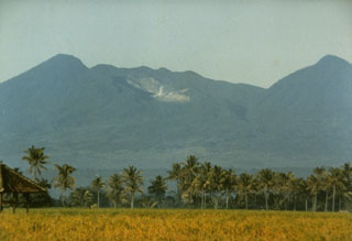
Papandayan
Indonesia
7.3175°S, 107.7306°E; summit elev. 2643 m
All times are local (unless otherwise noted)
On 26 August CVGHM reported that Papandayan showed minor to no changes in recent seismicity, deformation, geochemistry, and visual observations; therefore the Alert Level remained at 3 (on a scale of 1-4). Seismicity remained high, but stable, and was dominated by shallow volcanic earthquakes. Deformation measurements showed no change, and water temperatures in multiple fumarolic areas and lakes remained relatively unchanged. Sulfur dioxide gas emissions decreased from 8 tons per day on 12 August to 6 tons per day on 23 August. Carbon dioxide in the soil at a 1 m depth in multiple areas did not increase. Visitors and residents were advised not to venture within 2 km of the active crater.
Geological Summary. Papandayan is a complex stratovolcano at the S end of a curved volcanic massif with Kendang volcano ~9 km away at the N end, Gunung Puntang ~3.5 km NNE, and Gunung Jaya ~6 km NNE. Several episodes of collapse have created an irregular profile and produced debris avalanches that have affected lowland areas. The summit area includes four large craters, including the 1.1-km-wide, flat-floored Alun-Alun crater. A sulfur-encrusted fumarole field occupies the active Kawah Mas ("Golden Crater"). The first reported eruption, in 1772 CE, included a collapse of the NE flank and a debris avalanche that destroyed 40 villages and killed almost 3,000 people. Smaller phreatic eruptions occurred during 1923-25, 1942, and 2002.
Source: Pusat Vulkanologi dan Mitigasi Bencana Geologi (PVMBG, also known as CVGHM)