Report on Pagan (United States) — 14 August-20 August 2013
Smithsonian Institution / US Geological Survey
Weekly Volcanic Activity Report, 14 August-20 August 2013
Managing Editor: Sally Sennert.
Please cite this report as:
Global Volcanism Program, 2013. Report on Pagan (United States) (Sennert, S, ed.). Weekly Volcanic Activity Report, 14 August-20 August 2013. Smithsonian Institution and US Geological Survey.
Pagan
United States
18.13°N, 145.8°E; summit elev. 570 m
All times are local (unless otherwise noted)
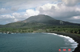
The seismic network at Pagan recorded tremor and small discrete earthquakes during 9-16 August, indicating low-level unrest. A steam-and-gas plume was visible in satellite images during periods of clear weather and from web-camera images. A small explosion with a relatively high amplitude seismic component and small infrasound component occurred at 0010 on 12 August. The data suggested that degassing increased about 30 sec after the event. The Aviation Color Code remained at Yellow and the Volcano Alert Level remained at Advisory.
Geological Summary. Pagan Island, the largest and one of the most active of the Mariana Islands volcanoes, consists of two stratovolcanoes connected by a narrow isthmus. Both North and South Pagan stratovolcanoes were constructed within calderas, 7 and 4 km in diameter, respectively. North Pagan at the NE end of the island rises above the flat floor of the northern caldera, which may have formed less than 1,000 years ago. South Pagan is a stratovolcano with an elongated summit containing four distinct craters. Almost all of the recorded eruptions, which date back to the 17th century, have originated from North Pagan. The largest eruption during historical time took place in 1981 and prompted the evacuation of the sparsely populated island.