Report on El Misti (Peru) — 18 June-24 June 2014
Smithsonian Institution / US Geological Survey
Weekly Volcanic Activity Report, 18 June-24 June 2014
Managing Editor: Sally Sennert.
Please cite this report as:
Global Volcanism Program, 2014. Report on El Misti (Peru) (Sennert, S, ed.). Weekly Volcanic Activity Report, 18 June-24 June 2014. Smithsonian Institution and US Geological Survey.
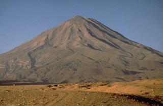
El Misti
Peru
16.2991°S, 71.4056°W; summit elev. 5793 m
All times are local (unless otherwise noted)
Instituto Geofísico del Perú (IGP) reported that, during the last 12 months, seismicity at El Misti was dominated by volcano-tectonic (VT) earthquakes. Two seismic swarms (more than 100 events per day) occurred during the last three months, on 19 May and 3 June. An increase in tremor was noted in April, although the total duration did not exceed 10 minutes and was generally low-amplitude. Long-period seismicity was not significant. In the last 15 days, seismicity increased slightly and tremor was recorded daily.
Geological Summary. El Misti is a symmetrical andesitic stratovolcano with nested summit craters immediately NE of the city of Arequipa, Peru. Eruptions from the active cone began about 13,700 and 11,300 years ago, within a 1.5 x 2 km caldera that underwent collapse about 50,000 years ago. A large scoria cone has grown with the 830-m-wide outer summit crater. At least 20 tephra-fall deposits and numerous pyroclastic-flow deposits have been documented during the past 50,000 years, including a pyroclastic flow that traveled 12 km S about 2,000 years ago. The most recent activity has been dominantly pyroclastic, and strong winds have formed a parabolic dune field of volcanic ash extending up to 20 km downwind. An eruption in the 15th century affected nearby Inca inhabitants. Some reported eruptions may represent increased fumarolic activity.