Report on Ontakesan (Japan) — 24 September-30 September 2014
Smithsonian Institution / US Geological Survey
Weekly Volcanic Activity Report, 24 September-30 September 2014
Managing Editor: Sally Sennert.
Please cite this report as:
Global Volcanism Program, 2014. Report on Ontakesan (Japan) (Sennert, S, ed.). Weekly Volcanic Activity Report, 24 September-30 September 2014. Smithsonian Institution and US Geological Survey.
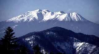
Ontakesan
Japan
35.893°N, 137.48°E; summit elev. 3067 m
All times are local (unless otherwise noted)
According to the Japan Meteorological Agency, an unexpected phreatic eruption at Ontakesan occurred at 1152 on 27 September after an 11-minute period of tremor and uplift detected just minutes beforehand. The eruption produced a pyroclastic flow that traveled more than 3 km down the S flank and an ash plume that rose 7-10 km and drifted E. Ashfall was extensive in the area and up to 50 cm thick near the craters. The Alert Level was raised to 3.
Earthquakes near the summit had temporarily increased during 10-11 September, and low-frequency signals were detected on 14 September.
News articles on 1 October noted that 47 people had died, most of them found at the summit area while others were at a slightly lower elevation. Almost 70 more people were injured. Survivors described falling ash and boulders, and being in total darkness for several minutes as they made their way down the flanks. The volcano is popular to climb and nearly 300 people were hiking on the mountain that day.
Seismicity fluctuated but remained elevated during 28 September-1 October. Ash-and-gas plumes rose 300-400 m above the craters and drifted E and SE.
Geological Summary. The massive Ontakesan stratovolcano, the second highest volcano in Japan, lies at the southern end of the Northern Japan Alps. Ascending this volcano is one of the major objects of religious pilgrimage in central Japan. It is constructed within a largely buried 4 x 5 km caldera and occupies the southern end of the Norikura volcanic zone, which extends northward to Yakedake volcano. The older volcanic complex consisted of at least four major stratovolcanoes constructed from about 680,000 to about 420,000 years ago, after which Ontakesan was inactive for more than 300,000 years. The broad, elongated summit of the younger edifice is cut by a series of small explosion craters along a NNE-trending line. Several phreatic eruptions post-date the roughly 7300-year-old Akahoya tephra from Kikai caldera. The first historical eruption took place in 1979 from fissures near the summit. A non-eruptive landslide in 1984 produced a debris avalanche and lahar that swept down valleys south and east of the volcano. Very minor phreatic activity caused a dusting of ash near the summit in 1991 and 2007. A significant phreatic explosion in September 2014, when a large number of hikers were at or near the summit, resulted in many fatalities.
Sources: Japan Meteorological Agency (JMA), Huffington Post, Huffington Post