Report on Kerinci (Indonesia) — 6 March-12 March 2019
Smithsonian Institution / US Geological Survey
Weekly Volcanic Activity Report, 6 March-12 March 2019
Managing Editor: Sally Sennert.
Please cite this report as:
Global Volcanism Program, 2019. Report on Kerinci (Indonesia) (Sennert, S, ed.). Weekly Volcanic Activity Report, 6 March-12 March 2019. Smithsonian Institution and US Geological Survey.
Kerinci
Indonesia
1.697°S, 101.264°E; summit elev. 3800 m
All times are local (unless otherwise noted)
PVMBG reported that at 1850 on 7 March a brown ash emission rose 150 m above the rim of Kerinci summit vent and drifted NE. Ash also drifted down the SE and E flanks. Another brown ash emission was observed at 1209 on 8 March rising 700 m and drifting W. Brown ash emissions at 1607 on 10 March and 0919 on 11 March rose 300 m and 500 m, respectively, and drifted NE. Seismicity was dominated by volcanic tremor during 7-11 March.
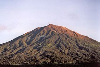
Geological Summary. Gunung Kerinci in central Sumatra forms Indonesia's highest volcano and is one of the most active in Sumatra. It is capped by an unvegetated young summit cone that was constructed NE of an older crater remnant. There is a deep 600-m-wide summit crater often partially filled by a small crater lake that lies on the NE crater floor, opposite the SW-rim summit. The massive 13 x 25 km wide volcano towers 2400-3300 m above surrounding plains and is elongated in a N-S direction. Frequently active, Kerinci has been the source of numerous moderate explosive eruptions since its first recorded eruption in 1838.
Source: Pusat Vulkanologi dan Mitigasi Bencana Geologi (PVMBG, also known as CVGHM)