Report on Aniakchak (United States) — 25 October-31 October 2023
Smithsonian Institution / US Geological Survey
Weekly Volcanic Activity Report, 25 October-31 October 2023
Managing Editor: Sally Sennert.
Please cite this report as:
Global Volcanism Program, 2023. Report on Aniakchak (United States) (Sennert, S, ed.). Weekly Volcanic Activity Report, 25 October-31 October 2023. Smithsonian Institution and US Geological Survey.
Aniakchak
United States
56.88°N, 158.17°W; summit elev. 1341 m
All times are local (unless otherwise noted)
AVO reported that on 26 October strong winds in areas NW of Aniakchak and E of Port Heiden dispersed unconsolidated ash up to 0.9 km (3,000 ft) a.s.l. to the NW. The ash cloud was visible in satellite images and in Port Heiden webcam views. The Volcano Alert Level remained at Normal (the lowest level on a four-level scale) and the Aviation Color Code remained at Green (the lowest level on a four-color scale). Equipment failed on 30 October, so AVO could no longer seismically monitor the volcano at an adequate level and determine if activity was at a typical background level. Both the Volcano Alert Level and the Aviation Color Code were changed to Unassigned.
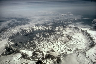
Geological Summary. One of the most dramatic calderas of the Aleutian arc, the 10-km-wide Aniakchak caldera formed around 3,400 years ago during a voluminous eruption in which pyroclastic flows traveled more than 50 km N to the Bering Sea and also reached the Pacific Ocean to the south. At least 40 explosive eruptions have been documented during the past 10,000 years, making it the most active volcano of the eastern Aleutian arc. A dominantly andesitic pre-caldera volcano was constructed above basement Mesozoic and Tertiary sedimentary rocks that are exposed in the caldera walls to elevations of about 610 m. The ice-free caldera floor contains many pyroclastic cones, tuff cones, maars, and lava domes. Surprise Lake on the NE side drains through The Gates, a steep-walled breach on the east side of the 1-km-high caldera rim that was the site of catastrophic draining of a once larger lake about 1850 years BP. Vent Mountain and Half Cone are two long-lived vents on the south-central and NW caldera floor, respectively. The first and only confirmed historical eruption took place in 1931 from vents on the west and SW caldera floor.
Source: US Geological Survey Alaska Volcano Observatory (AVO)