Report on Brava (Cabo Verde) — 22 November-28 November 2023
Smithsonian Institution / US Geological Survey
Weekly Volcanic Activity Report, 22 November-28 November 2023
Managing Editor: Sally Sennert.
Please cite this report as:
Global Volcanism Program, 2023. Report on Brava (Cabo Verde) (Sennert, S, ed.). Weekly Volcanic Activity Report, 22 November-28 November 2023. Smithsonian Institution and US Geological Survey.
Brava
Cabo Verde
14.8514°N, 24.7041°W; summit elev. 956 m
All times are local (unless otherwise noted)
According to the Cape Verde National Institute of Meteorology and Geophysics (INMG), seismicity at Brava increased on 30 October and remained elevated. A M 3.6 earthquake was recorded at 1819 on 30 October and was followed by eight more events of similar magnitudes that were felt by residents. A M 4.8 was recorded at 2100 and was followed by a 48-hour-long seismic swarm mostly consisting of low-magnitude events that were unable to be located. The Alert Level was raised to 2 (the second level on a five-level scale) on 30 October.
The rate of seismicity was variable, with two events every 1-10 minutes during 30 October-1 November. Most of the events were located at depths of 3-4 km; the hypocenters were initially located in the Praia de Águada area but then they migrated towards the center of the island. Continuous harmonic tremor emerged on 9 November and was interpreted as indicating the movement of magmatic gases. On 15 November seismicity increased and was characterized by more intense periods of volcanic tremor, long-period events, and “burst” events defined as identical events separated by a few seconds. In addition, residents began to feel earthquakes more often. The Alert Level was raised to 3. Three earthquakes all with magnitudes greater than three occurred during 18-19 November, and harmonic tremor again intensified on 19 November.
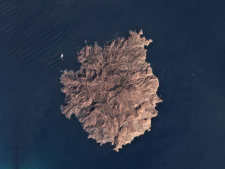
Geological Summary. Brava Island, 18 km W of Fogo, is the westernmost of the southern Cape Verde islands. The 10-km-wide island contains 15 morphologically youthful craters located along two or three lineaments intersecting along the crest of the island. Most of the younger eruptions originated from the interaction of phonolitic magmas with a large groundwater reservoir contained within an older volcanic series characterized by thick welded ignimbrites and block-and-ash flow deposits. Carbonatitic lavas are also found.
Sources: Instituto Nacional de Meteorologia e Geofísica (INMG), Governo de Cabo Verde