Thermal alerts indicate possible activity during August-October 2002
Thermal alerts detected by MODIS within the 2001-2002 period occurred only during August-October 2002 (figure 3) in the summit area. The first alert occurred on 13 August 2002 when a single alert-pixel had an alert ratio of -0.542. On 10 October the anomaly consisted of two alert-pixels with a maximum alert ratio of -0.409, and on 21 October the anomaly was characterized by six alert-pixels (clustered SW of the summit) with a maximum alert ratio of -0.571.
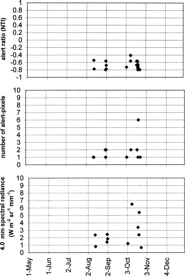 |
Figure 3. MODIS-detected alerts on Arjuno-Welirang during May-December 2002. Thermal alerts collated by Diego Coppola and David Rothery; data courtesy of the Hawaii Institute of Geophysics and Planetology's MODIS Thermal Alert Team. |
The Volcanological Survey of Indonesia reported that the volcano was at Status Level I (no activity) in October 2002. No observations were reported, but only distant tectonic earthquakes were detected at the seismograph station.
An explosive eruption took place in the NW part of Gunung Welirang in October 1950, and eruptive activity was reported on the NW flank (Kawah Plupuh) in August 1952. Steam plumes from the summit of Welirang were photographed from space on 13 September 1991 (BGVN 16:08) and in mid-November 1994.
Information Contacts: Dali Ahmad, Volcanological Survey of Indonesia (VSI), Jalan Diponegoro No. 57, Bandung 40122, Indonesia (URL: http://www.vsi.esdm.go.id/); Diego Coppola and David A. Rothery, Department of Earth Sciences, The Open University, Milton Keynes, MK7 6AA, UK. Thermal alerts courtesy of the HIGP MODIS Thermal Alerts Team (URL: http://modis.higp.hawaii.edu/).
The Global Volcanism Program has no Weekly Reports available for Arjuno-Welirang.
Reports are organized chronologically and indexed below by Month/Year (Publication Volume:Number), and include a one-line summary. Click on the index link or scroll down to read the reports.
White plume from Welirang summit
A plume from the summit area of Welirang . . . was photographed by Space Shuttle astronauts on 13 September at [1535] (photo no. S48-151-064) (figure 1). The dense portion of the apparently ash-poor plume extended roughly 50 km N and more diffuse material continued for another 65 km. The summit area was white and apparently de-vegetated. A plume was observed again on direct video downlink from the spacecraft on [17] September at [1306]. No ground reports were available at press time.
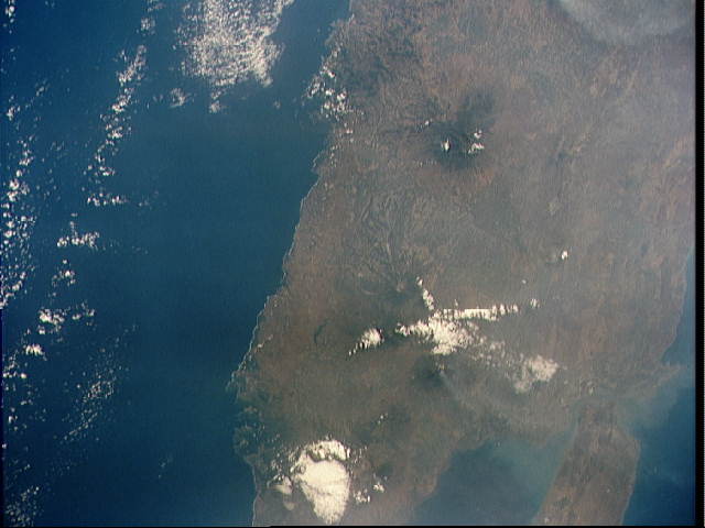 |
Figure 1. Space Shuttle photograph showing a steam plume from Welirang (just east of the central cloud mass). Also, the lack of vegetation at the peak indicates volcanic activity. Volcanoes on Java form an E-W line of peaks the length of the island; five are in this image. NASA Photo ID: STS048-151-064, 13 September 1991. |
Information Contacts: C. Evans and D. Helms, NASA-SSEOP.
Steam plume in mid-November seen from space
A photograph taken from the Space Shuttle in mid-November 1994 showed a possible steam plume originating from the summit of Arjuno (figure 2).
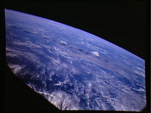 |
Figure 2. This is a striking, oblique view to the south of the Indonesian islands of Java (right), Bali and Lombok (upper left). The linear array of dark regions across the photo is a chain of volcanoes. Plumes of steam can be seen rising from the summits of Arjuno (eastern Java, near the center of the photo) and Merapi (central Java, near the right of the photo). The region appears hazy due to an extended drought over Indonesia, New Guinea, and Australia resulting in huge fires and a regional smoke pall. NASA Photo ID: STS066-154-157. Approximate date: 14 November 1994. |
Information Contacts: NASA JSC Digital Image Collection (URL: http://images.jsc.nasa.gov/).
Thermal alerts indicate possible activity during August-October 2002
Thermal alerts detected by MODIS within the 2001-2002 period occurred only during August-October 2002 (figure 3) in the summit area. The first alert occurred on 13 August 2002 when a single alert-pixel had an alert ratio of -0.542. On 10 October the anomaly consisted of two alert-pixels with a maximum alert ratio of -0.409, and on 21 October the anomaly was characterized by six alert-pixels (clustered SW of the summit) with a maximum alert ratio of -0.571.
|
Figure 3. MODIS-detected alerts on Arjuno-Welirang during May-December 2002. Thermal alerts collated by Diego Coppola and David Rothery; data courtesy of the Hawaii Institute of Geophysics and Planetology's MODIS Thermal Alert Team. |
The Volcanological Survey of Indonesia reported that the volcano was at Status Level I (no activity) in October 2002. No observations were reported, but only distant tectonic earthquakes were detected at the seismograph station.
An explosive eruption took place in the NW part of Gunung Welirang in October 1950, and eruptive activity was reported on the NW flank (Kawah Plupuh) in August 1952. Steam plumes from the summit of Welirang were photographed from space on 13 September 1991 (BGVN 16:08) and in mid-November 1994.
Information Contacts: Dali Ahmad, Volcanological Survey of Indonesia (VSI), Jalan Diponegoro No. 57, Bandung 40122, Indonesia (URL: http://www.vsi.esdm.go.id/); Diego Coppola and David A. Rothery, Department of Earth Sciences, The Open University, Milton Keynes, MK7 6AA, UK. Thermal alerts courtesy of the HIGP MODIS Thermal Alerts Team (URL: http://modis.higp.hawaii.edu/).
|
|
||||||||||||||||||||||||||
There is data available for 2 confirmed eruptive periods.
[ 1991 Sep 13 ] Uncertain Eruption
| Episode 1 | Eruption (Explosive / Effusive) | Gunung Welirang | |||||||||||||
|---|---|---|---|---|---|---|---|---|---|---|---|---|---|---|
| 1991 Sep 13 - Unknown | Evidence from Unknown | |||||||||||||
|
List of 1 Events for Episode 1 at Gunung Welirang
|
||||||||||||||
1952 Aug 15 ± 5 days Confirmed Eruption (Explosive / Effusive) VEI: 0
| Episode 1 | Eruption (Explosive / Effusive) | NW flank (Kawah Plupuh) | ||||||||||||||||||||||||||||
|---|---|---|---|---|---|---|---|---|---|---|---|---|---|---|---|---|---|---|---|---|---|---|---|---|---|---|---|---|---|
| 1952 Aug 15 ± 5 days - Unknown | Evidence from Observations: Reported | ||||||||||||||||||||||||||||
|
List of 4 Events for Episode 1 at NW flank (Kawah Plupuh)
|
|||||||||||||||||||||||||||||
1950 Oct 30 Confirmed Eruption (Explosive / Effusive) VEI: 2
| Episode 1 | Eruption (Explosive / Effusive) | NW part of Gunung Welirang (2500 & 2700 m) | |||||||||||||||||||||||
|---|---|---|---|---|---|---|---|---|---|---|---|---|---|---|---|---|---|---|---|---|---|---|---|---|
| 1950 Oct 30 - Unknown | Evidence from Observations: Reported | |||||||||||||||||||||||
|
List of 3 Events for Episode 1 at NW part of Gunung Welirang (2500 & 2700 m)
|
||||||||||||||||||||||||
This compilation of synonyms and subsidiary features may not be comprehensive. Features are organized into four major categories: Cones, Craters, Domes, and Thermal Features. Synonyms of features appear indented below the primary name. In some cases additional feature type, elevation, or location details are provided.
Cones |
||||
| Feature Name | Feature Type | Elevation | Latitude | Longitude |
| Andjasmoro | Stratovolcano | 2290 m | 7° 45' 13.00" S | 112° 30' 27.00" E |
| Arjuno
Ardjoeno Widodaren |
Stratovolcano | 3343 m | 7° 45' 55.00" S | 112° 35' 25.00" E |
| Bakal | Cone - Crater | 2985 m | ||
| Budugasu, Gunung
Boedoegasoe, Gunung |
Cone | |||
| Butak, Gunung
Boetak, Gunung |
Cone | 1208 m | ||
| Gebug, Gunung
Geboeg, Gunung |
Cone | 951 m | ||
| Kembar Dua
Kembar South |
Cone - Crater | 3122 m | 7° 45' 1.00" S | 112° 34' 53.00" E |
| Kembar Satu
Kembar North |
Cone - Crater | 3040 m | 7° 44' 36.00" S | 112° 34' 44.00" E |
| Kembar, Gunung | Cone | 1270 m | ||
| Mungker, Gunung
Moengker, Gunung |
Cone | |||
| Papa, Gunung | Cone | 1467 m | ||
| Pundak, Gunung
Poendak, Gunung |
Cone | 1551 m | ||
| Ringgit, Gunung | Stratovolcano | 2481 m | 7° 44' 24.00" S | 112° 36' 51.00" E |
| Wedon, Gunung | Cone | 659 m | ||
| Welirang | Stratovolcano | 3151 m | 7° 43' 52.00" S | 112° 34' 29.00" E |
Craters |
||||
| Feature Name | Feature Type | Elevation | Latitude | Longitude |
| Jero
Djero |
Crater | 3107 m | 7° 44' 7.00" S | 112° 34' 31.00" E |
| Mati | Crater | |||
| Plupuh, Kawah | Crater | 3086 m | 7° 44' 6.00" S | 112° 34' 37.00" E |
| Sumur Bandung | Crater | |||
| Tilas Geni | Crater | 3104 m | 7° 44' 7.00" S | 112° 34' 33.00" E |
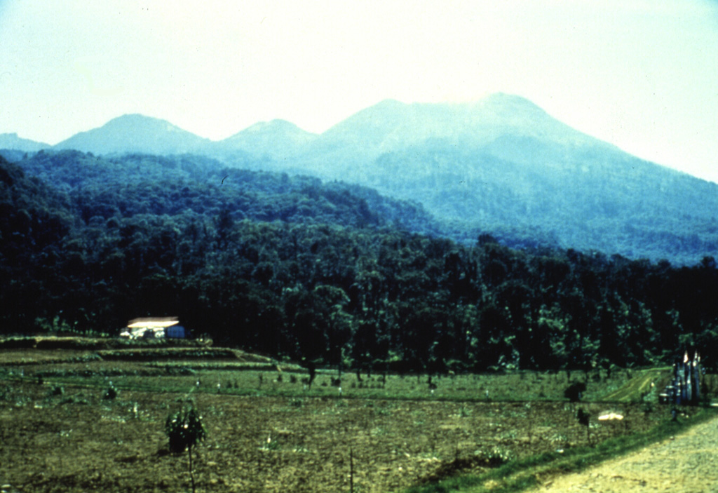
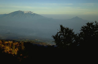 The Arjuno-Welirang volcanic complex (left) and the smaller Gunung Penanggungan volcano (right) are seen here from the SE across a broad valley from the summit of Tengger caldera. A chain of small cones and craters extends across the Arjuno-Welirang complex, while the flanks of the small Penanggungan stratovolcano contain lava flows from flank vents.
 The volcanoes of Arjuno (right-center) and Welirang (left) are seen here NE of cultivated land. A line of cones have formed across the southern flank of Gunung Arjuno and extends to its eastern flank. Fumarolic areas with sulfur deposition occur at several locations on Gunung Welirang.
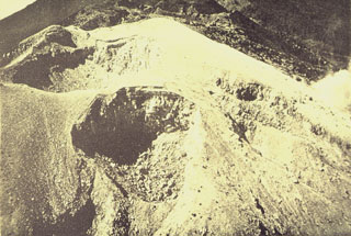 A complex cluster of craters at the summit of Gunung Welirang. Kawah Jero crater (upper left) lies behind Tilas Geni crater in the foreground, and Kawah Plupuh is to the right. This view looks from the north to craters of Gunung Arjuno in the background.
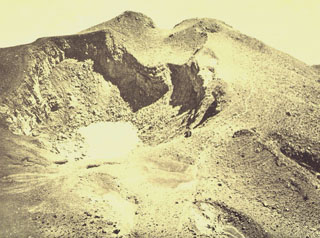 Kawah Jero is one of several craters along the summit of Gunung Welirang, the northernmost section of the Arjuno-Welirang stratovolcanoes. A 6-km-long chain of cones and craters extends NW-SE between the volcanoes.
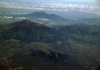 Three young volcanoes in eastern Java are seen in this aerial view from the NE. The Arjuno-Welirang massif lies at the left-center, with Gunung Arjuno forming the high point of the complex and light-colored Gunung Welirang to the NW (right). In the background is the Kawi-Butak massif, with Gunung Butak forming the high point and Gunung Kawi to its right. The smaller conical peak of Penanggungan rises above lowlands in the foreground.
There are no samples for Arjuno-Welirang in the Smithsonian's NMNH Department of Mineral Sciences Rock and Ore collection.
| Copernicus Browser | The Copernicus Browser replaced the Sentinel Hub Playground browser in 2023, to provide access to Earth observation archives from the Copernicus Data Space Ecosystem, the main distribution platform for data from the EU Copernicus missions. |
| MIROVA | Middle InfraRed Observation of Volcanic Activity (MIROVA) is a near real time volcanic hot-spot detection system based on the analysis of MODIS (Moderate Resolution Imaging Spectroradiometer) data. In particular, MIROVA uses the Middle InfraRed Radiation (MIR), measured over target volcanoes, in order to detect, locate and measure the heat radiation sourced from volcanic activity. |
| MODVOLC Thermal Alerts | Using infrared satellite Moderate Resolution Imaging Spectroradiometer (MODIS) data, scientists at the Hawai'i Institute of Geophysics and Planetology, University of Hawai'i, developed an automated system called MODVOLC to map thermal hot-spots in near real time. For each MODIS image, the algorithm automatically scans each 1 km pixel within it to check for high-temperature hot-spots. When one is found the date, time, location, and intensity are recorded. MODIS looks at every square km of the Earth every 48 hours, once during the day and once during the night, and the presence of two MODIS sensors in space allows at least four hot-spot observations every two days. Each day updated global maps are compiled to display the locations of all hot spots detected in the previous 24 hours. There is a drop-down list with volcano names which allow users to 'zoom-in' and examine the distribution of hot-spots at a variety of spatial scales. |
|
WOVOdat
Single Volcano View Temporal Evolution of Unrest Side by Side Volcanoes |
WOVOdat is a database of volcanic unrest; instrumentally and visually recorded changes in seismicity, ground deformation, gas emission, and other parameters from their normal baselines. It is sponsored by the World Organization of Volcano Observatories (WOVO) and presently hosted at the Earth Observatory of Singapore.
GVMID Data on Volcano Monitoring Infrastructure The Global Volcano Monitoring Infrastructure Database GVMID, is aimed at documenting and improving capabilities of volcano monitoring from the ground and space. GVMID should provide a snapshot and baseline view of the techniques and instrumentation that are in place at various volcanoes, which can be use by volcano observatories as reference to setup new monitoring system or improving networks at a specific volcano. These data will allow identification of what monitoring gaps exist, which can be then targeted by remote sensing infrastructure and future instrument deployments. |
| Volcanic Hazard Maps | The IAVCEI Commission on Volcanic Hazards and Risk has a Volcanic Hazard Maps database designed to serve as a resource for hazard mappers (or other interested parties) to explore how common issues in hazard map development have been addressed at different volcanoes, in different countries, for different hazards, and for different intended audiences. In addition to the comprehensive, searchable Volcanic Hazard Maps Database, this website contains information about diversity of volcanic hazard maps, illustrated using examples from the database. This site is for educational purposes related to volcanic hazard maps. Hazard maps found on this website should not be used for emergency purposes. For the most recent, official hazard map for a particular volcano, please seek out the proper institutional authorities on the matter. |
| IRIS seismic stations/networks | Incorporated Research Institutions for Seismology (IRIS) Data Services map showing the location of seismic stations from all available networks (permanent or temporary) within a radius of 0.18° (about 20 km at mid-latitudes) from the given location of Arjuno-Welirang. Users can customize a variety of filters and options in the left panel. Note that if there are no stations are known the map will default to show the entire world with a "No data matched request" error notice. |
| UNAVCO GPS/GNSS stations | Geodetic Data Services map from UNAVCO showing the location of GPS/GNSS stations from all available networks (permanent or temporary) within a radius of 20 km from the given location of Arjuno-Welirang. Users can customize the data search based on station or network names, location, and time window. Requires Adobe Flash Player. |
| DECADE Data | The DECADE portal, still in the developmental stage, serves as an example of the proposed interoperability between The Smithsonian Institution's Global Volcanism Program, the Mapping Gas Emissions (MaGa) Database, and the EarthChem Geochemical Portal. The Deep Earth Carbon Degassing (DECADE) initiative seeks to use new and established technologies to determine accurate global fluxes of volcanic CO2 to the atmosphere, but installing CO2 monitoring networks on 20 of the world's 150 most actively degassing volcanoes. The group uses related laboratory-based studies (direct gas sampling and analysis, melt inclusions) to provide new data for direct degassing of deep earth carbon to the atmosphere. |
| Large Eruptions of Arjuno-Welirang | Information about large Quaternary eruptions (VEI >= 4) is cataloged in the Large Magnitude Explosive Volcanic Eruptions (LaMEVE) database of the Volcano Global Risk Identification and Analysis Project (VOGRIPA). |
| EarthChem | EarthChem develops and maintains databases, software, and services that support the preservation, discovery, access and analysis of geochemical data, and facilitate their integration with the broad array of other available earth science parameters. EarthChem is operated by a joint team of disciplinary scientists, data scientists, data managers and information technology developers who are part of the NSF-funded data facility Integrated Earth Data Applications (IEDA). IEDA is a collaborative effort of EarthChem and the Marine Geoscience Data System (MGDS). |

