The Global Volcanism Program has no activity reports available for Potato Butte.
The Global Volcanism Program has no Weekly Reports available for Potato Butte.
The Global Volcanism Program has no Bulletin Reports available for Potato Butte.
|
|
||||||||||||||||||
The Global Volcanism Program is not aware of any Holocene eruptions from Potato Butte. If this volcano has had large eruptions (VEI >= 4) prior to 12,000 years ago, information might be found on the Potato Butte page in the LaMEVE (Large Magnitude Explosive Volcanic Eruptions) database, a part of the Volcano Global Risk Identification and Analysis Project (VOGRIPA).
This compilation of synonyms and subsidiary features may not be comprehensive. Features are organized into four major categories: Cones, Craters, Domes, and Thermal Features. Synonyms of features appear indented below the primary name. In some cases additional feature type, elevation, or location details are provided.
Cones |
||||
| Feature Name | Feature Type | Elevation | Latitude | Longitude |
| Little Potato Butte | Pyroclastic cone | 1463 m | 40° 39' 0.00" N | 121° 26' 0.00" W |
| Sugarloaf Peak | Shield volcano | 1997 m | 40° 42' 0.00" N | 121° 28' 0.00" W |
Craters |
||||
| Feature Name | Feature Type | Elevation | Latitude | Longitude |
| Hat Creek | Fissure vent | 1370 m | 40° 38' 0.00" N | 121° 25' 0.00" W |
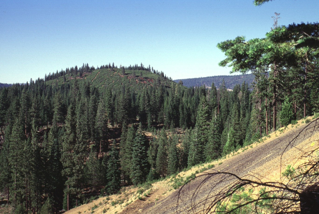
 Potato Butte, the forested cinder cone at the left-center, is seen here from the rim of the Hat Creek vent with snow-covered Lassen Peak in the background. The Potato Butte cinder cones and lava flows were erupted around 65,000-75,000 years ago. The prominent 30,000-year-old Hat Creek lava flow traveled nearly 30 km from a fissure vent near the town of Old Station. An undated, but younger-looking flow originated from a cinder cone near West Prospect Peak, west of Potato Butte.
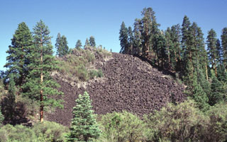 This steep-sided blocky lava flow originated from Potato Butte, twin cinder cones located immediately north of Lassen Volcanic National Park. The lava flows originated from vents that overlie the western side of the Hat Creek valley and traveled primarily to the north and west of the cones. The flows, once thought to be of possible Holocene age, have been dated at 65,000-75,000 years old.
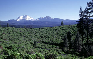 The green Manzanita-covered slope in the foreground is part of the circular rim of South Potato Butte, one of two cinder cones forming Potato Butte. The two cinder cones fed youthful-looking lava flows down the Hat Creek graben. Snow-covered Lassen Peak rises in the distance, with the Chaos Crags lava dome complex to its right.
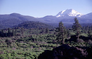
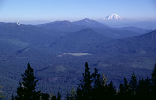 The two small Pleistocene cinder cones in the Hat Creek valley, just to the right of the two highest trees in the foreground, are viewed here from West Prospect Peak. The cones are among a series of young volcanic vents located north of Lassen Peak and fed lava flows that traveled to the north (right). Three forest-covered Pleistocene volcanoes can be seen in the background, Sugarloaf (above the green meadow in the center), Logan Mountain (left-center), and Burney Mountain (right-center). Snow-capped Mount Shasta is at the upper right.
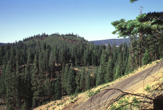 North Potato Butte, seen here from South Potato Butte, is a 65,000-75,000-year-old cinder cone located in the Hat Creek valley north of Lassen Peak. The Potato Butte cinder cones are among a series of small Quaternary basaltic volcanic vents located between Lassen and Medicine Lake volcanoes.
There are no samples for Potato Butte in the Smithsonian's NMNH Department of Mineral Sciences Rock and Ore collection.
| Copernicus Browser | The Copernicus Browser replaced the Sentinel Hub Playground browser in 2023, to provide access to Earth observation archives from the Copernicus Data Space Ecosystem, the main distribution platform for data from the EU Copernicus missions. |
|
WOVOdat
Single Volcano View Temporal Evolution of Unrest Side by Side Volcanoes |
WOVOdat is a database of volcanic unrest; instrumentally and visually recorded changes in seismicity, ground deformation, gas emission, and other parameters from their normal baselines. It is sponsored by the World Organization of Volcano Observatories (WOVO) and presently hosted at the Earth Observatory of Singapore.
GVMID Data on Volcano Monitoring Infrastructure The Global Volcano Monitoring Infrastructure Database GVMID, is aimed at documenting and improving capabilities of volcano monitoring from the ground and space. GVMID should provide a snapshot and baseline view of the techniques and instrumentation that are in place at various volcanoes, which can be use by volcano observatories as reference to setup new monitoring system or improving networks at a specific volcano. These data will allow identification of what monitoring gaps exist, which can be then targeted by remote sensing infrastructure and future instrument deployments. |
| IRIS seismic stations/networks | Incorporated Research Institutions for Seismology (IRIS) Data Services map showing the location of seismic stations from all available networks (permanent or temporary) within a radius of 0.18° (about 20 km at mid-latitudes) from the given location of Potato Butte. Users can customize a variety of filters and options in the left panel. Note that if there are no stations are known the map will default to show the entire world with a "No data matched request" error notice. |
| UNAVCO GPS/GNSS stations | Geodetic Data Services map from UNAVCO showing the location of GPS/GNSS stations from all available networks (permanent or temporary) within a radius of 20 km from the given location of Potato Butte. Users can customize the data search based on station or network names, location, and time window. Requires Adobe Flash Player. |
| Large Eruptions of Potato Butte | Information about large Quaternary eruptions (VEI >= 4) is cataloged in the Large Magnitude Explosive Volcanic Eruptions (LaMEVE) database of the Volcano Global Risk Identification and Analysis Project (VOGRIPA). |
| EarthChem | EarthChem develops and maintains databases, software, and services that support the preservation, discovery, access and analysis of geochemical data, and facilitate their integration with the broad array of other available earth science parameters. EarthChem is operated by a joint team of disciplinary scientists, data scientists, data managers and information technology developers who are part of the NSF-funded data facility Integrated Earth Data Applications (IEDA). IEDA is a collaborative effort of EarthChem and the Marine Geoscience Data System (MGDS). |

