The Global Volcanism Program has no activity reports available for Isla Isabel.
The Global Volcanism Program has no Weekly Reports available for Isla Isabel.
The Global Volcanism Program has no Bulletin Reports available for Isla Isabel.
|
|
||||||||||||||||||||||
The Global Volcanism Program is not aware of any Holocene eruptions from Isla Isabel. If this volcano has had large eruptions (VEI >= 4) prior to 12,000 years ago, information might be found on the Isla Isabel page in the LaMEVE (Large Magnitude Explosive Volcanic Eruptions) database, a part of the Volcano Global Risk Identification and Analysis Project (VOGRIPA).
This compilation of synonyms and subsidiary features may not be comprehensive. Features are organized into four major categories: Cones, Craters, Domes, and Thermal Features. Synonyms of features appear indented below the primary name. In some cases additional feature type, elevation, or location details are provided.
Cones |
||||
| Feature Name | Feature Type | Elevation | Latitude | Longitude |
| Acantilados Mayor | Tuff cone | |||
| Acantilados Rabijuncos | Tuff cone | |||
| Faro, Cerro el | Tuff cone | |||
| Mirador, Cerro del | Tuff cone | 95 m | ||
| Pelicanos, Cerro de los | Tuff cone | |||
| Transverso, Monte | Tuff cone | |||
Craters |
||||
| Feature Name | Feature Type | Elevation | Latitude | Longitude |
| Fragatas, Lagunas | Maar | |||
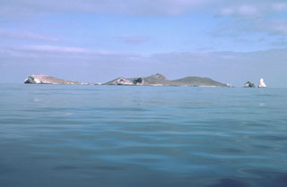 Isla Isabel, a complex of cones and associated lava flows, forms a small 1.5-km-long island located in the Pacific Ocean 30 km off the coast of Nayarit state, Mexico. The island is seen here from the SE with Cerro el Faro cone to the left and the spires of the Islotes Las Monas to the right. Isla Isabel is a wildlife sanctuary whose rocks and vegetation are mantled with white guano. Exposures of the interior of the cones forming the island can be seen in the main island sea cliffs and offshore islets.
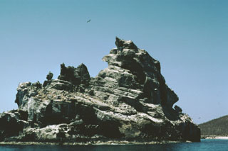 Wave erosion of a tuff cone off the western coast of Isla Isabel has produced the jagged profile of the 100-m-wide southernmost sea stack in the Islotes Las Monas. The three guano-covered cone remnants forming the Islotes Las Monas lie within about 200 m of the eastern coast of Isla Isabel, which can be seen to the right.
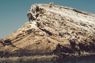 A sea-cliff exposure at the southern end of Islota Pelón, located off the NW coast of Isla Isabel, shows a dramatic angular uncomformity between two generations of dipping tuff beds. The large volcanic bomb perched on the rim at the top lies on dipping layers in the interior of the tuff cone. Wave erosion has left only the arcuate western rim of Islota Pelón, whose vent lies out of view to the right.
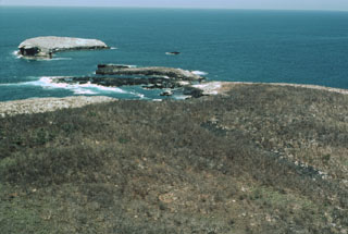 Islota Pelón (upper left), just off the NW coast of Isla Isabel, is the outer rim of a mostly submerged cone whose SE rim (center) is located on the tip of the main island. A narrow lava flow seen diagonally from the lower right to the bay is part of the Planicie lava flow and is the product of the youngest eruption on Isla Isabel.
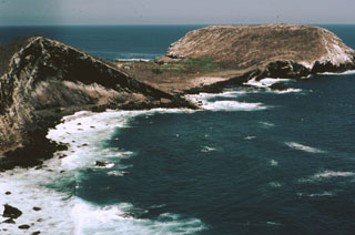 The flat-topped Cerro El Faro cone (upper right) lies across a low isthmus at the southernmost tip of Isla Isabel. It is seen here across the Acantilado Mayor Bay from Cerro del Mirador, the high point of the small 1.5-km-long island. Wave erosion has eroded the flank of Monte Transverso to the left. The two cones are connected by a lava flow.
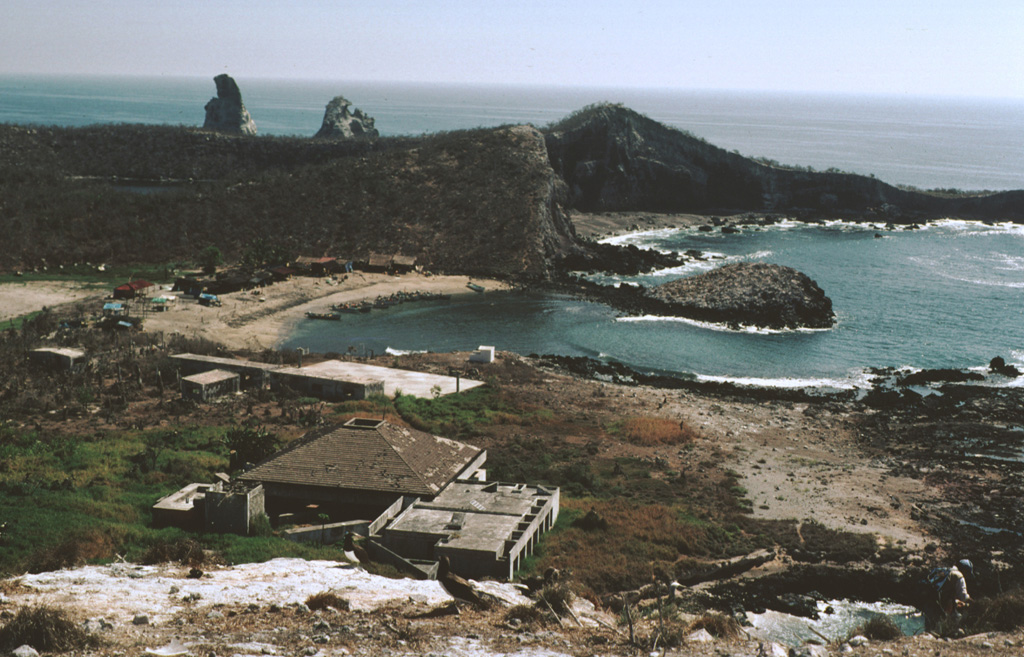
 A biological research station and fishermen's shacks line the shores of Playa Chica on the SE side of Isla Isabel in this 1999 photo. The two spires to the upper left are the Islotes Las Monas, eroded remnants of an offshore cone. The lake-filled Laguna Fragatas maar can be seen at the left in front of the spires of the Islotes Las Monas. The small 1.5-km-wide uninhabited Isla Isabel is a wildlife sanctuary.
The following 46 samples associated with this volcano can be found in the Smithsonian's NMNH Department of Mineral Sciences collections, and may be availble for research (contact the Rock and Ore Collections Manager). Catalog number links will open a window with more information.
| Catalog Number | Sample Description | Lava Source | Collection Date |
|---|---|---|---|
| NMNH 117623-1 | Scoria | -- | -- |
| NMNH 117623-10 | Dunite Xenolith | -- | -- |
| NMNH 117623-11 | Peridotite Xenolith | -- | -- |
| NMNH 117623-12 | Basalt | -- | -- |
| NMNH 117623-13 | Basalt | -- | -- |
| NMNH 117623-14 | Basalt | -- | -- |
| NMNH 117623-15 | Scoria | -- | -- |
| NMNH 117623-16 | Harzburgite Xenolith | -- | -- |
| NMNH 117623-17 | Peridotite Xenolith | -- | -- |
| NMNH 117623-18 | Peridotite Xenolith | -- | -- |
| NMNH 117623-19 | Gabbro | -- | -- |
| NMNH 117623-2 | Trachybasalt | -- | -- |
| NMNH 117623-20 | Peridotite Xenolith | -- | -- |
| NMNH 117623-21 | Harzburgite Xenolith | -- | -- |
| NMNH 117623-22 | Harzburgite Xenolith | -- | -- |
| NMNH 117623-23 | Harzburgite Xenolith | -- | -- |
| NMNH 117623-24 | Peridotite Xenolith | -- | -- |
| NMNH 117623-25 | Peridotite Xenolith | -- | -- |
| NMNH 117623-26 | Harzburgite Xenolith | -- | -- |
| NMNH 117623-27 | Gabbro Xenolith | -- | -- |
| NMNH 117623-28 | Peridotite Xenolith | -- | -- |
| NMNH 117623-29 | Lherzolite Xenolith | -- | -- |
| NMNH 117623-3 | Basalt | -- | -- |
| NMNH 117623-30 | Basalt | -- | -- |
| NMNH 117623-31 | Basalt | -- | -- |
| NMNH 117623-32 | Scoria | -- | -- |
| NMNH 117623-33 | Plagioclase | -- | -- |
| NMNH 117623-34 | Alkali Basalt | -- | -- |
| NMNH 117623-35 | Tuff | -- | -- |
| NMNH 117623-36 | Scoria | -- | -- |
| NMNH 117623-37 | Harzburgite Xenolith | -- | -- |
| NMNH 117623-38 | Peridotite Xenolith | -- | -- |
| NMNH 117623-39 | Peridotite Xenolith | -- | -- |
| NMNH 117623-4 | Basalt | -- | -- |
| NMNH 117623-40 | Peridotite Xenolith | -- | -- |
| NMNH 117623-41 | Dunite Xenolith | -- | -- |
| NMNH 117623-42 | Peridotite Xenolith | -- | -- |
| NMNH 117623-43 | Gabbro (?) | -- | -- |
| NMNH 117623-44 | Peridotite Xenolith | -- | -- |
| NMNH 117623-45 | Peridotite Xenolith | -- | -- |
| NMNH 117623-46 | Peridotite Xenolith | -- | -- |
| NMNH 117623-5 | Peridotite Xenolith | -- | -- |
| NMNH 117623-6 | Scoria | -- | -- |
| NMNH 117623-7 | Basalt | -- | -- |
| NMNH 117623-8 | Dunite Xenolith | -- | -- |
| NMNH 117623-9 | Harzburgite Xenolith | -- | -- |
| Copernicus Browser | The Copernicus Browser replaced the Sentinel Hub Playground browser in 2023, to provide access to Earth observation archives from the Copernicus Data Space Ecosystem, the main distribution platform for data from the EU Copernicus missions. |
|
WOVOdat
Single Volcano View Temporal Evolution of Unrest Side by Side Volcanoes |
WOVOdat is a database of volcanic unrest; instrumentally and visually recorded changes in seismicity, ground deformation, gas emission, and other parameters from their normal baselines. It is sponsored by the World Organization of Volcano Observatories (WOVO) and presently hosted at the Earth Observatory of Singapore.
GVMID Data on Volcano Monitoring Infrastructure The Global Volcano Monitoring Infrastructure Database GVMID, is aimed at documenting and improving capabilities of volcano monitoring from the ground and space. GVMID should provide a snapshot and baseline view of the techniques and instrumentation that are in place at various volcanoes, which can be use by volcano observatories as reference to setup new monitoring system or improving networks at a specific volcano. These data will allow identification of what monitoring gaps exist, which can be then targeted by remote sensing infrastructure and future instrument deployments. |
| IRIS seismic stations/networks | Incorporated Research Institutions for Seismology (IRIS) Data Services map showing the location of seismic stations from all available networks (permanent or temporary) within a radius of 0.18° (about 20 km at mid-latitudes) from the given location of Isla Isabel. Users can customize a variety of filters and options in the left panel. Note that if there are no stations are known the map will default to show the entire world with a "No data matched request" error notice. |
| UNAVCO GPS/GNSS stations | Geodetic Data Services map from UNAVCO showing the location of GPS/GNSS stations from all available networks (permanent or temporary) within a radius of 20 km from the given location of Isla Isabel. Users can customize the data search based on station or network names, location, and time window. Requires Adobe Flash Player. |
| Large Eruptions of Isla Isabel | Information about large Quaternary eruptions (VEI >= 4) is cataloged in the Large Magnitude Explosive Volcanic Eruptions (LaMEVE) database of the Volcano Global Risk Identification and Analysis Project (VOGRIPA). |
| EarthChem | EarthChem develops and maintains databases, software, and services that support the preservation, discovery, access and analysis of geochemical data, and facilitate their integration with the broad array of other available earth science parameters. EarthChem is operated by a joint team of disciplinary scientists, data scientists, data managers and information technology developers who are part of the NSF-funded data facility Integrated Earth Data Applications (IEDA). IEDA is a collaborative effort of EarthChem and the Marine Geoscience Data System (MGDS). |

