
The Global Volcanism Program has no activity reports available for Siete Orejas.
The Global Volcanism Program has no Weekly Reports available for Siete Orejas.
The Global Volcanism Program has no Bulletin Reports available for Siete Orejas.
|
|
||||||||||||||||||
The Global Volcanism Program is not aware of any Holocene eruptions from Siete Orejas. If this volcano has had large eruptions (VEI >= 4) prior to 12,000 years ago, information might be found on the Siete Orejas page in the LaMEVE (Large Magnitude Explosive Volcanic Eruptions) database, a part of the Volcano Global Risk Identification and Analysis Project (VOGRIPA).
This compilation of synonyms and subsidiary features may not be comprehensive. Features are organized into four major categories: Cones, Craters, Domes, and Thermal Features. Synonyms of features appear indented below the primary name. In some cases additional feature type, elevation, or location details are provided.
Cones |
||||
| Feature Name | Feature Type | Elevation | Latitude | Longitude |
| Chicabal, Volcán
Chicaval |
Stratovolcano | 2900 m | 14° 47' 0.00" N | 91° 39' 0.00" W |
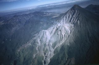 An aerial view from the SE shows the Santiaguito lava dome complex at the base of the 1.5-km-wide 1902 crater on the SW flank of Santa María. Lava flows from the Caliente dome at the eastern side of Santiaguito descend to the bottom center of the photo; lava flows from the western El Brujo vent are visible at the lower left. The broad volcano to the upper left is Siete Orejas.
 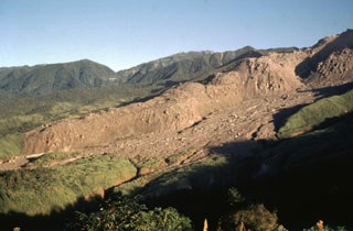 The thick unvegetated lava flow descending diagonally across the photo originated from El Brujo (upper right) at the western end of the Santiaguito lava dome complex. This north-looking 1970 view shows Santiaguito's SW-flank topography prior to a period of rapid lava extrusion from El Brujo during 1972-75. The flanks of Siete Orejas volcano form the horizon.
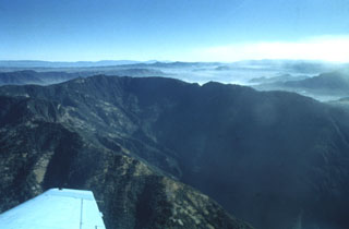 The southern side of Siete Orejas volcano is cut by a large breached caldera drained by the Ocosito river. The caldera, seen here from the SW, is 3.5 km wide and more than 10 km long, and its walls tower about 1000 m above the caldera floor. The origin of the caldera is uncertain, but may involve one or more processes including collapse following a major explosive eruption, collapse by slope failure, and excavation by headward stream erosion.
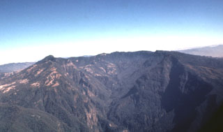 The massive breached caldera of Siete Orejas volcano is seen here from the south, the direction in which it is breached by the Ocosito river. Irregularities on the broad rim of the 3.5 x 10 km caldera give the volcano its name, which means "Seven Ears."
  Massive airfall pumice deposits blanket the countryside around Siete Orejas volcano. The coarse white rhyodacitic pumice creates the impression of snowfall over broad areas, and on the volcano itself the mantle is so thick that underlying lavas are rarely exposed. Eruption of the airfall pumice was followed by the production of massive pumiceous pyroclastic flows that filled the valley of Quetzaltenango to depths up to about 75 m.
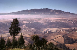 The NE flanks of the broad Siete Orejas massif rise above farmlands on the banks of the Sigüilá river. A large caldera is breached to the south, on the opposite side of the volcano. The volcano overlooks Quetzaltenango, Guatemala's second largest city, which is out of view to the left. The broad irregular summit profile gives the volcano its name, which means "Seven Ears." The latest eruption of Siete Orejas is stratigraphically constrained to have occurred between about 126,000 and 85,000 years ago.
 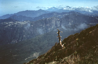 The deep valley cutting across the center of the photo is the elongated breached caldera of Siete Orejas volcano. It is seen here from the SE from near the summit of Santa María volcano. Light-colored areas on the caldera rim are voluminous rhyodacitic pumice deposits from Siete Orejas. Tacaná volcano on the México/Guatemala border is on the left-center horizon, and Tajumulco is visible to its right. These are the two highest volcanoes of Guatemala.
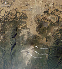 Santa María, located south of the city Quetzaltenango, is one of the country's most active volcanoes. The Santiaguito lava dome complex was constructed within a large crater formed during the 1902 eruption. The unvegetated lava flow above and to the right of Santa María was erupted from Cerro Quemado, part of the Almolonga volcanic complex, which also includes the series of lava domes to the north of Cerro Quemado. The large forested valley to the left is part of Siete Orejas volcano.
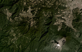 The large scarp of Siete Orejas is down the center of this November 2020 Planet Labs satellite image monthly mosaic (N is at the top; this image is approximately 21 km across). Seven peaks surround the scarp, which likely formed during flank collapse towards the south. The city of Quetzaltenango is NE and Santa María volcano is SE, with a gas plume rising from the Caliente Dome. The Volcan Chicabal is on the SW flank, containing Chicabal Lake.
There are no samples for Siete Orejas in the Smithsonian's NMNH Department of Mineral Sciences Rock and Ore collection.
| Copernicus Browser | The Copernicus Browser replaced the Sentinel Hub Playground browser in 2023, to provide access to Earth observation archives from the Copernicus Data Space Ecosystem, the main distribution platform for data from the EU Copernicus missions. |
|
WOVOdat
Single Volcano View Temporal Evolution of Unrest Side by Side Volcanoes |
WOVOdat is a database of volcanic unrest; instrumentally and visually recorded changes in seismicity, ground deformation, gas emission, and other parameters from their normal baselines. It is sponsored by the World Organization of Volcano Observatories (WOVO) and presently hosted at the Earth Observatory of Singapore.
GVMID Data on Volcano Monitoring Infrastructure The Global Volcano Monitoring Infrastructure Database GVMID, is aimed at documenting and improving capabilities of volcano monitoring from the ground and space. GVMID should provide a snapshot and baseline view of the techniques and instrumentation that are in place at various volcanoes, which can be use by volcano observatories as reference to setup new monitoring system or improving networks at a specific volcano. These data will allow identification of what monitoring gaps exist, which can be then targeted by remote sensing infrastructure and future instrument deployments. |
| IRIS seismic stations/networks | Incorporated Research Institutions for Seismology (IRIS) Data Services map showing the location of seismic stations from all available networks (permanent or temporary) within a radius of 0.18° (about 20 km at mid-latitudes) from the given location of Siete Orejas. Users can customize a variety of filters and options in the left panel. Note that if there are no stations are known the map will default to show the entire world with a "No data matched request" error notice. |
| UNAVCO GPS/GNSS stations | Geodetic Data Services map from UNAVCO showing the location of GPS/GNSS stations from all available networks (permanent or temporary) within a radius of 20 km from the given location of Siete Orejas. Users can customize the data search based on station or network names, location, and time window. Requires Adobe Flash Player. |
| Large Eruptions of Siete Orejas | Information about large Quaternary eruptions (VEI >= 4) is cataloged in the Large Magnitude Explosive Volcanic Eruptions (LaMEVE) database of the Volcano Global Risk Identification and Analysis Project (VOGRIPA). |
| EarthChem | EarthChem develops and maintains databases, software, and services that support the preservation, discovery, access and analysis of geochemical data, and facilitate their integration with the broad array of other available earth science parameters. EarthChem is operated by a joint team of disciplinary scientists, data scientists, data managers and information technology developers who are part of the NSF-funded data facility Integrated Earth Data Applications (IEDA). IEDA is a collaborative effort of EarthChem and the Marine Geoscience Data System (MGDS). |

