The Global Volcanism Program has no activity reports available for San Diego.
The Global Volcanism Program has no Weekly Reports available for San Diego.
The Global Volcanism Program has no Bulletin Reports available for San Diego.
|
|
||||||||||||||||||||||||||
The Global Volcanism Program is not aware of any Holocene eruptions from San Diego. If this volcano has had large eruptions (VEI >= 4) prior to 12,000 years ago, information might be found on the San Diego page in the LaMEVE (Large Magnitude Explosive Volcanic Eruptions) database, a part of the Volcano Global Risk Identification and Analysis Project (VOGRIPA).
This compilation of synonyms and subsidiary features may not be comprehensive. Features are organized into four major categories: Cones, Craters, Domes, and Thermal Features. Synonyms of features appear indented below the primary name. In some cases additional feature type, elevation, or location details are provided.
Synonyms |
||||
| Güija Volcanic Field | ||||
Cones |
||||
| Feature Name | Feature Type | Elevation | Latitude | Longitude |
| Clara, Laguneta | Pyroclastic cone | 480 m | 14° 18' 0.00" N | 89° 28' 0.00" W |
| Iguana, Loma | Pyroclastic cone | 521 m | 14° 17' 0.00" N | 89° 30' 0.00" W |
| Masatepeque, Cerro | Pyroclastic cone | 540 m | 14° 18' 0.00" N | 89° 29' 0.00" W |
| Pajalitos, Loma los | Pyroclastic cone | 500 m | 14° 18' 0.00" N | 89° 30' 0.00" W |
| Quemado, Cerro | Pyroclastic cone | 460 m | 14° 15' 0.00" N | 89° 28' 0.00" W |
| Tule, Cerro el | Cone | 468 m | 14° 15' 0.00" N | 89° 29' 0.00" W |
| Vega de la Cana, Cerro la | Pyroclastic cone | 465 m | 14° 17' 0.00" N | 89° 30' 0.00" W |
 Cerro Quemado scoria cone near of the outlet of Lake Güija has been extensively quarried, and only a remnant remains. The San Diego volcanic field is along the El Salvador/Guatemala border and contains numerous scoria cones and associated lava flows on both sides of Lake Güija.
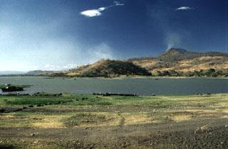 An extensive volcanic field of scoria cones and lava flows near Lake Güija is named after its largest feature, Volcán de San Diego (upper right). A large lava flow from the San Diego scoria cone dammed the drainage and was responsible for the formation of 12-km-long Lake Güija, which lies mostly in El Salvador and extends across the border into Guatemala. Cerro el Tule scoria cone in the center of the photo is near the eastern shore of the lake.
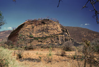
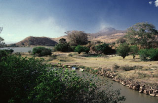 Volcán de San Diego (upper right) is seen here from the south at the outlet of Lake Güija. The lake formed after lava flows from San Diego blocked the channel of the Desagüe river. Cerro el Tule (left) lies across a narrow channel from the lower flanks of San Diego. Cerro el Tule contains a summit crater and is one of the many cones of the San Diego volcanic field.
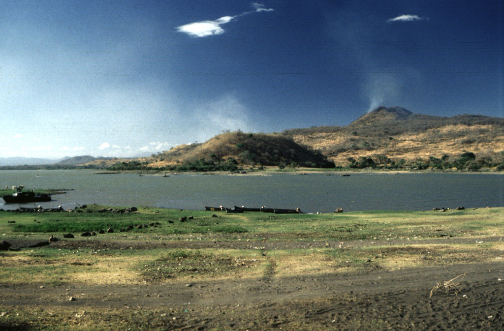
 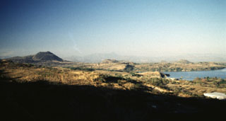 A panoramic view from the NE shows from left to right Volcán de San Diego, Cerro Masatepeque, and Loma Iguana. Laguna de Metapán is to the right. San Diego is the largest cone of a volcanic field surrounding Lake Güija on the El Salvador/Guatemala border. Lava flows from smaller vents of the San Diego volcanic field were responsible for blocking drainages and forming Laguna de Metapán, and the larger Lago de Güija was formed as a result of flows from Volcán de San Diego.
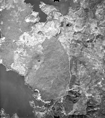 Young lava flows from Volcán de San Diego (left center) extend into Lake Güija (lower left). The prominent cinder cone on the lake shore directly south of Volcán de San Diego is Cerro el Tule. Young basaltic lava flows from other vents of the San Diego volcanic field in western El Salvador, such as Cerro la Vega de la Cana and Loma Iguana (upper left), extend into both Lake Güija and Laguna de Metapán at the top of the photo. The cinder cone north of Volcán de San Diego (surrounded by older lava flows) is Cerro Masatepeque.
There are no samples for San Diego in the Smithsonian's NMNH Department of Mineral Sciences Rock and Ore collection.
| Copernicus Browser | The Copernicus Browser replaced the Sentinel Hub Playground browser in 2023, to provide access to Earth observation archives from the Copernicus Data Space Ecosystem, the main distribution platform for data from the EU Copernicus missions. |
|
WOVOdat
Single Volcano View Temporal Evolution of Unrest Side by Side Volcanoes |
WOVOdat is a database of volcanic unrest; instrumentally and visually recorded changes in seismicity, ground deformation, gas emission, and other parameters from their normal baselines. It is sponsored by the World Organization of Volcano Observatories (WOVO) and presently hosted at the Earth Observatory of Singapore.
GVMID Data on Volcano Monitoring Infrastructure The Global Volcano Monitoring Infrastructure Database GVMID, is aimed at documenting and improving capabilities of volcano monitoring from the ground and space. GVMID should provide a snapshot and baseline view of the techniques and instrumentation that are in place at various volcanoes, which can be use by volcano observatories as reference to setup new monitoring system or improving networks at a specific volcano. These data will allow identification of what monitoring gaps exist, which can be then targeted by remote sensing infrastructure and future instrument deployments. |
| IRIS seismic stations/networks | Incorporated Research Institutions for Seismology (IRIS) Data Services map showing the location of seismic stations from all available networks (permanent or temporary) within a radius of 0.18° (about 20 km at mid-latitudes) from the given location of San Diego. Users can customize a variety of filters and options in the left panel. Note that if there are no stations are known the map will default to show the entire world with a "No data matched request" error notice. |
| UNAVCO GPS/GNSS stations | Geodetic Data Services map from UNAVCO showing the location of GPS/GNSS stations from all available networks (permanent or temporary) within a radius of 20 km from the given location of San Diego. Users can customize the data search based on station or network names, location, and time window. Requires Adobe Flash Player. |
| Large Eruptions of San Diego | Information about large Quaternary eruptions (VEI >= 4) is cataloged in the Large Magnitude Explosive Volcanic Eruptions (LaMEVE) database of the Volcano Global Risk Identification and Analysis Project (VOGRIPA). |
| EarthChem | EarthChem develops and maintains databases, software, and services that support the preservation, discovery, access and analysis of geochemical data, and facilitate their integration with the broad array of other available earth science parameters. EarthChem is operated by a joint team of disciplinary scientists, data scientists, data managers and information technology developers who are part of the NSF-funded data facility Integrated Earth Data Applications (IEDA). IEDA is a collaborative effort of EarthChem and the Marine Geoscience Data System (MGDS). |

