
Tectonic earthquake swarm declines; no volcanic tremor or other activity
The following explanation of the recent seismicity on Dominica (BGVN 23:11) was provided by John Shepherd of the Seismic Research Unit.
"There has indeed been a series of earthquakes in Dominica, West Indies, over the past few months. The sequence reached an apparent climax on 22-23 October 1998 when a total of about 370 earthquakes occurred, of which over 100 were felt. Since then earthquake numbers have declined irregularly with smaller maxima in numbers on 6 and 30 December 1998. At the present time (5 February 1999) the rate of activity has declined to a few earthquakes per week, which is about the background level which we have observed for the past 30 years.
"The earthquakes are part of a pattern which has continued for at least 250 years. The present earthquakes are NOT directly associated with Morne Patates or any other volcano in Dominica and there have been absolutely no other signs of volcanic activity. Dominica is in the center of the tectonically-active Lesser Antilles, and non-volcanic earthquakes are frequent. Dominicans refer to felt earthquakes as 'tremors.' This has no scientific significance; the earthquakes are conventional local earthquakes and no volcanic tremor has been recorded.
"There is undoubtedly a continuous volcanic hazard and many Dominicans have become concerned because this particular set of earthquakes follows closely on the recent events in the nearby island of Montserrat. For this reason the government of the Commonwealth of Dominica has conducted an intensive program of public awareness in which we have participated. We are also assisting in the preparation of an updated volcanic hazards map for Dominica."
Information Contacts: John B. Shepherd, Head of Seismic Research, The University of the West Indies, St. Augustine, Trinidad.
The Global Volcanism Program has no Weekly Reports available for Morne Plat Pays.
Reports are organized chronologically and indexed below by Month/Year (Publication Volume:Number), and include a one-line summary. Click on the index link or scroll down to read the reports.
Earthquake swarm but thermal activity unchanged
Four swarms of felt earthquakes centered near Morne Patates . . . have occurred since March (table 1). Activity typically consisted of 10-30 recorded A-type volcanic shocks in a roughly two-hour period, about half of them felt by residents of flank villages. The most recent swarm occurred on 29 October (after 10 days of quiet) when 26 earthquakes were felt between 0000 and 0200. As of 12 November, no new swarms had been recorded.
Table 1. 1986 earthquake swarms at Morne Patates, recorded by three telemetered seismometers on Dominica and 15 others within 100 km of the island.
| Date | Number of recorded events |
| 09-15 Mar 1986 | 15 |
| 15-16 Sep 1986 | 15 |
| 19 Oct 1986 | 9 |
| 29 Oct 1986 | 26 |
Three telemetered seismometers on Dominica and 15 others within 100 km recorded the events. Precise depth and magnitude determinations were difficult, but the events were shallow, perhaps at ~3 km depth, and the largest had duration magnitudes of 3-3.5. Instruments were able to detect events of about M 2 or larger. Geologists visited the area in early November and installed four additional seismic instruments in the epicentral area; data will be telemetered to Trinidad. Fumaroles in the crater and on the N flank appeared unchanged and no other surface changes were evident.
Information Contacts: J. Shepherd, UWI; C. Antenor-Habezac, Observatoire Volcanologique de la Soufriere, Guadeloupe.
Burning sulfur deposits cause false eruption report
A fire of unknown origin burned 10 m2 of accumulated sulfur deposits in the Soufriere Sulphur Springs area (~700 m SSW of the summit), causing false eruption reports. The alleged eruption was reported by residents to have started on 24 April with the formation of small lava flows. Authorities in the capital of Roseau passed the information to the Seismic Research Unit in Trinidad. A team was sent to investigate the report on 27 April. No local seismic activity was detected at the permanent seismographic station, located 1.5 km away, or by the portable seismometer installed at the site during the visit.
Information Contacts: W. Ambeh, L. Lynch, and R. Robertson, UWI.
Strong earthquake swarms, tremor
According to reports from local news sources and USAID's Office of Foreign Disaster Assistance (OFDA), earthquake swarms began on the island of Dominica on 11 September and continued intermittently into October. The Seismic Research Unit (SRU) of the University of the West Indies started monitoring the activity on 28 September and determined that [seismicity] was occurring in the S part of the island beneath Morne Patates volcano. By 23 October the [seismicity] had subsided to about two [earthquake] events per hour, with 10% large enough to be felt.
An earthquake recorded by SRU at 1018 on 24 September had its epicenter at 15.28°N, 61.37°W. It occurred at a depth of 15 km with a body-wave magnitude of 2.9 and a Richter magnitude of 1 to 3. A spasmodic (new events were starting before the previous were finished) sequence of activity started about 1500 on 22 October. These events were less than 6 km deep and had a maximum magnitude of 3.5 Richter and an intensity of MM V. On 23 October, an SRU aerial reconnaissance revealed no surface manifestations of the events (i.e., scarps, vents).
The strong [felt earthquakes] on 22-23 October were described as the longest and most intense in recent times. These [earthquakes] caused landslides and road closures, including the main road from the capital, Roseau, to the communities on the S end of the island. The SRU stated on 22 October that 27 was the maximum number of [events] recorded within a 24-hour period since 28 September, noting that the daily numbers were not as high as during the 1974 sequence.
Morne Patates, at the southern tip of Dominica, is an arcuate structure open to Soufriere Bay on the west. It was constructed within an irregular depression on the SW flank of a larger stratovolcano, Morne Plat Pays, whose summit is only 3 km NE. The latest eruptions occurred at about 450 ± 90 years BP (Roobol and others, 1983) from the Morne Patates lava dome just prior to European settlement. At least ten swarms of small-magnitude earthquakes have occurred since 1765. The most recent swarm, between March and October 1986, consisted of 10-30 recorded A-type volcanic shocks in about two hours. No eruptive activity followed any of these swarms and no systematic shallowing was documented to indicate upward migration of magma.
General References. Roobol, M.J., Wright, J.V., and Smith, A.L., 1983, Calderas or gravity-slide structures in the Lesser Antilles Island Arc?: JVGR, v. 19, p. 121-134.
Information Contacts: Tina Neal, OFDA/USAID, 1300 Pennsylvania Ave. NW, Washington, DC 20523-8602 (URL: http://www.info.usaid.gov/ofda/ofda.htm); CaKaFete News, 25-12 Street, Canefield, Dominica (URL: http://www.cakafete.com/).
Tectonic earthquake swarm declines; no volcanic tremor or other activity
The following explanation of the recent seismicity on Dominica (BGVN 23:11) was provided by John Shepherd of the Seismic Research Unit.
"There has indeed been a series of earthquakes in Dominica, West Indies, over the past few months. The sequence reached an apparent climax on 22-23 October 1998 when a total of about 370 earthquakes occurred, of which over 100 were felt. Since then earthquake numbers have declined irregularly with smaller maxima in numbers on 6 and 30 December 1998. At the present time (5 February 1999) the rate of activity has declined to a few earthquakes per week, which is about the background level which we have observed for the past 30 years.
"The earthquakes are part of a pattern which has continued for at least 250 years. The present earthquakes are NOT directly associated with Morne Patates or any other volcano in Dominica and there have been absolutely no other signs of volcanic activity. Dominica is in the center of the tectonically-active Lesser Antilles, and non-volcanic earthquakes are frequent. Dominicans refer to felt earthquakes as 'tremors.' This has no scientific significance; the earthquakes are conventional local earthquakes and no volcanic tremor has been recorded.
"There is undoubtedly a continuous volcanic hazard and many Dominicans have become concerned because this particular set of earthquakes follows closely on the recent events in the nearby island of Montserrat. For this reason the government of the Commonwealth of Dominica has conducted an intensive program of public awareness in which we have participated. We are also assisting in the preparation of an updated volcanic hazards map for Dominica."
Information Contacts: John B. Shepherd, Head of Seismic Research, The University of the West Indies, St. Augustine, Trinidad.
|
|
||||||||||||||||||||||||||
There is data available for 4 confirmed eruptive periods.
1270 ± 50 years Confirmed Eruption (Explosive / Effusive)
| Episode 1 | Eruption (Explosive / Effusive) | Morne Patates | |||||||||||||||||||||||
|---|---|---|---|---|---|---|---|---|---|---|---|---|---|---|---|---|---|---|---|---|---|---|---|---|
| 1270 ± 50 years - Unknown | Evidence from Isotopic: 14C (uncalibrated) | |||||||||||||||||||||||
|
List of 3 Events for Episode 1 at Morne Patates
|
||||||||||||||||||||||||
0390 ± 40 years Confirmed Eruption (Explosive / Effusive)
| Episode 1 | Eruption (Explosive / Effusive) | Morne Patates | ||||||||||||||||||||||||||||
|---|---|---|---|---|---|---|---|---|---|---|---|---|---|---|---|---|---|---|---|---|---|---|---|---|---|---|---|---|---|
| 0390 ± 40 years - Unknown | Evidence from Isotopic: 14C (uncalibrated) | ||||||||||||||||||||||||||||
|
List of 4 Events for Episode 1 at Morne Patates
|
|||||||||||||||||||||||||||||
0430 BCE (?) Confirmed Eruption (Explosive / Effusive)
| Episode 1 | Eruption (Explosive / Effusive) | Morne Patates ? | ||||||||||||||||||
|---|---|---|---|---|---|---|---|---|---|---|---|---|---|---|---|---|---|---|---|
| 0430 BCE (?) - Unknown | Evidence from Isotopic: 14C (uncalibrated) | ||||||||||||||||||
|
List of 2 Events for Episode 1 at Morne Patates ?
|
|||||||||||||||||||
4740 BCE (?) Confirmed Eruption (Explosive / Effusive)
| Episode 1 | Eruption (Explosive / Effusive) | Morne Plat Pays | |||||||||||||||||||||||
|---|---|---|---|---|---|---|---|---|---|---|---|---|---|---|---|---|---|---|---|---|---|---|---|---|
| 4740 BCE (?) - Unknown | Evidence from Isotopic: 14C (uncalibrated) | |||||||||||||||||||||||
|
List of 3 Events for Episode 1 at Morne Plat Pays
|
||||||||||||||||||||||||
This compilation of synonyms and subsidiary features may not be comprehensive. Features are organized into four major categories: Cones, Craters, Domes, and Thermal Features. Synonyms of features appear indented below the primary name. In some cases additional feature type, elevation, or location details are provided.
Cones |
||||
| Feature Name | Feature Type | Elevation | Latitude | Longitude |
| Plat Pays, Morne | Stratovolcano | 960 m | 15° 15' 0.00" N | 61° 21' 0.00" W |
| Rouge, Morne | Cone | 460 m | 15° 13' 0.00" N | 61° 21' 0.00" W |
Domes |
||||
| Feature Name | Feature Type | Elevation | Latitude | Longitude |
| Acouma, Morne | Dome | 400 m | 15° 14' 0.00" N | 61° 22' 0.00" W |
| Bois d'Inde | Dome | 379 m | 15° 13' 30.00" N | 61° 20' 0.00" W |
| Cabrits, Morne | Dome | 350 m | 15° 14' 30.00" N | 61° 22' 30.00" W |
| Canot, Morne | Dome | 730 m | 15° 16' 0.00" N | 61° 22' 0.00" W |
| Crabier, Morne | Dome | 520 m | 15° 13' 0.00" N | 61° 22' 0.00" W |
| Eloi, Morne | Dome | 580 m | 15° 15' 0.00" N | 61° 22' 0.00" W |
| Falaise, La | Dome | 490 m | 15° 16' 0.00" N | 61° 23' 0.00" W |
| Fous, Morne | Dome | 370 m | 15° 13' 0.00" N | 61° 21' 0.00" W |
| Hagley | Dome | 460 m | 15° 14' 0.00" N | 61° 20' 0.00" W |
| Mountain Top | Dome | -30 m | 15° 12' 0.00" N | 61° 23' 0.00" W |
| Patates, Morne
Potato Moutain |
Dome | 410 m | 15° 13' 0.00" N | 61° 22' 0.00" W |
| Pichelin | Dome | 350 m | 15° 15' 0.00" N | 61° 20' 0.00" W |
| Powell | Dome | 370 m | 15° 14' 0.00" N | 61° 20' 0.00" W |
| Rouge, Morne | Dome | 453 m | 15° 13' 0.00" N | 61° 21' 0.00" W |
| Scotts Head | Dome | 60 m | 15° 13' 0.00" N | 61° 23' 0.00" W |
| Socrière, La | Dome | 270 m | 15° 14' 0.00" N | 61° 23' 0.00" W |
| Vert, Morne | Dome | 640 m | 15° 13' 0.00" N | 61° 21' 0.00" W |
| Vue, Morne la
Vigie, Morne la |
Dome | 370 m | 15° 15' 0.00" N | 61° 23' 0.00" W |
Thermal |
||||
| Feature Name | Feature Type | Elevation | Latitude | Longitude |
| Champagne | Thermal | 0 m | 15° 14' 0.00" N | 61° 22' 0.00" W |
| Galion | Thermal | 300 m | 15° 13' 0.00" N | 61° 21' 0.00" W |
| Sulfur Springs
Terre Elm |
Hot Spring | 200 m | 15° 15' 0.00" N | 61° 21' 0.00" W |
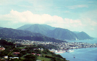 The cloud-capped summit of Morne Plat Pays stratovolcano lies on the horizon near the southern tip of the island of Dominica beyond the sprawling capital city of Roseau. Three post-caldera lava domes (left-center to right) were formed north of a large arcuate depression open to the west that formed about 39,000 years ago. The latest dated eruption at the Morne Plat Pays volcanic complex occurred from the Morne Patates lava dome about 1270 CE, although younger deposits have not yet been dated.
 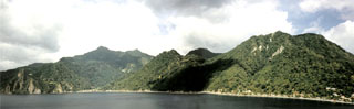 The 4-km-wide caldera of the Morne Plat Pays volcanic complex is widely breached to the sea of the west in this view from Scotts Head lava dome. It formed about 39,000 years ago following a major plinian explosive eruption and flank collapse that truncated Morne Plat Pays stratovolcano, the peak on the left-center horizon. The northern caldera margin lies immediately north of the post-caldera Socrière lava dome at the far left and near Soufrière village at the far right. Post-caldera lava domes form the center-to-right horizon.
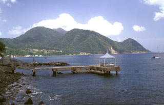 The Plat Pays volcanic complex rises to the south beyond the shoreline of the city of Roseau in the foreground. Three lava domes that formed after the roughly 39,000-year-old caldera collapse at Plat Pays lie on the horizon. On the left is the rounded Morne Canot dome, in the center is La Falaise dome, and the peak at the far right is Morne la Vue, which rises above the village of Pointe Michel. The summit of the Morne Plat Pays stratovolcano lies in the left-center background between Morne Canot and La Falaise domes.
 Volcano eco-tourism is a major component of the economy of the island of Dominica. The cruise ship Queen Elizabeth II anchors in Roseau harbor with Morne Plat Pays volcano in the background. The Valley of Desolation thermal area is a popular destination for island visitors.
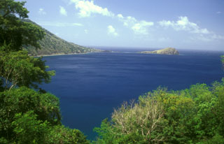 Scotts Head lava dome forms a dramatic promontory marking the southern margin of Soufrière Bay and is connected by a narrow spit only a few meters high to Scotts Head village (left-center). The weathered hill (also known as Pointe Cachacrou) consists of subvertical lava sheets and is a remnant of lava dome extruded along a fracture inboard of the southern margin of the Soufrière Bay depression. The slopes of Crabier lava dome rise at the left.
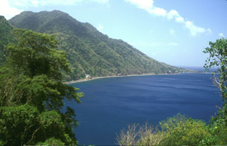 The Crabier lava dome rises about 500 m above the western shores of Soufrière Bay, with Scotts Head village at the far right. The dome is one of the youngest post-caldera features of the Morne Plat Pays volcanic complex. The Galion thermal area lies in the saddle (upper left) between Crabier and the Morne Patates lava dome.
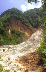 The upper Sulphur Springs geothermal area cuts the SW flank of Morne Plat Pays stratovolcano and lies just inside the large scarp formed by collapse of the edifice. The thermal area consists of steaming, hydrothermally altered ground with yellowish area marking many sulfur-encrusted fumaroles with temperatures of from 90-100 degrees Centigrade measured during the past century. Minor hot springs are also present.
 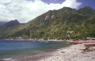 The Morne Patates (far left) and Crabier (right) lava domes, the youngest features of the Morne Plat Pays volcanic complex, rise above Scotts Head village on the southern tip of Dominica. The youngest dated eruption from Morne Patates took place about 685 years Before Present (BP) and produced block and ash flow deposits. Similar deposits were dated at about 1560 yrs BP, and an airfall deposit dated at about 2380 yrs BP also originated from this group of young lava domes.
 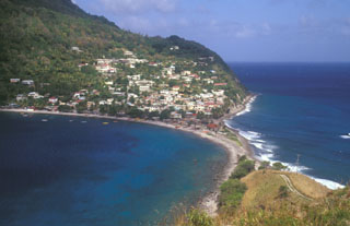 A narrow sand-and-gravel bar connects the picturesque fishing village of Scotts Head, the southernmost on Dominica, to the Scotts Head lava dome. The village, also known as Cachacrou, overlies volcaniclastic deposits on the SW flank of Crabier lava dome, a post-caldera dome near the southern rim of the Morne Plat Pays caldera.
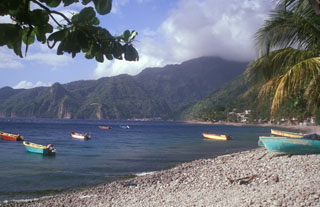 The summit of the steep-sided Sorcière lava dome rises from the coast at the left to just above the horizon. Morne Acouma lava dome (left-center) lies to the right of Sorcière in this view from Soufrière harbor (south of the domes) and was the source of a lava flow that extends to the northern edge of the town. Coastal cliffs below the domes consist of block and ash flow deposits associated with growth of the domes. The dacitic Morne Acouma dome is older than about 28,500 years.
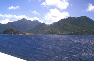 Scotts Head lava dome (left foreground) forms a narrow peninsula extending from the village of Scotts Head (right) on the southern tip of Dominica. A submarine lava dome, named Mountain Top, is thought to be less than 9000 years old and rises to within 30 m of the sea surface about a kilometer south of Scotts Head dome. The peak on the left horizon is Morne Play Pays stratovolcano; the post-caldera lava domes of Morne Patates, Crabier, and Morne Rouge form the center-to-right horizon.
 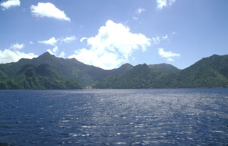 Morne Plat Pays (left), Morne Patates (right-center) and Crabier (right) at the SW tip of Dominica are seen from the SW. The Morne Plat Pays volcanic complex contains the Morne Plat Pays stratovolcano and a complex of central lava domes. The complex is cut by a large depression, partly filled by the lava domes, that was formed by collapse of the volcano during the late Pleistocene. The collapse scarp is 400-900 m high, and submarine debris-avalanche blocks from the collapse are visible in bathymetry.
 The youngest cluster of lava domes of the Morne Plat Pays volcanic complex, Morne Rouge, Crabier, and Morne Patates (left to right) is seen here from the north at the upper Sulfur Springs thermal area. The cliff in the shadow at the left is the west-facing wall of the arcuate Morne Plat Pays caldera, which formed about 39,000 years ago in association with the eruption of the Grand Bay Ignimbrite and a lateral flank collapse to the west.
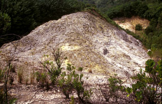 The Sulfur Springs thermal area was the site of combustion and melting of sulfur deposits in 1994 that produced a sulfur flow over an area of about 1 km2, prompting reports of a volcanic eruption. Measured fumarole temperatures at Sulfur Springs have ranged between about 90 and 100 degrees Centigrade over the past century.
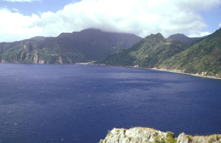 The promontory at Scotts Head provides a vantage point overlooking the partially submerged Plat Pays caldera, widely breached to the west at Soufrière Bay. The caldera, which partially truncated Morne Plat Pays stratovolcano (in the clouds on the center horizon) formed about 39,000 years ago. Its margins extend from north of Sorcière lava dome (far left) to near Scotts Head. Morne Patates, the dome along the coast at the right-center, is the youngest post-caldera lava dome and was active until at least about 700 years ago.
There are no samples for Morne Plat Pays in the Smithsonian's NMNH Department of Mineral Sciences Rock and Ore collection.
| Copernicus Browser | The Copernicus Browser replaced the Sentinel Hub Playground browser in 2023, to provide access to Earth observation archives from the Copernicus Data Space Ecosystem, the main distribution platform for data from the EU Copernicus missions. |
| MIROVA | Middle InfraRed Observation of Volcanic Activity (MIROVA) is a near real time volcanic hot-spot detection system based on the analysis of MODIS (Moderate Resolution Imaging Spectroradiometer) data. In particular, MIROVA uses the Middle InfraRed Radiation (MIR), measured over target volcanoes, in order to detect, locate and measure the heat radiation sourced from volcanic activity. |
| MODVOLC Thermal Alerts | Using infrared satellite Moderate Resolution Imaging Spectroradiometer (MODIS) data, scientists at the Hawai'i Institute of Geophysics and Planetology, University of Hawai'i, developed an automated system called MODVOLC to map thermal hot-spots in near real time. For each MODIS image, the algorithm automatically scans each 1 km pixel within it to check for high-temperature hot-spots. When one is found the date, time, location, and intensity are recorded. MODIS looks at every square km of the Earth every 48 hours, once during the day and once during the night, and the presence of two MODIS sensors in space allows at least four hot-spot observations every two days. Each day updated global maps are compiled to display the locations of all hot spots detected in the previous 24 hours. There is a drop-down list with volcano names which allow users to 'zoom-in' and examine the distribution of hot-spots at a variety of spatial scales. |
|
WOVOdat
Single Volcano View Temporal Evolution of Unrest Side by Side Volcanoes |
WOVOdat is a database of volcanic unrest; instrumentally and visually recorded changes in seismicity, ground deformation, gas emission, and other parameters from their normal baselines. It is sponsored by the World Organization of Volcano Observatories (WOVO) and presently hosted at the Earth Observatory of Singapore.
GVMID Data on Volcano Monitoring Infrastructure The Global Volcano Monitoring Infrastructure Database GVMID, is aimed at documenting and improving capabilities of volcano monitoring from the ground and space. GVMID should provide a snapshot and baseline view of the techniques and instrumentation that are in place at various volcanoes, which can be use by volcano observatories as reference to setup new monitoring system or improving networks at a specific volcano. These data will allow identification of what monitoring gaps exist, which can be then targeted by remote sensing infrastructure and future instrument deployments. |
| Volcanic Hazard Maps | The IAVCEI Commission on Volcanic Hazards and Risk has a Volcanic Hazard Maps database designed to serve as a resource for hazard mappers (or other interested parties) to explore how common issues in hazard map development have been addressed at different volcanoes, in different countries, for different hazards, and for different intended audiences. In addition to the comprehensive, searchable Volcanic Hazard Maps Database, this website contains information about diversity of volcanic hazard maps, illustrated using examples from the database. This site is for educational purposes related to volcanic hazard maps. Hazard maps found on this website should not be used for emergency purposes. For the most recent, official hazard map for a particular volcano, please seek out the proper institutional authorities on the matter. |
| IRIS seismic stations/networks | Incorporated Research Institutions for Seismology (IRIS) Data Services map showing the location of seismic stations from all available networks (permanent or temporary) within a radius of 0.18° (about 20 km at mid-latitudes) from the given location of Morne Plat Pays. Users can customize a variety of filters and options in the left panel. Note that if there are no stations are known the map will default to show the entire world with a "No data matched request" error notice. |
| UNAVCO GPS/GNSS stations | Geodetic Data Services map from UNAVCO showing the location of GPS/GNSS stations from all available networks (permanent or temporary) within a radius of 20 km from the given location of Morne Plat Pays. Users can customize the data search based on station or network names, location, and time window. Requires Adobe Flash Player. |
| DECADE Data | The DECADE portal, still in the developmental stage, serves as an example of the proposed interoperability between The Smithsonian Institution's Global Volcanism Program, the Mapping Gas Emissions (MaGa) Database, and the EarthChem Geochemical Portal. The Deep Earth Carbon Degassing (DECADE) initiative seeks to use new and established technologies to determine accurate global fluxes of volcanic CO2 to the atmosphere, but installing CO2 monitoring networks on 20 of the world's 150 most actively degassing volcanoes. The group uses related laboratory-based studies (direct gas sampling and analysis, melt inclusions) to provide new data for direct degassing of deep earth carbon to the atmosphere. |
| Large Eruptions of Morne Plat Pays | Information about large Quaternary eruptions (VEI >= 4) is cataloged in the Large Magnitude Explosive Volcanic Eruptions (LaMEVE) database of the Volcano Global Risk Identification and Analysis Project (VOGRIPA). |
| EarthChem | EarthChem develops and maintains databases, software, and services that support the preservation, discovery, access and analysis of geochemical data, and facilitate their integration with the broad array of other available earth science parameters. EarthChem is operated by a joint team of disciplinary scientists, data scientists, data managers and information technology developers who are part of the NSF-funded data facility Integrated Earth Data Applications (IEDA). IEDA is a collaborative effort of EarthChem and the Marine Geoscience Data System (MGDS). |

