

On 9 November Icelandic Meteorological Office (IMO) lowered the Aviation Color Code for Askja to Green (the lowest level on a four-color scale) noting that although deformation data indicted continuing magma accumulation at depth, with a total uplift of 40 cm since August 2021, it was not accompanied by elevated seismicity.
2022: July
| November
2021: September
2014: September
On 9 November Icelandic Meteorological Office (IMO) lowered the Aviation Color Code for Askja to Green (the lowest level on a four-color scale) noting that although deformation data indicted continuing magma accumulation at depth, with a total uplift of 40 cm since August 2021, it was not accompanied by elevated seismicity.
Source: Icelandic Meteorological Office (IMO)
On 27 July IMO stated that uplift at Askja began in August 2021 and since then had totaled 35 cm, centered in the W part of Askja lake. The uplift was rapid, compared to similar volcanoes around the world, and likely caused by a magmatic intrusion at an estimated depth of 2 km. Seismicity remained low.
Source: Icelandic Meteorological Office (IMO)
On 9 September IMO raised the Aviation Color Code for Askja to Yellow, noting that inflation that began in early August was ongoing and notably rapid. The uplift was centered at the W edge of Oskjuvatn caldera, which rose a total of 7 cm. The data suggested that magma was accumulating at 2-3.5 km depth.
Source: Icelandic Meteorological Office (IMO)
On 3 September IMO reported that inflation at Askja had begun in early August based on ground deformation data derived from satellite images and continuous GPS data. The uplift was centered at the W edge of Oskjuvatn caldera and vertically deformed at a rate of about 5 cm per month. Data indicated that the source of the inflation was at a depth of about 3 km and caused a volume change of about 0.01 cubic kilometers per month; the source was unknown, though most likely was caused by an influx of magma. The Aviation Color Code remained at Green.
Source: Icelandic Meteorological Office (IMO)
IMO had maintained the Aviation Colour Code for Askja at Yellow since 28 August due to elevated seismicity and localized deformation. On 11 September the Colour Code was reduced to Green when seismicity had diminished significantly.
Source: Icelandic Meteorological Office (IMO)
The Global Volcanism Program has no Bulletin Reports available for Askja.
|
|
||||||||||||||||||||||||||||
There is data available for 14 confirmed Holocene eruptive periods.
1961 Oct 26 - 1961 Dec 5 ± 4 days Confirmed Eruption (Explosive / Effusive) VEI: 2
| Episode 1 | Eruption (Explosive / Effusive) | North of Öskjuvatn lake (Vikraborgir) | |||||||||||||||||||||||||||||||||||||||||||||||||
|---|---|---|---|---|---|---|---|---|---|---|---|---|---|---|---|---|---|---|---|---|---|---|---|---|---|---|---|---|---|---|---|---|---|---|---|---|---|---|---|---|---|---|---|---|---|---|---|---|---|---|
| 1961 Oct 26 - 1961 Dec 5 ± 4 days | Evidence from Observations: Reported | |||||||||||||||||||||||||||||||||||||||||||||||||
|
List of 8 Events for Episode 1 at North of Öskjuvatn lake (Vikraborgir)
|
||||||||||||||||||||||||||||||||||||||||||||||||||
1938 Dec 19 (?) Confirmed Eruption (Explosive / Effusive) VEI: 2
| Episode 1 | Eruption (Explosive / Effusive) | South shore of Öskjuvatn lake | |||||||||||||||||||||||||||||
|---|---|---|---|---|---|---|---|---|---|---|---|---|---|---|---|---|---|---|---|---|---|---|---|---|---|---|---|---|---|---|
| 1938 Dec 19 (?) - Unknown | Evidence from Observations: Reported | |||||||||||||||||||||||||||||
|
List of 4 Events for Episode 1 at South shore of Öskjuvatn lake
|
||||||||||||||||||||||||||||||
1926 Jul 15 ± 45 days Confirmed Eruption (Explosive / Effusive) VEI: 2 (?)
| Episode 1 | Eruption (Explosive / Effusive) | South end of Öskjuvatn lake | ||||||||||||||||||||||||||||||||||
|---|---|---|---|---|---|---|---|---|---|---|---|---|---|---|---|---|---|---|---|---|---|---|---|---|---|---|---|---|---|---|---|---|---|---|---|
| 1926 Jul 15 ± 45 days - Unknown | Evidence from Observations: Reported | ||||||||||||||||||||||||||||||||||
|
List of 5 Events for Episode 1 at South end of Öskjuvatn lake
|
|||||||||||||||||||||||||||||||||||
1924 (?) Confirmed Eruption (Explosive / Effusive) VEI: 0 (?)
| Episode 1 | Eruption (Explosive / Effusive) | South flank of Dyngjufjöll massif | |||||||||||||||||||
|---|---|---|---|---|---|---|---|---|---|---|---|---|---|---|---|---|---|---|---|---|
| 1924 (?) - Unknown | Evidence from Observations: Reported | |||||||||||||||||||
|
List of 2 Events for Episode 1 at South flank of Dyngjufjöll massif
|
||||||||||||||||||||
1923 Jan 15 ± 45 days Confirmed Eruption (Explosive / Effusive) VEI: 0
| Episode 1 | Eruption (Explosive / Effusive) | SE corner of Öskjuvatn Caldera | |||||||||||||||||||
|---|---|---|---|---|---|---|---|---|---|---|---|---|---|---|---|---|---|---|---|---|
| 1923 Jan 15 ± 45 days - Unknown | Evidence from Observations: Reported | |||||||||||||||||||
|
List of 2 Events for Episode 1 at SE corner of Öskjuvatn Caldera
|
||||||||||||||||||||
1922 Nov Confirmed Eruption (Explosive / Effusive) VEI: 0
| Episode 1 | Eruption (Explosive / Effusive) | 1 km SW of Öskjuvatn Caldera | |||||||||||||||||||
|---|---|---|---|---|---|---|---|---|---|---|---|---|---|---|---|---|---|---|---|---|
| 1922 Nov - Unknown | Evidence from Observations: Reported | |||||||||||||||||||
|
List of 2 Events for Episode 1 at 1 km SW of Öskjuvatn Caldera
|
||||||||||||||||||||
1921 Mar Confirmed Eruption (Explosive / Effusive) VEI: 0
| Episode 1 | Eruption (Explosive / Effusive) | NE caldera wall, 0.6 km SE of Viti | |||||||||||||||||||
|---|---|---|---|---|---|---|---|---|---|---|---|---|---|---|---|---|---|---|---|---|
| 1921 Mar - Unknown | Evidence from Observations: Reported | |||||||||||||||||||
|
List of 2 Events for Episode 1 at NE caldera wall, 0.6 km SE of Viti
|
||||||||||||||||||||
1919 Confirmed Eruption (Explosive / Effusive) VEI: 2
| Episode 1 | Eruption (Explosive / Effusive) | Dyngjufjöll | ||||||||||||||||||||||||
|---|---|---|---|---|---|---|---|---|---|---|---|---|---|---|---|---|---|---|---|---|---|---|---|---|---|
| 1919 - Unknown | Evidence from Observations: Reported | ||||||||||||||||||||||||
|
List of 3 Events for Episode 1 at Dyngjufjöll
|
|||||||||||||||||||||||||
1875 Jan 1 - 1875 Oct 17 Confirmed Eruption (Explosive / Effusive) VEI: 5
| Episode 1 | Eruption (Explosive / Effusive) | Öskjuvatn Caldera, Viti, Sveinagja | ||||||||||||||||||||||||||||||||||||||||||||||||||||||||||||||||||||||||||
|---|---|---|---|---|---|---|---|---|---|---|---|---|---|---|---|---|---|---|---|---|---|---|---|---|---|---|---|---|---|---|---|---|---|---|---|---|---|---|---|---|---|---|---|---|---|---|---|---|---|---|---|---|---|---|---|---|---|---|---|---|---|---|---|---|---|---|---|---|---|---|---|---|---|---|---|
| 1875 Jan 1 - 1875 Oct 17 | Evidence from Observations: Reported | ||||||||||||||||||||||||||||||||||||||||||||||||||||||||||||||||||||||||||
|
List of 13 Events for Episode 1 at Öskjuvatn Caldera, Viti, Sveinagja
|
|||||||||||||||||||||||||||||||||||||||||||||||||||||||||||||||||||||||||||
1797 (?) Confirmed Eruption (Explosive / Effusive) VEI: 0
| Episode 1 | Eruption (Explosive / Effusive) | Holuhraun | |||||||||||||||||||
|---|---|---|---|---|---|---|---|---|---|---|---|---|---|---|---|---|---|---|---|---|
| 1797 (?) - Unknown | Evidence from Observations: Reported | |||||||||||||||||||
|
List of 2 Events for Episode 1 at Holuhraun
|
||||||||||||||||||||
1300 (?) Confirmed Eruption (Explosive / Effusive) VEI: 1
| Episode 1 | Eruption (Explosive / Effusive) | South of Dyngjufjöll Ytri | ||||||||||||||||||||||||
|---|---|---|---|---|---|---|---|---|---|---|---|---|---|---|---|---|---|---|---|---|---|---|---|---|---|
| 1300 (?) - Unknown | Evidence from Correlation: Tephrochronology | ||||||||||||||||||||||||
|
List of 3 Events for Episode 1 at South of Dyngjufjöll Ytri
|
|||||||||||||||||||||||||
1250 BCE ± 300 years Confirmed Eruption (Explosive / Effusive) VEI: 0
| Episode 1 | Eruption (Explosive / Effusive) | Litladynga and Askja | |||||||||||||||||||||||||||||
|---|---|---|---|---|---|---|---|---|---|---|---|---|---|---|---|---|---|---|---|---|---|---|---|---|---|---|---|---|---|---|
| 1250 BCE ± 300 years - Unknown | Evidence from Correlation: Tephrochronology | |||||||||||||||||||||||||||||
|
List of 4 Events for Episode 1 at Litladynga and Askja
|
||||||||||||||||||||||||||||||
2050 BCE ± 500 years Confirmed Eruption (Explosive / Effusive) VEI: 0
| Episode 1 | Eruption (Explosive / Effusive) | Flatadyngja, other areas NE of Dyngjufjöll | |||||||||||||||||||||||||||||
|---|---|---|---|---|---|---|---|---|---|---|---|---|---|---|---|---|---|---|---|---|---|---|---|---|---|---|---|---|---|---|
| 2050 BCE ± 500 years - Unknown | Evidence from Correlation: Tephrochronology | |||||||||||||||||||||||||||||
|
List of 4 Events for Episode 1 at Flatadyngja, other areas NE of Dyngjufjöll
|
||||||||||||||||||||||||||||||
8910 BCE ± 200 years Confirmed Eruption (Explosive / Effusive) VEI: 5
| Episode 1 | Eruption (Explosive / Effusive) | SE part of Askja caldera | |||||||||||||||||||||||||||||||||||||||
|---|---|---|---|---|---|---|---|---|---|---|---|---|---|---|---|---|---|---|---|---|---|---|---|---|---|---|---|---|---|---|---|---|---|---|---|---|---|---|---|---|
| 8910 BCE ± 200 years - Unknown | Evidence from Isotopic: 14C (calibrated) | |||||||||||||||||||||||||||||||||||||||
|
List of 6 Events for Episode 1 at SE part of Askja caldera
|
||||||||||||||||||||||||||||||||||||||||
This compilation of synonyms and subsidiary features may not be comprehensive. Features are organized into four major categories: Cones, Craters, Domes, and Thermal Features. Synonyms of features appear indented below the primary name. In some cases additional feature type, elevation, or location details are provided.
Synonyms |
||||
| Trolladyngja | Dynjufjöll | Dyngjufjall | ||||
Cones |
||||
| Feature Name | Feature Type | Elevation | Latitude | Longitude |
| Fjarholadydyngja | Shield volcano | 787 m | 65° 9' 0.00" N | 16° 36' 0.00" W |
| Flatadyngja | Shield volcano | 780 m | 65° 11' 0.00" N | 16° 32' 0.00" W |
| Flotudyngjuhraun | Shield volcano | 676 m | 65° 11' 0.00" N | 16° 30' 0.00" W |
| Hrossaborg | Tuff ring | 400 m | 65° 37' 0.00" N | 16° 16' 0.00" W |
| Kollóttadyngja | Shield volcano | 1168 m | 65° 13' 0.00" N | 16° 33' 0.00" W |
| Litladyngja | Shield volcano | 65° 6' 0.00" N | 16° 37' 0.00" W | |
| Svartadyngja | Shield volcano | 758 m | 65° 6' 0.00" N | 16° 32' 0.00" W |
| Veggjabunga | Shield volcano | 585 m | 65° 24' 0.00" N | 16° 27' 0.00" W |
Craters |
||||
| Feature Name | Feature Type | Elevation | Latitude | Longitude |
| Batshraun | Fissure vent | 65° 3' 0.00" N | 16° 48' 0.00" W | |
| Botnahraun | Fissure vent | 65° 3' 0.00" N | 16° 48' 0.00" W | |
| Dyngjufjallahraun | Crater Row | 65° 0' 0.00" N | 16° 50' 0.00" W | |
| Dyngjufjöll | Crater Row | 64° 58' 0.00" N | 16° 48' 0.00" W | |
| Gigoldugjoska | Crater Row | 64° 54' 0.00" N | 17° 0' 0.00" W | |
| Holuhraun | Crater Row | 64° 48' 0.00" N | 16° 52' 0.00" W | |
| Hrutshalsar | Fissure vent | 1040 m | 65° 18' 0.00" N | 16° 35' 0.00" W |
| Kistufellsgjoska | Fissure vent | 64° 56' 0.00" N | 17° 13' 0.00" W | |
| Kistufellshraun | Crater Row | 64° 48' 0.00" N | 17° 11' 0.00" W | |
| Lindahraun | Fissure vent | 65° 8' 0.00" N | 16° 35' 0.00" W | |
| Myvetningahraun | Fissure vent | 65° 3' 0.00" N | 16° 48' 0.00" W | |
| North caldera | Caldera | |||
| Oskjuvatn | Caldera | 65° 2' 0.00" N | 16° 45' 0.00" W | |
| Skalaralda | Crater | 64° 52' 0.00" N | 17° 13' 0.00" W | |
| Sveinagja | Fissure vent | 575 m | 65° 32' 0.00" N | 16° 27' 0.00" W |
| Vikahraun | Fissure vent | 65° 3' 0.00" N | 16° 48' 0.00" W | |
| Vikraborgir | Crater | |||
| Viti | Crater | 65° 3' 0.00" N | 16° 44' 0.00" W | |
 The dark Vikrahraun lava flow in the foreground was erupted from the NE side of Askja caldera in 1961. The flat-topped mountain in the distance to the NE is Herdubreid, the most famous of Iceland's "table mountains." These steep-sided mountains were formed by repeated eruptions during the Pleistocene through the glacial icecap. The subglacial lava flows and fragmental hyaloclastite rocks ponded against the melted walls of the glacier. Only at the last stage were minor subaerial lavas erupted above the icecap, forming the small summit peak.
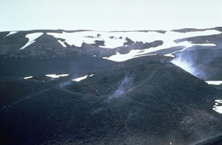 Steam rises in 1967 from a scoria cone along the Vikraborgir crater row, which was formed during an eruption of Askja volcano in 1961. The eruption began on 26 October from a fissure cutting the NE caldera floor. A chain of small scoria cones formed over the eruptive fissure, which fed lava flows that traveled 9.5 km E.
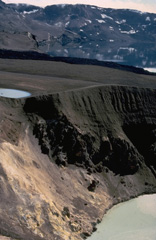 The steep-walled Viti crater in the foreground was formed during an eruption of Askja that began on January 1, 1875. A powerful plinian phase beginning on March 28 was preceded by caldera collapse that continued slowly for several years. Viti ("Hell") crater, now filled by a small lake, was created by phreatic eruptions that followed the plinian explosions.
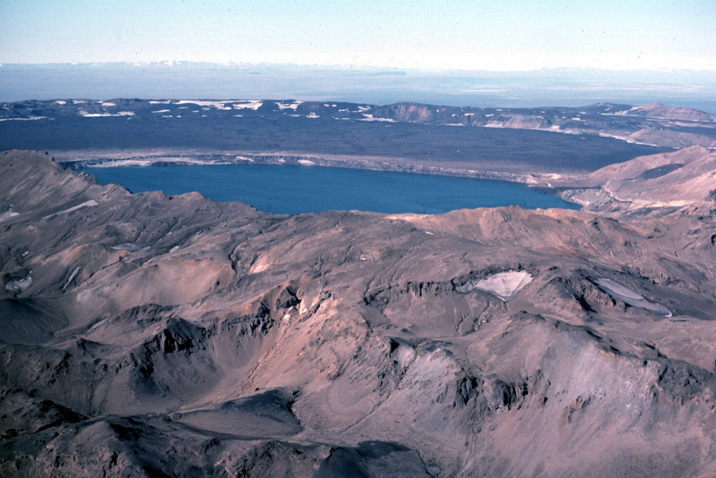
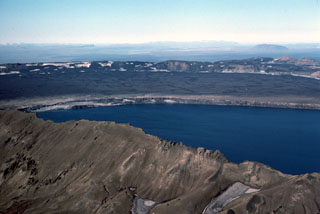 Askja's largest historical eruption occurred in 1875. Subsidence of the caldera continued for 40-50 years after the eruption and resulted in the formation of Askja's inner caldera, now filled by Öskjuvatn lake, seen here from the SE. The flat, lava-covered floor of the main caldera can be seen beyond the lake, encircled by the caldera rim.
 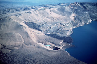 The dark 1921 Batshraun lava flow descends from a vent (left center) on the caldera rim into Öskjuvatn lake across several fault blocks related to caldera subsidence. This aerial view from the northwest shows the small 200-m-wide Viti maar (lower center), which formed during the 1875 eruption. Following slow subsidence of the caldera during and after the 1875 eruption, the depression was filled by the waters of Öskjuvatn lake. During the 1920's, several lava flows erupted from vents surrounding the caldera and flowed into the lake.
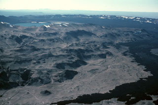 The dark-colored lava flow at the lower right was erupted during 1961 from a vent on the NE side of Askja caldera and flowed about 9.5 km E. The western rim of the ~8-km-diameter main Askja caldera can be seen in the background, rising above its flat, lava-covered floor. The 1961 vents were on the right in this image. The lake at the upper left is Öskjuvatn, which fills Askja's youngest caldera, formed due to the explosive 1875 eruption. The irregular slopes of the Dyngjufjöll massif in the foreground are formed almost entirely by the products of subglacial eruptions.
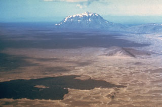
 Askja is a central volcano made up of the Dyngjufjöll massif and at least three calderas, the largest of which is 8 km wide. This view from the SE looks across Öskjuvatn lake within the youngest caldera that formed in 1875 during Askja's largest historical eruption. It truncates a larger caldera, whose wall is seen in the distance above the lava-covered caldera floor. The 100-km-long Askja fissure swarm, which includes the Sveinagjá graben, is also related to the Askja volcanic system.
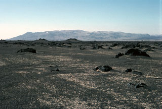 The Askja central volcano, seen here from the north, forms the Dyngjufjöll massif about 20 km N of the Vatnajökull icecap. The massif is mainly composed of subglacial pillow lavas, lava flows, and hyaloclastites, with a broad summit truncated by three overlapping calderas. Much of the Holocene activity has been focused at and around this central massif, but the Askja volcanic system includes fissure swarms extending 170 km N.
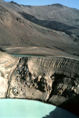 The 200-m-wide Viti maar crater, filled with a turquoise lake, was formed by phreatic explosions following a major Plinian eruption at Askja on 28-29 March 1875. Note the fault cutting the crater wall on the left. The dark lava flow in the background erupted from a vent on the NE caldera wall in 1921 and entered 4.5-km-wide Öskjuvatn lake, out of view to the right.
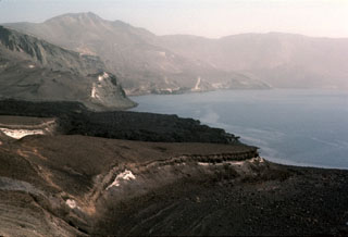 The dark Batshraun lava flow descending from the left into Öskjuvatn lake was erupted during 1921. The lava flow originated from a vent below the NE rim of Askja's central caldera, and flowed over the low rim of the younger 1875 caldera into the lake. The lava flow was the first of several during the 1920's that flowed into the NE, SE, and W sides of Öskjuvatn lake.
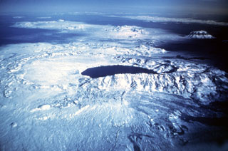 Askja, seen here in an aerial view from the south, is a large central volcano truncated by three overlapping calderas. The youngest caldera, formed during the large 1875 eruption, is filled by Öskjuvatn lake (center). This caldera partially truncates the largest Askja caldera, whose floor forms the flat-surfaced area left of the lake now filled with recent lava. The prominent snow-capped peak on the right is Herðubreið, which has not been active in the Holocene.
The following 2 samples associated with this volcano can be found in the Smithsonian's NMNH Department of Mineral Sciences collections, and may be availble for research (contact the Rock and Ore Collections Manager). Catalog number links will open a window with more information.
| Catalog Number | Sample Description | Lava Source | Collection Date |
|---|---|---|---|
| NMNH 111086 | Basalt | -- | -- |
| NMNH 117551-5 | Obsidian | -- | -- |
| Catalogue of Icelandic Volcanoes (Link to Askja) | The Catalogue of Icelandic Volcanoes is an interactive, web-based tool, containing information on volcanic systems that belong to the active volcanic zones of Iceland. It is a collaboration of the Icelandic Meteorological Office (the state volcano observatory), the Institute of Earth Sciences at the University of Iceland, and the Civil Protection Department of the National Commissioner of the Iceland Police, with contributions from a large number of specialists in Iceland and elsewhere. This official publication is intended to serve as an accurate and up-to-date source of information about active volcanoes in Iceland and their characteristics. The Catalogue forms a part of an integrated volcanic risk assessment project in Iceland GOSVÁ (commenced in 2012), as well as being part of the effort of FUTUREVOLC (2012-2016) on establishing an Icelandic volcano supersite. |
| Copernicus Browser | The Copernicus Browser replaced the Sentinel Hub Playground browser in 2023, to provide access to Earth observation archives from the Copernicus Data Space Ecosystem, the main distribution platform for data from the EU Copernicus missions. |
| MIROVA | Middle InfraRed Observation of Volcanic Activity (MIROVA) is a near real time volcanic hot-spot detection system based on the analysis of MODIS (Moderate Resolution Imaging Spectroradiometer) data. In particular, MIROVA uses the Middle InfraRed Radiation (MIR), measured over target volcanoes, in order to detect, locate and measure the heat radiation sourced from volcanic activity. |
| MODVOLC Thermal Alerts | Using infrared satellite Moderate Resolution Imaging Spectroradiometer (MODIS) data, scientists at the Hawai'i Institute of Geophysics and Planetology, University of Hawai'i, developed an automated system called MODVOLC to map thermal hot-spots in near real time. For each MODIS image, the algorithm automatically scans each 1 km pixel within it to check for high-temperature hot-spots. When one is found the date, time, location, and intensity are recorded. MODIS looks at every square km of the Earth every 48 hours, once during the day and once during the night, and the presence of two MODIS sensors in space allows at least four hot-spot observations every two days. Each day updated global maps are compiled to display the locations of all hot spots detected in the previous 24 hours. There is a drop-down list with volcano names which allow users to 'zoom-in' and examine the distribution of hot-spots at a variety of spatial scales. |
|
WOVOdat
Single Volcano View Temporal Evolution of Unrest Side by Side Volcanoes |
WOVOdat is a database of volcanic unrest; instrumentally and visually recorded changes in seismicity, ground deformation, gas emission, and other parameters from their normal baselines. It is sponsored by the World Organization of Volcano Observatories (WOVO) and presently hosted at the Earth Observatory of Singapore.
GVMID Data on Volcano Monitoring Infrastructure The Global Volcano Monitoring Infrastructure Database GVMID, is aimed at documenting and improving capabilities of volcano monitoring from the ground and space. GVMID should provide a snapshot and baseline view of the techniques and instrumentation that are in place at various volcanoes, which can be use by volcano observatories as reference to setup new monitoring system or improving networks at a specific volcano. These data will allow identification of what monitoring gaps exist, which can be then targeted by remote sensing infrastructure and future instrument deployments. |
| Volcanic Hazard Maps | The IAVCEI Commission on Volcanic Hazards and Risk has a Volcanic Hazard Maps database designed to serve as a resource for hazard mappers (or other interested parties) to explore how common issues in hazard map development have been addressed at different volcanoes, in different countries, for different hazards, and for different intended audiences. In addition to the comprehensive, searchable Volcanic Hazard Maps Database, this website contains information about diversity of volcanic hazard maps, illustrated using examples from the database. This site is for educational purposes related to volcanic hazard maps. Hazard maps found on this website should not be used for emergency purposes. For the most recent, official hazard map for a particular volcano, please seek out the proper institutional authorities on the matter. |
| IRIS seismic stations/networks | Incorporated Research Institutions for Seismology (IRIS) Data Services map showing the location of seismic stations from all available networks (permanent or temporary) within a radius of 0.18° (about 20 km at mid-latitudes) from the given location of Askja. Users can customize a variety of filters and options in the left panel. Note that if there are no stations are known the map will default to show the entire world with a "No data matched request" error notice. |
| UNAVCO GPS/GNSS stations | Geodetic Data Services map from UNAVCO showing the location of GPS/GNSS stations from all available networks (permanent or temporary) within a radius of 20 km from the given location of Askja. Users can customize the data search based on station or network names, location, and time window. Requires Adobe Flash Player. |
| DECADE Data | The DECADE portal, still in the developmental stage, serves as an example of the proposed interoperability between The Smithsonian Institution's Global Volcanism Program, the Mapping Gas Emissions (MaGa) Database, and the EarthChem Geochemical Portal. The Deep Earth Carbon Degassing (DECADE) initiative seeks to use new and established technologies to determine accurate global fluxes of volcanic CO2 to the atmosphere, but installing CO2 monitoring networks on 20 of the world's 150 most actively degassing volcanoes. The group uses related laboratory-based studies (direct gas sampling and analysis, melt inclusions) to provide new data for direct degassing of deep earth carbon to the atmosphere. |
| Large Eruptions of Askja | Information about large Quaternary eruptions (VEI >= 4) is cataloged in the Large Magnitude Explosive Volcanic Eruptions (LaMEVE) database of the Volcano Global Risk Identification and Analysis Project (VOGRIPA). |
| EarthChem | EarthChem develops and maintains databases, software, and services that support the preservation, discovery, access and analysis of geochemical data, and facilitate their integration with the broad array of other available earth science parameters. EarthChem is operated by a joint team of disciplinary scientists, data scientists, data managers and information technology developers who are part of the NSF-funded data facility Integrated Earth Data Applications (IEDA). IEDA is a collaborative effort of EarthChem and the Marine Geoscience Data System (MGDS). |