
The Global Volcanism Program has no activity reports available for Fayal.
The Global Volcanism Program has no Weekly Reports available for Fayal.
The Global Volcanism Program has no Bulletin Reports available for Fayal.
|
|
||||||||||||||||||||||||||
There is data available for 2 confirmed eruptive periods.
1957 Sep 27 - 1958 Oct 24 Confirmed Eruption (Explosive / Effusive) VEI: 2
| Episode 1 | Eruption (Explosive / Effusive) | West flank (Capelinhos) and summit | |||||||||||||||||||||||||||||||||||||||||||||||||||||||||||||||||||||||||||||||||||
|---|---|---|---|---|---|---|---|---|---|---|---|---|---|---|---|---|---|---|---|---|---|---|---|---|---|---|---|---|---|---|---|---|---|---|---|---|---|---|---|---|---|---|---|---|---|---|---|---|---|---|---|---|---|---|---|---|---|---|---|---|---|---|---|---|---|---|---|---|---|---|---|---|---|---|---|---|---|---|---|---|---|---|---|---|
| 1957 Sep 27 - 1958 Oct 24 | Evidence from Observations: Reported | |||||||||||||||||||||||||||||||||||||||||||||||||||||||||||||||||||||||||||||||||||
|
List of 15 Events for Episode 1 at West flank (Capelinhos) and summit
|
||||||||||||||||||||||||||||||||||||||||||||||||||||||||||||||||||||||||||||||||||||
1672 Apr 24 - 1673 Feb 28 Confirmed Eruption (Explosive / Effusive) VEI: 2
| Episode 1 | Eruption (Explosive / Effusive) | West flank | ||||||||||||||||||||||||||||||||||||||||||||||||
|---|---|---|---|---|---|---|---|---|---|---|---|---|---|---|---|---|---|---|---|---|---|---|---|---|---|---|---|---|---|---|---|---|---|---|---|---|---|---|---|---|---|---|---|---|---|---|---|---|---|
| 1672 Apr 24 - 1673 Feb 28 | Evidence from Observations: Reported | ||||||||||||||||||||||||||||||||||||||||||||||||
|
List of 8 Events for Episode 1 at West flank
|
|||||||||||||||||||||||||||||||||||||||||||||||||
This compilation of synonyms and subsidiary features may not be comprehensive. Features are organized into four major categories: Cones, Craters, Domes, and Thermal Features. Synonyms of features appear indented below the primary name. In some cases additional feature type, elevation, or location details are provided.
Synonyms |
||||
| Faial | ||||
Cones |
||||
| Feature Name | Feature Type | Elevation | Latitude | Longitude |
| Canto, Cabeco do | Cone | 346 m | ||
| Capelinhos | Cone | |||
| Carneiro, Monte | Cone | 267 m | ||
| Dos Trinta, Cabeco | Cone | 762 m | ||
| Fogo, Cabeco do | Cone | 570 m | ||
| Funda da Caldeira | Cone | 592 m | ||
| Guia, Monte de | Tuff cone | 145 m | ||
| Pacheco, Cabecos do | Cone | 582 m | ||
| Verde, Cabeco | Cone | 488 m | ||
Craters |
||||
| Feature Name | Feature Type | Elevation | Latitude | Longitude |
| Caldeira | Caldera | 1043 m | 38° 35' 0.00" N | 28° 43' 0.00" W |
Domes |
||||
| Feature Name | Feature Type | Elevation | Latitude | Longitude |
| Castelo Branco | Dome | |||
Thermal |
||||
| Feature Name | Feature Type | Elevation | Latitude | Longitude |
| Varadouro | Thermal | |||
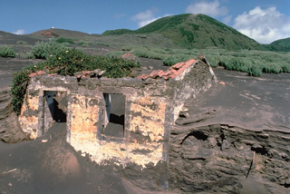 Accumulated thin layers of ashfall deposits reach nearly to the roofline at both gable ends of a house on the western tip of Fayal Island. Repetitive, long-term ashfall during a 1957-58 eruption built an offshore cinder cone that added 1 km to the island's western peninsula.
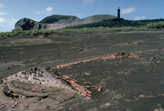 A submarine eruption that began off the western coast of Fayal Island in 1957 produced heavy ashfall that buried houses, such as the one in the foreground. The new submarine vent built a pyroclastic cone (upper left) that was eventually connected to the mainland. Extensive ashfall partially buried the Capelinhos lighthouse (upper right), which had been located on the western shoreline of Fayal Island.
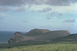 A pyroclastic cone initially built by submarine eruptions during 1957-58 now forms a peninsula at the western tip of Fayal Island. The top of the lighthouse, which was located along the former shoreline, is visible at the lower left-center of the photo. Heavy ashfall from the eruption covered several houses and partially buried the lighthouse. Within the first two weeks of the eruption, an 800-m-wide island was built up to 100 m above sea level.
 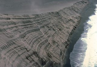 The new pyroclastic cone formed during the 1957-58 Capelinhos eruption has been extensively eroded by the sea, exposing this cross-section of the cone. The thick stack of tephra layers formed by fallout of pyroclastic material during individual eruptive pulses illustrates the process by which pyroclastic cones grow. Initial eruptions were submarine, but these tephra layers were formed by subaerial eruptions after the vent rose above sea level.
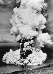 A column of ash and steam rises above a new submarine vent off the western coast of Fayal Island in early October 1957. Horizontally traveling base surges form a ring at the base of the eruption column. Explosive eruptions began on September 27 and formed a small island that eventually was joined to the main island, partially burying the Capelinhos lighthouse, which is visible on the center shoreline (bottom). Lava effusion was continuous for the last five months of the 13-month eruption.
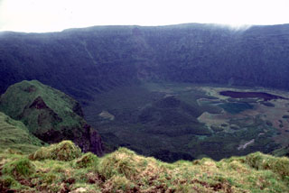 Fayal volcano is capped by a 2-km-wide, 400-m-deep summit caldera, seen here from its southern rim. A small pyroclastic cone (center) and a dark lake (right) can be seen on the floor of the caldera. The caldera was formed incrementally, beginning with a large eruption about 1,000 years ago. Thick airfall-pumice and pyroclastic-flow deposits related to this eruption cover the island.
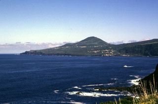 The gentle slope along the right horizon is covered by lava flows that formed during the 1672-73 eruption. This eruption occurred along a WNW-ESE-trending ridge forming a wedge-shaped peninsula at the western tip of the island. Cabeço Verde (center), seen here from the SE, is one of a chain of pyroclastic cones that were constructed along the axis of the peninsula during the eruption. The most recent eruption at Fayal started in 1957 and occurred at the end of this peninsula.
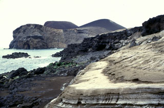 The eroded pyroclastic cone at the left, now forming the western tip of Fayal Island, was constructed during the 1957-58 Capelinhos eruption. Submarine eruptions formed an island that was later joined to the mainland, creating a 1-km-wide peninsula. Wave erosion soon truncated the sides of the new cone, forming the steep south-facing cliffs seen here. Beach erosion in the foreground exposes light-colored ashfall deposits from the eruption.
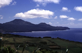 Cabeço Verde (left center) and Cabeço do Canto (center) are two pyroclastic cones along a linear chain of volcanoes that form the western peninsula of Fayal Island. Lava flows from these cones flowed into the sea on the northern and southern coasts during the 1672-73 eruption.
 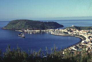 The Monte da Guia tuff cone forms a backdrop to the harbor of Horta, the largest town on the island of Fayal. The cone was formed by phreatomagmatic eruptions just off the SE tip of the island and is now connected to Fayal by a low narrow peninsula. It is one of a cluster of cones on the lower SE flank. These cones and an associated basaltic lava field form the late Pleistocene Almoxarife Formation.
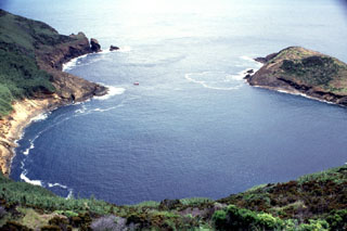 The crater of Monte da Guia tuff cone at the SE tip of Fayal Island has been breached by the sea, forming a circular bay measuring about 500 m long. This view looks out to sea from the NW rim of the cone, which was formed by phreatomagmatic eruptions produced when magma encountered water along the coast. A small boat used by divers provides scale off the headland at left center.
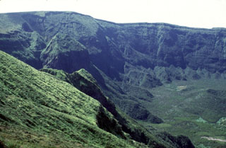 The steep vegetated northwest wall of the 2-km-wide summit caldera of Fayal volcano rises about 400 m above the caldera floor. A small pyroclastic cone is visible at the lower right. It is thought that this caldera formed in stages, beginning with a large explosive eruption about 1,000 years ago.
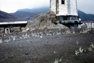 Pyroclastic surge, or base surge deposits from the 1957 phreatomagmatic Capelinhos eruption lap up against a lighthouse near the western coast of Fayal Island in the Azores. Pyroclastic surges produced by magma-water interaction during the Surtseyan eruption nearly buried the lower floor of the lighthouse building. The initially submarine eruption began off the western tip of Fayal, forming a small island that was eventually joined to the main island.
 The following 8 samples associated with this volcano can be found in the Smithsonian's NMNH Department of Mineral Sciences collections, and may be availble for research (contact the Rock and Ore Collections Manager). Catalog number links will open a window with more information.
| Catalog Number | Sample Description | Lava Source | Collection Date |
|---|---|---|---|
| NMNH 109363 | Plagioclase Basalt | -- | -- |
| NMNH 116691-13 | Volcanic Bomb | -- | 1 Aug 1980 |
| NMNH 116691-14 | Volcanic Bomb | -- | 1 Aug 1980 |
| NMNH 116691-16 | Volcanic Bomb | -- | 1 Aug 1980 |
| NMNH 117254-112 | Lava | -- | -- |
| NMNH 72951 | Basalt | -- | -- |
| NMNH 72952-1 | Basalt | -- | -- |
| NMNH 72952-2 | Basalt | -- | -- |
| Copernicus Browser | The Copernicus Browser replaced the Sentinel Hub Playground browser in 2023, to provide access to Earth observation archives from the Copernicus Data Space Ecosystem, the main distribution platform for data from the EU Copernicus missions. |
| MIROVA | Middle InfraRed Observation of Volcanic Activity (MIROVA) is a near real time volcanic hot-spot detection system based on the analysis of MODIS (Moderate Resolution Imaging Spectroradiometer) data. In particular, MIROVA uses the Middle InfraRed Radiation (MIR), measured over target volcanoes, in order to detect, locate and measure the heat radiation sourced from volcanic activity. |
| MODVOLC Thermal Alerts | Using infrared satellite Moderate Resolution Imaging Spectroradiometer (MODIS) data, scientists at the Hawai'i Institute of Geophysics and Planetology, University of Hawai'i, developed an automated system called MODVOLC to map thermal hot-spots in near real time. For each MODIS image, the algorithm automatically scans each 1 km pixel within it to check for high-temperature hot-spots. When one is found the date, time, location, and intensity are recorded. MODIS looks at every square km of the Earth every 48 hours, once during the day and once during the night, and the presence of two MODIS sensors in space allows at least four hot-spot observations every two days. Each day updated global maps are compiled to display the locations of all hot spots detected in the previous 24 hours. There is a drop-down list with volcano names which allow users to 'zoom-in' and examine the distribution of hot-spots at a variety of spatial scales. |
|
WOVOdat
Single Volcano View Temporal Evolution of Unrest Side by Side Volcanoes |
WOVOdat is a database of volcanic unrest; instrumentally and visually recorded changes in seismicity, ground deformation, gas emission, and other parameters from their normal baselines. It is sponsored by the World Organization of Volcano Observatories (WOVO) and presently hosted at the Earth Observatory of Singapore.
GVMID Data on Volcano Monitoring Infrastructure The Global Volcano Monitoring Infrastructure Database GVMID, is aimed at documenting and improving capabilities of volcano monitoring from the ground and space. GVMID should provide a snapshot and baseline view of the techniques and instrumentation that are in place at various volcanoes, which can be use by volcano observatories as reference to setup new monitoring system or improving networks at a specific volcano. These data will allow identification of what monitoring gaps exist, which can be then targeted by remote sensing infrastructure and future instrument deployments. |
| Volcanic Hazard Maps | The IAVCEI Commission on Volcanic Hazards and Risk has a Volcanic Hazard Maps database designed to serve as a resource for hazard mappers (or other interested parties) to explore how common issues in hazard map development have been addressed at different volcanoes, in different countries, for different hazards, and for different intended audiences. In addition to the comprehensive, searchable Volcanic Hazard Maps Database, this website contains information about diversity of volcanic hazard maps, illustrated using examples from the database. This site is for educational purposes related to volcanic hazard maps. Hazard maps found on this website should not be used for emergency purposes. For the most recent, official hazard map for a particular volcano, please seek out the proper institutional authorities on the matter. |
| IRIS seismic stations/networks | Incorporated Research Institutions for Seismology (IRIS) Data Services map showing the location of seismic stations from all available networks (permanent or temporary) within a radius of 0.18° (about 20 km at mid-latitudes) from the given location of Fayal. Users can customize a variety of filters and options in the left panel. Note that if there are no stations are known the map will default to show the entire world with a "No data matched request" error notice. |
| UNAVCO GPS/GNSS stations | Geodetic Data Services map from UNAVCO showing the location of GPS/GNSS stations from all available networks (permanent or temporary) within a radius of 20 km from the given location of Fayal. Users can customize the data search based on station or network names, location, and time window. Requires Adobe Flash Player. |
| DECADE Data | The DECADE portal, still in the developmental stage, serves as an example of the proposed interoperability between The Smithsonian Institution's Global Volcanism Program, the Mapping Gas Emissions (MaGa) Database, and the EarthChem Geochemical Portal. The Deep Earth Carbon Degassing (DECADE) initiative seeks to use new and established technologies to determine accurate global fluxes of volcanic CO2 to the atmosphere, but installing CO2 monitoring networks on 20 of the world's 150 most actively degassing volcanoes. The group uses related laboratory-based studies (direct gas sampling and analysis, melt inclusions) to provide new data for direct degassing of deep earth carbon to the atmosphere. |
| Large Eruptions of Fayal | Information about large Quaternary eruptions (VEI >= 4) is cataloged in the Large Magnitude Explosive Volcanic Eruptions (LaMEVE) database of the Volcano Global Risk Identification and Analysis Project (VOGRIPA). |
| EarthChem | EarthChem develops and maintains databases, software, and services that support the preservation, discovery, access and analysis of geochemical data, and facilitate their integration with the broad array of other available earth science parameters. EarthChem is operated by a joint team of disciplinary scientists, data scientists, data managers and information technology developers who are part of the NSF-funded data facility Integrated Earth Data Applications (IEDA). IEDA is a collaborative effort of EarthChem and the Marine Geoscience Data System (MGDS). |

