Global Volcanism Program | Image GVP-07987
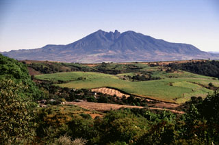
A SE-trending chain of scoria cones extends beyond the flank of Sangangüey volcano into the Tepic basin. Cerro el Molcajete, the flat-topped cone to the right, shares the name of Volcán el Molcajete on the NW flank of Sangangüey. This NW-SE-trending alignment of Pleistocene basalt and mugearite scoria cones is seen here from the south across farmlands near the village of El Limón.
Photo by Jim Luhr, 1999 (Smithsonian Institution).
![]() This image is made available under the Public Domain Dedication CC0 license, but proper attribution is appreciated.
This image is made available under the Public Domain Dedication CC0 license, but proper attribution is appreciated.
Galleries: Scoria Cones
Keywords: scoria cone
Sangangüey