Global Volcanism Program | Image GVP-11119

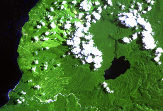
Lake Hargy (lower right) lies in the SE corner of the 10 x 12 km wide Hargy caldera. The Lobu River drains the lake through a notch in the northern caldera rim. The post-caldera cone of Galloseulo lies beneath the large cloud bank in the center of the image, about halfway from the lake to the Bismarck Sea. The Toiru River cuts across the bottom of the image. Small eruptions have taken place at Galloseulo over the past 7,000 years, the last occurring about 1,000 years ago.
NASA Landsat image, 2000 (courtesy of Hawaii Synergy Project, Univ. of Hawaii Institute of Geophysics & Planetology).
![]() This image is made available as a Public Domain Work, but proper attribution is appreciated.
This image is made available as a Public Domain Work, but proper attribution is appreciated.
Hargy