Global Volcanism Program | Image GVP-11176

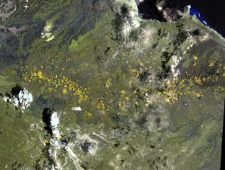
The long chain of pyroclastic cones and lava flows extending E-W across this Landsat image is the Assab volcanic field near the Red Sea coast in southern Eritrea. This spectacular range of basaltic cinder cones and associated lava flows covers a 55 x 90 km area, and flows reached the Red Sea along a broad front. The vents were constructed along a broad E-W-trending line that extends to the coastal city of Assab, out of view to right.
NASA Landsat image, 1999 (courtesy of Hawaii Synergy Project, Univ. of Hawaii Institute of Geophysics & Planetology).
![]() This image is made available as a Public Domain Work, but proper attribution is appreciated.
This image is made available as a Public Domain Work, but proper attribution is appreciated.
Assab Volcanic Field