Global Volcanism Program | Image GVP-11217

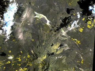
The yellow-colored pyroclastic cones at the upper right lie along the western part of the Gufa volcanic field, which extends from the Djibouti border into Eritrea (upper right). These basaltic scoria cones and lava flows are aligned in an E-W direction NE of Mousa Alli volcano, a large stratovolcano that is visible at the bottom center of this NASA Landsat image. A second E-W-trending chain of cones, not visible in this image, is located to the north of the principal chain in Eritrea and fed long lava flows that descend in the direction of the Red Sea.
NASA Landsat image, 1999 (courtesy of Hawaii Synergy Project, Univ. of Hawaii Institute of Geophysics & Planetology).
![]() This image is made available as a Public Domain Work, but proper attribution is appreciated.
This image is made available as a Public Domain Work, but proper attribution is appreciated.
Gufa