Recently Published Bulletin Reports
Erebus (Antarctica) Lava lake remains active; most thermal alerts recorded since 2019
Rincon de la Vieja (Costa Rica) Frequent phreatic explosions during July-December 2023
Bezymianny (Russia) Explosion on 18 October 2023 sends ash plume 8 km high; lava flows and incandescent avalanches
Kilauea (United States) Low-level lava effusions in the lava lake at Halema’uma’u during July-December 2022
Nyamulagira (DR Congo) Lava flows and thermal activity during May-October 2023
Bagana (Papua New Guinea) Explosions, ash plumes, ashfall, and lava flows during April-September 2023
Mayon (Philippines) Lava flows, pyroclastic flows, ash emissions, and seismicity during April-September 2023
Nishinoshima (Japan) Eruption plumes and gas-and-steam plumes during May-August 2023
Krakatau (Indonesia) White gas-and-steam plumes and occasional ash plumes during May-August 2023
Villarrica (Chile) Strombolian activity, gas-and-ash emissions, and crater incandescence during April-September 2023
Merapi (Indonesia) Frequent incandescent avalanches during April-September 2023
Ebeko (Russia) Moderate explosive activity with ash plumes continued during June-November 2023
Erebus (Antarctica) — January 2024  Cite this Report
Erebus
Antarctica
77.53°S, 167.17°E; summit elev. 3794 m
All times are local (unless otherwise noted)
Lava lake remains active; most thermal alerts recorded since 2019
The lava lake in the summit crater of Erebus has been active since at least 1972. Located in Antarctica overlooking the McMurdo Station on Ross Island, it is the southernmost active volcano on the planet. Because of the remote location, activity is primarily monitored by satellites. This report covers activity during 2023.
The number of thermal alerts recorded by the Hawai'i Institute of Geophysics and Planetology’s MODVOLC Thermal Alerts System increased considerably in 2023 compared to the years 2020-2022 (table 9). In contrast to previous years, the MODIS instruments aboard the Aqua and Terra satellites captured data from Erebus every month during 2023. Consistent with previous years, the lowest number of anomalous pixels were recorded in January, November, and December.
Table 9. Number of monthly MODIS-MODVOLC thermal alert pixels recorded at Erebus during 2017-2023. See BGVN 42:06 for data from 2000 through 2016. The table was compiled using data provided by the HIGP – MODVOLC Thermal Alerts System.
| Year |
Jan |
Feb |
Mar |
Apr |
May |
Jun |
Jul |
Aug |
Sep |
Oct |
Nov |
Dec |
SUM |
| 2017 |
0 |
21 |
9 |
0 |
0 |
1 |
11 |
61 |
76 |
52 |
0 |
3 |
234 |
| 2018 |
0 |
21 |
58 |
182 |
55 |
17 |
137 |
172 |
103 |
29 |
0 |
0 |
774 |
| 2019 |
2 |
21 |
162 |
151 |
55 |
56 |
75 |
53 |
29 |
19 |
1 |
0 |
624 |
| 2020 |
0 |
2 |
16 |
18 |
4 |
4 |
1 |
3 |
18 |
3 |
1 |
6 |
76 |
| 2021 |
0 |
9 |
1 |
0 |
2 |
56 |
46 |
47 |
35 |
52 |
5 |
3 |
256 |
| 2022 |
1 |
13 |
55 |
22 |
15 |
32 |
39 |
19 |
31 |
11 |
0 |
0 |
238 |
| 2023 |
2 |
33 |
49 |
82 |
41 |
32 |
70 |
64 |
42 |
17 |
5 |
11 |
448 |
Sentinel-2 infrared images showed one or two prominent heat sources within the summit crater, accompanied by adjacent smaller sources, similar to recent years (see BGVN 46:01, 47:02, and 48:01). A unique image was obtained on 25 November 2023 by the OLI-2 (Operational Land Imager-2) on Landsat 9, showing the upper part of the volcano surrounded by clouds (figure 32).
Geologic Background. Mount Erebus, the world's southernmost historically active volcano, overlooks the McMurdo research station on Ross Island. It is the largest of three major volcanoes forming the crudely triangular Ross Island. The summit of the dominantly phonolitic volcano has been modified by one or two generations of caldera formation. A summit plateau at about 3,200 m elevation marks the rim of the youngest caldera, which formed during the late-Pleistocene and within which the modern cone was constructed. An elliptical 500 x 600 m wide, 110-m-deep crater truncates the summit and contains an active lava lake within a 250-m-wide, 100-m-deep inner crater; other lava lakes are sometimes present. The glacier-covered volcano was erupting when first sighted by Captain James Ross in 1841. Continuous lava-lake activity with minor explosions, punctuated by occasional larger Strombolian explosions that eject bombs onto the crater rim, has been documented since 1972, but has probably been occurring for much of the volcano's recent history.
Information Contacts: Hawai'i Institute of Geophysics and Planetology (HIGP) - MODVOLC Thermal Alerts System, School of Ocean and Earth Science and Technology (SOEST), Univ. of Hawai'i, 2525 Correa Road, Honolulu, HI 96822, USA (URL: http://modis.higp.hawaii.edu/); Copernicus Browser, Copernicus Data Space Ecosystem, European Space Agency (URL: https://dataspace.copernicus.eu/browser/); NASA Earth Observatory, EOS Project Science Office, NASA Goddard Space Flight Center, Goddard, Maryland, USA (URL: https://earthobservatory.nasa.gov/images/152134/erebus-breaks-through).
Rincon de la Vieja (Costa Rica) — January 2024 Cite this Report
Rincon de la Vieja
Costa Rica
10.83°N, 85.324°W; summit elev. 1916 m
All times are local (unless otherwise noted)
Frequent phreatic explosions during July-December 2023
Rincón de la Vieja is a volcanic complex in Costa Rica with a hot convecting acid lake that exhibits frequent weak phreatic explosions, gas-and-steam emissions, and occasional elevated sulfur dioxide levels (BGVN 45:10, 46:03, 46:11). The current eruption period began June 2021. This report covers activity during July-December 2023 and is based on weekly bulletins and occasional daily reports from the Observatorio Vulcanologico Sismologica de Costa Rica-Universidad Nacional (OVSICORI-UNA).
Numerous weak phreatic explosions continued during July-December 2023, along with gas-and-steam emissions and plumes that rose as high as 3 km above the crater rim. Many weekly OVSICORI-UNA bulletins included the previous week's number of explosions and emissions (table 9). For many explosions, the time of explosion was given (table 10). Frequent seismic activity (long-period earthquakes, volcano-tectonic earthquakes, and tremor) accompanied the phreatic activity.
Table 9. Number of reported weekly phreatic explosions and gas-and-steam emissions at Rincón de la Vieja, July-December 2023. Counts are reported for the week before the Weekly Bulletin date; not all reports included these data. Courtesy of OVSICORI-UNA.
| OVSICORI Weekly Bulletin |
Number of explosions |
Number of emissions |
| 28 Jul 2023 |
6 |
14 |
| 4 Aug 2023 |
10 |
12 |
| 1 Sep 2023 |
13 |
11 |
| 22 Sep 2023 |
12 |
13 |
| 29 Sep 2023 |
6 |
11 |
| 6 Oct 2023 |
12 |
5 |
| 13 Oct 2023 |
7 |
9 |
| 20 Oct 2023 |
1 |
15 |
| 27 Oct 2023 |
3 |
23 |
| 3 Nov 2023 |
3 |
10 |
| 17 Nov 2023 |
0 |
Some |
| 24 Nov 2023 |
0 |
14 |
| 8 Dec 2023 |
4 |
16 |
| 22 Dec 2023 |
8 |
18 |
Table 10. Summary of activity at Rincón de la Vieja during July-December 2023. Weak phreatic explosions and gas emissions are noted where the time of explosion was indicated in the weekly or daily bulletins. Height of plumes or emissions are distance above the crater rim. Courtesy of OVSICORI-UNA.
| Date |
Time |
Description of Activity |
| 1 Jul 2023 |
0156 |
Explosion. |
| 2 Jul 2023 |
0305 |
Explosion. |
| 4 Jul 2023 |
0229, 0635 |
Event at 0635 produced a gas-and-steam plume that rose 700 m and drifted W; seen by residents in Liberia (21 km SW). |
| 9 Jul 2023 |
1843 |
Explosion. |
| 21 Jul 2023 |
0705 |
Explosion. |
| 26 Jul 2023 |
1807 |
Explosion. |
| 28 Jul 2023 |
0802 |
Explosion generated a gas-and-steam plume that rose 500 m. |
| 30 Jul 2023 |
1250 |
Explosion. |
| 31 Jul 2023 |
2136 |
Explosion. |
| 11 Aug 2023 |
0828 |
Explosion. |
| 18 Aug 2023 |
1304 |
Explosion. |
| 21 Aug 2023 |
1224 |
Explosion generated gas-and-steam plumes rose 500-600 m. |
| 22 Aug 2023 |
0749 |
Explosion generated gas-and-steam plumes rose 500-600 m. |
| 24 Aug 2023 |
1900 |
Explosion. |
| 25 Aug 2023 |
0828 |
Event produced a steam-and-gas plume that rose 3 km and drifted NW. |
| 27-28 Aug 2023 |
0813 |
Four small events; the event at 0813 on 28 August lasted two minutes and generated a steam-and-gas plume that rose 2.5 km. |
| 1 Sep 2023 |
1526 |
Explosion generated plume that rose 2 km and ejected material onto the flanks. |
| 2-3 Sep 2023 |
- |
Small explosions detected in infrasound data. |
| 4 Sep 2023 |
1251 |
Gas-and-steam plume rose 1 km and drifted W. |
| 7 Nov 2023 |
1113 |
Explosion. |
| 8 Nov 2023 |
0722 |
Explosion. |
| 12 Nov 2023 |
0136 |
Small gas emissions. |
| 14 Nov 2023 |
0415 |
Small gas emissions. |
According to OVSICORI-UNA, during July-October the average weekly sulfur dioxide (SO2) flux ranged from 68 to 240 tonnes/day. However, in mid-November the flux increased to as high as 334 tonnes/day, the highest value measured in recent years. The high SO2 flux in mid-November was also detected by the TROPOMI instrument on the Sentinel-5P satellite (figure 43).
Geologic Background. Rincón de la Vieja, the largest volcano in NW Costa Rica, is a remote volcanic complex in the Guanacaste Range. The volcano consists of an elongated, arcuate NW-SE-trending ridge constructed within the 15-km-wide early Pleistocene Guachipelín caldera, whose rim is exposed on the south side. Sometimes known as the "Colossus of Guanacaste," it has an estimated volume of 130 km3 and contains at least nine major eruptive centers. Activity has migrated to the SE, where the youngest-looking craters are located. The twin cone of Santa María volcano, the highest peak of the complex, is located at the eastern end of a smaller, 5-km-wide caldera and has a 500-m-wide crater. A Plinian eruption producing the 0.25 km3 Río Blanca tephra about 3,500 years ago was the last major magmatic eruption. All subsequent eruptions, including numerous historical eruptions possibly dating back to the 16th century, have been from the prominent active crater containing a 500-m-wide acid lake located ENE of Von Seebach crater.
Information Contacts: Observatorio Vulcanológico Sismológica de Costa Rica-Universidad Nacional (OVSICORI-UNA), Apartado 86-3000, Heredia, Costa Rica (URL: http://www.ovsicori.una.ac.cr/); NASA Global Sulfur Dioxide Monitoring Page, Atmospheric Chemistry and Dynamics Laboratory, NASA Goddard Space Flight Center (NASA/GSFC), 8800 Greenbelt Road, Goddard MD 20771, USA (URL: https://so2.gsfc.nasa.gov/).
Bezymianny (Russia) — November 2023 Cite this Report
Bezymianny
Russia
55.972°N, 160.595°E; summit elev. 2882 m
All times are local (unless otherwise noted)
Explosion on 18 October 2023 sends ash plume 8 km high; lava flows and incandescent avalanches
Bezymianny, located on Russia’s Kamchatka Peninsula, has had eruptions since 1955 characterized by dome growth, explosions, pyroclastic flows, ash plumes, and ashfall. Activity during November 2022-April 2023 included gas-and-steam emissions, lava dome collapses generating avalanches, and persistent thermal activity. Similar eruptive activity continued from May through October 2023, described here based on information from weekly and daily reports of the Kamchatka Volcano Eruptions Response Team (KVERT), notices from Tokyo VAAC (Volcanic Ash Advisory Center), and from satellite data.
Overall activity decreased after the strong period of activity in late March through April 2023, which included ash explosions during 29 March and 7-8 April 2023 that sent plumes as high as 10-12 km altitude, along with dome growth and lava flows (BGVN 48:05). This reduced activity can be seen in the MIROVA thermal detection system graph (figure 56), which was consistent with data from the MODVOLC thermal detection system and with Sentinel-2 satellite images that showed persistent hotspots in the summit crater when conditions allowed observations. A renewed period of strong activity began in mid-October 2023.
Activity increased significantly on 17 October 2023 when large collapses began during 0700-0830 on the E flanks of the lava dome and continued to after 0930 the next day (figure 57). Ash plumes rose to an altitude of 4.5-5 km, extending 220 km NNE by 18 October. A large explosion at 1630 on 18 October produced an ash plume that rose to an altitude of 11 km (8 km above the summit) and drifted NNE and then NW, extending 900 km NW within two days at an altitude of 8 km. Minor ashfall was noted in Kozyrevsk (45 km WNW). At 0820 on 20 October an ash plume was identified in satellite images drifting 100 km ENE at altitudes of 4-4.5 km.
Lava flows and hot avalanches from the dome down the SE flank continued over the next few days, including 23 October when clear conditions allowed good observations (figures 58 and 59). A large thermal anomaly was observed over the volcano through 24 October, and in the summit crater on 30 October (figure 60). Strong fumarolic activity continued, with numerous avalanches and occasional incandescence. By the last week of October, volcanic activity had decreased to a level consistent with that earlier in the reporting period.
Aviation warnings were frequently updated during 17-20 October. KVERT issued a Volcano Observatory Notice for Aviation (VONA) on 17 October at 1419 and 1727 (0219 and 0527 UTC) raising the Aviation Color Code (ACC) from Yellow to Orange (second highest level). The next day, KVERT issued a VONA at 1705 (0505 UTC) raising the ACC to Red (highest level) but lowered it back to Orange at 2117 (0917 UTC). After another decrease to Yellow and back to Orange, the ACC was reduced to Yellow on 20 October at 1204 (0004 UTC). In addition, the Tokyo VAAC issued a series of Volcanic Ash Advisories beginning on 16 October and continuing through 30 October.
Geologic Background. The modern Bezymianny, much smaller than its massive neighbors Kamen and Kliuchevskoi on the Kamchatka Peninsula, was formed about 4,700 years ago over a late-Pleistocene lava-dome complex and an edifice built about 11,000-7,000 years ago. Three periods of intensified activity have occurred during the past 3,000 years. The latest period, which was preceded by a 1,000-year quiescence, began with the dramatic 1955-56 eruption. This eruption, similar to that of St. Helens in 1980, produced a large open crater that was formed by collapse of the summit and an associated lateral blast. Subsequent episodic but ongoing lava-dome growth, accompanied by intermittent explosive activity and pyroclastic flows, has largely filled the 1956 crater.
Information Contacts: Kamchatka Volcanic Eruptions Response Team (KVERT), Far Eastern Branch, Russian Academy of Sciences, 9 Piip Blvd., Petropavlovsk-Kamchatsky, 683006, Russia (URL: http://www.kscnet.ru/ivs/kvert/); Kamchatka Volcanological Station, Kamchatka Branch of Geophysical Survey, (KB GS RAS), Klyuchi, Kamchatka Krai, Russia (URL: http://volkstat.ru/); Tokyo Volcanic Ash Advisory Center (VAAC), 1-3-4 Otemachi, Chiyoda-ku, Tokyo 100-8122, Japan (URL: http://ds.data.jma.go.jp/svd/vaac/data/); Hawai'i Institute of Geophysics and Planetology (HIGP) - MODVOLC Thermal Alerts System, School of Ocean and Earth Science and Technology (SOEST), Univ. of Hawai'i, 2525 Correa Road, Honolulu, HI 96822, USA (URL: http://modis.higp.hawaii.edu/); MIROVA (Middle InfraRed Observation of Volcanic Activity), a collaborative project between the Universities of Turin and Florence (Italy) supported by the Centre for Volcanic Risk of the Italian Civil Protection Department (URL: http://www.mirovaweb.it/); Copernicus Browser, Copernicus Data Space Ecosystem, European Space Agency (URL: https://dataspace.copernicus.eu/browser/).chr
Kilauea (United States) — January 2023 Cite this Report
Kilauea
United States
19.421°N, 155.287°W; summit elev. 1222 m
All times are local (unless otherwise noted)
Low-level lava effusions in the lava lake at Halema’uma’u during July-December 2022
Kīlauea is the southeastern-most volcano in Hawaii and overlaps the E flank of the Mauna Loa volcano. Its East Rift Zone (ERZ) has been intermittently active for at least 2,000 years. An extended eruption period began in January 1983 and was characterized by open lava lakes and lava flows from the summit caldera and the East Rift Zone. During May 2018 magma migrated into the Lower East Rift Zone (LERZ) and opened 24 fissures along a 6-km-long NE-trending fracture zone that produced lava flows traveling in multiple directions. As lava emerged from the fissures, the lava lake at Halema'uma'u drained and explosions sent ash plumes to several kilometers altitude (BGVN 43:10).
The current eruption period started during September 2021 and has recently been characterized by lava effusions, spatter, and sulfur dioxide emissions in the active Halema’uma’u lava lake (BGVN 47:08). Lava effusions, some spatter, and sulfur dioxide emissions have continued during this reporting period of July through December 2022 using daily reports, volcanic activity notices, and abundant photo, map, and video data from the US Geological Survey's (USGS) Hawaiian Volcano Observatory (HVO).
Summary of activity during July-December 2022. Low-level effusions have continued at the western vent of the Halema’uma’u crater during July through early December 2022. Occasional weak ooze-outs (also called lava break outs) would occur along the margins of the crater floor. The overall level of the active lava lake throughout the reporting period gradually increased due to infilling, however it stagnated in mid-September (table 13). During September through November, activity began to decline, though lava effusions persisted at the western vent. By 9 December, the active part of the lava lake had completely crusted over, and incandescence was no longer visible.
Table 13. Summary of measurements taken during overflights at Kīlauea that show a gradual increase in the active lava lake level and the volume of lava effused since 29 September 2021. Lower activity was reported during September-October. Data collected during July-December 2022. Courtesy of HVO.
| Date: |
Level of the active lava lake (m): |
Cumulative volume of lava effused (million cubic meters): |
| 7 Jul 2022 |
130 |
95 |
| 19 Jul 2022 |
133 |
98 |
| 4 Aug 2022 |
136 |
102 |
| 16 Aug 2022 |
137 |
104 |
| 12 Sep 2022 |
143 |
111 |
| 5 Oct 2022 |
143 |
111 |
| 28 Oct 2022 |
143 |
111 |
Activity during July 2022. Lava effusions were reported from the western vent in the Halema’uma’u crater, along with occasional weak ooze-outs along the margins of the crater floor. The height of the lava lake was variable due to deflation-inflation tilt events; for example, the lake level dropped approximately 3-4 m during a summit deflation-inflation event reported on 1 July. Webcam images taken during the night of 6-12 July showed intermittent low-level spattering at the western vent that rose less than 10 m above the vent (figure 519). Measurements made during an overflight on 7 July indicated that the crater floor was infilled about 130 m and that 95 million cubic meters of lava had been effused since 29 September 2021. A single, relatively small lava ooze-out was active to the S of the lava lake. Around midnight on 8 July there were two brief periods of lava overflow onto the lake margins. On 9 July lava ooze-outs were reported near the SE and NE edges of the crater floor and during 10-11 July they occurred near the E, NE, and NW edges. On 16 July crater incandescence was reported, though the ooze-outs and spattering were not visible. On 18 July overnight webcam images showed incandescence in the western vent complex and two ooze-outs were reported around 0000 and 0200 on 19 July. By 0900 there were active ooze-outs along the SW edge of the crater floor. Measurements made from an overflight on 19 July indicated that the crater floor was infilled about 133 m and 98 million cubic meters of lava had erupted since 29 September 2021 (figure 520). On 20 July around 1600 active ooze-outs were visible along the N edge of the crater, which continued through the next day. Extensive ooze-outs occurred along the W margin during 24 July until 1900; on 26 July minor ooze-outs were noted along the N margin. Minor spattering was visible on 29 July along the E margin of the lake. The sulfur dioxide emission rates ranged 650-2,800 tons per day (t/d), the higher of which was measured on 8 July (figure 519).
Activity during August 2022. The eruption continued in the Halema’uma’u crater at the western vent. According to HVO the lava in the active lake remained at the level of the bounding levees. Occasional minor ooze-outs were observed along the margins of the crater floor. Strong nighttime crater incandescence was visible after midnight on 6 August over the western vent cone. During 6-7 August scattered small lava lobes were active along the crater floor and incandescence persisted above the western vent through 9 August. During 7-9 August HVO reported a single lava effusion source was active along the NW margin of the crater floor. Measurements from an overflight on 4 August indicated that the crater floor was infilled about 136 m total and that 102 million cubic meters of lava had been erupted since the start of the eruption. Lava breakouts were reported along the N, NE, E, S, and W margins of the crater during 10-16 August. Another overflight survey conducted on 16 August indicated that the crater floor infilled about 137 m and 104 million cubic meters of lava had been erupted since September 2021. Measured sulfur dioxide emissions rates ranged 1,150-2,450 t/d, the higher of which occurred on 8 August.
Activity during September 2022. During September, lava effusion continued from the western vent into the active lava lake and onto the crater floor. Intermittent minor ooze-outs were reported through the month. A small ooze-out was visible on the W crater floor margin at 0220 on 2 September, which showed decreasing surface activity throughout the day, but remained active through 3 September. On 3 September around 1900 a lava outbreak occurred along the NW margin of the crater floor but had stopped by the evening of 4 September. Field crews monitoring the summit lava lake on 9 September observed spattering on the NE margin of the lake that rose no higher than 10 m, before falling back onto the lava lake crust (figure 521). Overflight measurements on 12 September indicated that the crater floor was infilled a total of 143 m and 111 million cubic meters of lava had been erupted since September 2021. Extensive breakouts in the W and N part of the crater floor were reported at 1600 on 20 September and continued into 26 September. The active part of the lava lake dropped by 10 m while other parts of the crater floor dropped by several meters. Summit tiltmeters recorded a summit seismic swarm of more than 80 earthquakes during 1500-1800 on 21 September, which occurred about 1.5 km below Halema’uma’u; a majority of these were less than Mw 2. By 22 September the active part of the lava lake was infilled about 2 m. On 23 September the western vent areas exhibited several small spatter cones with incandescent openings, along with weak, sporadic spattering (figure 522). The sulfur dioxide emission rate ranged from 930 t/d to 2,000 t/d, the higher of which was measured on 6 September.
Activity during October 2022. Activity during October declined slightly compared to previous months, though lava effusions persisted from the western vent into the active lava lake and onto the crater floor during October (figure 523). Slight variations in the lava lake were noted throughout the month. HVO reported that around 0600 on 3 October the level of the lava lake has lowered slightly. Overflight measurements taken on 5 October indicated that the crater floor was infilled a total of about 143 m and that 111 million cubic meters of lava had been effused since September 2021. During 6-7 October the lake gradually rose 0.5 m. Sulfur dioxide measurements made on 22 October had an emission rate of 700 t/d. Another overflight taken on 28 October showed that there was little to no change in the elevation of the crater floor: the crater floor was infilled a total of 143 m and 111 million cubic meters of lava had erupted since the start of the eruption.
Activity during November 2022. Activity remained low during November, though HVO reported that lava from the western vent continued to effuse into the active lava lake and onto the crater floor throughout the month. The rate of sulfur dioxide emissions during November ranged from 300-600 t/d, the higher amount of which occurred on 9 November.
Activity during December 2022. Similar low activity was reported during December, with lava effusing from the western vent into the active lava lake and onto the crater floor. During 4-5 December the active part of the lava lake was slightly variable in elevation and fluctuated within 1 m. On 9 December HVO reported that lava was no longer erupting from the western vent in the Halema’uma’u crater and that sulfur dioxide emissions had returned to near pre-eruption background levels; during 10-11 December, the lava lake had completely crusted over, and no incandescence was visible (figure 524). Time lapse camera images covering the 4-10 December showed that the crater floor showed weak deflation and no inflation. Some passive events of crustal overturning were reported during 14-15 December, which brought fresh incandescent lava to the lake surface. The sulfur dioxide emission rate was approximately 200 t/d on 14 December. A smaller overturn event on 17 December and another that occurred around 0000 and into the morning of 20 December were also detected. A small seismic swarm was later detected on 30 December.
Geologic Background. Kilauea overlaps the E flank of the massive Mauna Loa shield volcano in the island of Hawaii. Eruptions are prominent in Polynesian legends; written documentation since 1820 records frequent summit and flank lava flow eruptions interspersed with periods of long-term lava lake activity at Halemaumau crater in the summit caldera until 1924. The 3 x 5 km caldera was formed in several stages about 1,500 years ago and during the 18th century; eruptions have also originated from the lengthy East and Southwest rift zones, which extend to the ocean in both directions. About 90% of the surface of the basaltic shield volcano is formed of lava flows less than about 1,100 years old; 70% of the surface is younger than 600 years. The long-term eruption from the East rift zone between 1983 and 2018 produced lava flows covering more than 100 km2, destroyed hundreds of houses, and added new coastline.
Information Contacts: Hawaiian Volcano Observatory (HVO), U.S. Geological Survey, PO Box 51, Hawai'i National Park, HI 96718, USA (URL: http://hvo.wr.usgs.gov/).
Nyamulagira (DR Congo) — November 2023 Cite this Report
Nyamulagira
DR Congo
1.408°S, 29.2°E; summit elev. 3058 m
All times are local (unless otherwise noted)
Lava flows and thermal activity during May-October 2023
Nyamulagira (also known as Nyamuragira) is a shield volcano in the Democratic Republic of Congo with the summit truncated by a small 2 x 2.3 km caldera with walls up to about 100 m high. Documented eruptions have occurred within the summit caldera, as well as from numerous flank fissures and cinder cones. The current eruption period began in April 2018 and has more recently been characterized by summit crater lava flows and thermal activity (BGVN 48:05). This report describes lava flows and variable thermal activity during May through October 2023, based on information from the Observatoire Volcanologique de Goma (OVG) and various satellite data.
Lava lake activity continued during May. The MIROVA (Middle InfraRed Observation of Volcanic Activity) system recorded moderate-to-strong thermal activity throughout the reporting period; activity was more intense during May and October and relatively weaker from June through September (figure 95). The MODVOLC thermal algorithm, detected a total of 209 thermal alerts. There were 143 hotspots detected during May, eight during June, nine during September, and 49 during October. This activity was also reflected in infrared satellite images, where a lava flow was visible in the NW part of the crater on 7 May and strong activity was seen in the center of the crater on 4 October (figure 96). Another infrared satellite image taken on 12 May showed still active lava flows along the NW margin of the crater. According to OVG lava effusions were active during 7-29 May and moved to the N and NW parts of the crater beginning on 9 May. Strong summit crater incandescence was visible from Goma (27 km S) during the nights of 17, 19, and 20 May (figure 97). On 17 May there was an increase in eruptive activity, which peaked at 0100 on 20 May. Notable sulfur dioxide plumes drifted NW and W during 19-20 May (figure 98). Drone footage acquired in partnership with the USGS (United States Geological Survey) on 20 May captured images of narrow lava flows that traveled about 100 m down the W flank (figure 99). Data from the Rumangabo seismic station indicated a decreasing trend in activity during 17-21 May. Although weather clouds prevented clear views of the summit, a strong thermal signature on the NW flank was visible in an infrared satellite image on 22 May, based on an infrared satellite image. On 28 May the lava flows on the upper W flank began to cool and solidify. By 29 May seismicity returned to levels similar to those recorded before the 17 May increase. Lava effusion continued but was confined to the summit crater; periodic crater incandescence was observed.
Low-level activity was noted during June through October. On 1 June OVG reported that seismicity remained at lower levels and that crater incandescence had been absent for three days, though infrared satellite imagery showed continued lava effusion in the summit crater. The lava flows on the flanks covered an estimated 0.6 km2. Satellite imagery continued to show thermal activity confined to the lava lake through October (figure 96), although no lava flows or significant sulfur dioxide emissions were reported.
Geologic Background. Africa's most active volcano, Nyamulagira (also known as Nyamuragira), is a massive high-potassium basaltic shield about 25 km N of Lake Kivu and 13 km NNW of the steep-sided Nyiragongo volcano. The summit is truncated by a small 2 x 2.3 km caldera that has walls up to about 100 m high. Documented eruptions have occurred within the summit caldera, as well as from the numerous flank fissures and cinder cones. A lava lake in the summit crater, active since at least 1921, drained in 1938, at the time of a major flank eruption. Recent lava flows extend down the flanks more than 30 km from the summit as far as Lake Kivu; extensive lava flows from this volcano have covered 1,500 km2 of the western branch of the East African Rift.
Information Contacts: Observatoire Volcanologique de Goma (OVG), Departement de Geophysique, Centre de Recherche en Sciences Naturelles, Lwiro, D.S. Bukavu, DR Congo; Hawai'i Institute of Geophysics and Planetology (HIGP) - MODVOLC Thermal Alerts System, School of Ocean and Earth Science and Technology (SOEST), Univ. of Hawai'i, 2525 Correa Road, Honolulu, HI 96822, USA (URL: http://modis.higp.hawaii.edu/); MIROVA (Middle InfraRed Observation of Volcanic Activity), a collaborative project between the Universities of Turin and Florence (Italy) supported by the Centre for Volcanic Risk of the Italian Civil Protection Department (URL: http://www.mirovaweb.it/); NASA Global Sulfur Dioxide Monitoring Page, Atmospheric Chemistry and Dynamics Laboratory, NASA Goddard Space Flight Center (NASA/GSFC), 8800 Greenbelt Road, Goddard, Maryland, USA (URL: https://so2.gsfc.nasa.gov/); Copernicus Browser, Copernicus Data Space Ecosystem, European Space Agency (URL: https://dataspace.copernicus.eu/browser/); Charles Balagizi, Goma Volcano Observatory, Departement de Geophysique, Centre de Recherche en Sciences Naturelles, Lwiro, D.S. Bukavu, DR Congo.
Bagana (Papua New Guinea) — October 2023 Cite this Report
Bagana
Papua New Guinea
6.137°S, 155.196°E; summit elev. 1855 m
All times are local (unless otherwise noted)
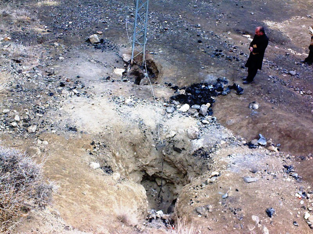
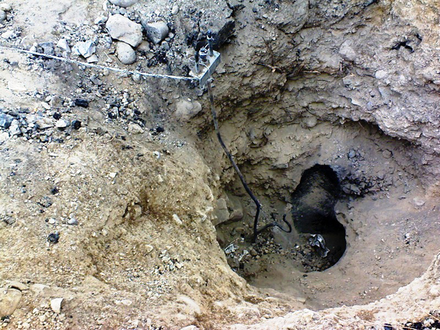
Explosions, ash plumes, ashfall, and lava flows during April-September 2023
The remote volcano of Bagana is located in central Bougainville Island, Papua New Guinea. Recorded eruptions date back to 1842 and activity has consisted of effusive activity that has built a small lava dome in the summit crater and occasional explosions that produced pyroclastic flows. The most recent eruption has been ongoing since February 2000 and has produced occasional explosions, ash plumes, and lava flows. More recently, activity has been characterized by ongoing effusive activity and ash emissions (BGVN 48:04). This report updates activity from April through September 2023 that has consisted of explosions, ash plumes, ashfall, and lava flows, using information from the Darwin Volcanic Ash Advisory Center (VAAC) and satellite data.
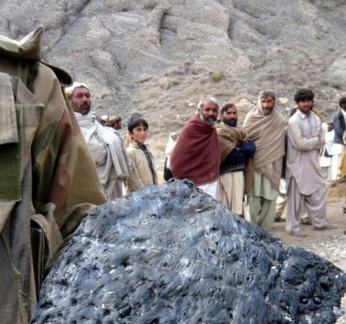
An explosive eruption was reported on 7 July that generated a large gas-and-ash plume to high altitudes and caused significant ashfall in local communities; the eruption plume had reached upper tropospheric (16-18 km altitude) altitudes by 2200, according to satellite images. Sulfur dioxide plumes were detected in satellite images on 8 July and indicated that the plume was likely a mixture of gas, ice, and ash. A report issued by the Autonomous Bougainville Government (ABG) (Torokina District, Education Section) on 10 July noted that significant ash began falling during 2000-2100 on 7 July and covered most areas in the Vuakovi, Gotana (9 km SW), Koromaketo, Laruma (25 km W) and Atsilima (27 km NW) villages. Pyroclastic flows also occurred, according to ground-based reports; small deposits confined to one drainage were inspected by RVO during an overflight on 17 July and were confirmed to be from the 7 July event. Ashfall continued until 10 July and covered vegetation, which destroyed bushes and gardens and contaminated rivers and streams.
RVO reported another eruption on 14 July. The Darwin VAAC stated that an explosive event started around 0830 on 15 July and produced an ash plume that rose to 16.5 km altitude by 1000 and drifted N, according to satellite images. The plume continued to drift N and remained visible through 1900, and by 2150 it had dissipated.
Ashfall likely from both the 7 and 15 July events impacted about 8,111 people in Torokina (20 km SW), including Tsito/Vuakovi, Gotana, Koromaketo, Kenaia, Longkogari, Kenbaki, Piva (13 km SW), and Atsinima, and in the Tsitovi district, according to ABG. Significant ashfall was also reported in Ruruvu (22 km N) in the Wakunai District of Central Bougainville, though the thickness of these deposits could not be confirmed. An evacuation was called for the villages in Wakunai, where heavy ashfall had contaminated water sources; the communities of Ruruvu, Togarau, Kakarapaia, Karauturi, Atao, and Kuritaturi were asked to evacuate to a disaster center at the Wakunai District Station, and communities in Torokina were asked to evacuate to the Piva District station. According to a news article, more than 7,000 people needed temporary accommodations, with about 1,000 people in evacuation shelters. Ashfall had deposited over a broad area, contaminating water supplies, affecting crops, and collapsing some roofs and houses in rural areas. Schools were temporarily shut down. Intermittent ash emissions continued through the end of July and drifted NNW, NW, and SW. Fine ashfall was reported on the coast of Torokina, and ash plumes also drifted toward Laruma and Atsilima.
A small explosive eruption occurred at 2130 on 28 July that ejected material from the crater vents, according to reports from Torokina, in addition to a lava flow that contained two lobes. A second explosion was detected at 2157. Incandescence from the lava flow was visible from Piva as it descended the W flank around 2000 on 29 July (figure 47). The Darwin VAAC reported that a strong thermal anomaly was visible in satellite images during 30-31 July and that ash emissions rose to 2.4 km altitude and drifted WSW on 30 July. A ground report from RVO described localized emissions at 0900 on 31 July.
The Darwin VAAC reported that ash plumes were identified in satellite imagery at 0800 and 1220 on 12 August and rose to 2.1 km and 3 km altitude and drifted NW and W, respectively. A news report stated that aid was sent to more than 6,300 people that were adversely affected by the eruption. Photos taken during 17-19 August showed ash emissions rising no higher than 1 km above the summit and drifting SE. A small explosion generated an ash plume during the morning of 19 August. Deposits from small pyroclastic flows were also captured in the photos. Satellite images captured lava flows and pyroclastic flow deposits. Two temporary seismic stations were installed near Bagana on 17 August at distances of 7 km WSW (Vakovi station) and 11 km SW (Kepox station). The Kepox station immediately started to record continuous, low-frequency background seismicity.
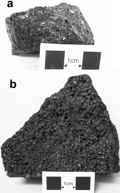
Satellite data. Little to no thermal activity was detected during April through mid-July 2023; only one anomaly was recorded during early April and one during early June, according to MIROVA (Middle InfraRed Observation of Volcanic Activity) data (figure 48). Thermal activity increased in both power and frequency during mid-July through September, although there were still some short gaps in detected activity. MODVOLC also detected increased thermal activity during August; thermal hotspots were detected a total of five times on 19, 20, and 27 August. Weak thermal anomalies were also captured in infrared satellite images on clear weather days throughout the reporting period on 7, 12, and 17 April, 27 May, 1, 6, 16, and 31 July, and 19 September (figure 48); a strong thermal anomaly was visible on 31 July. Distinct sulfur dioxide plumes that drifted generally NW were intermittently captured by the TROPOMI instrument on the Sentinel-5P satellite and sometimes exceeded two Dobson Units (DUs) (figure 49).
Geologic Background. Bagana volcano, in a remote portion of central Bougainville Island, is frequently active. This massive symmetrical cone was largely constructed by an accumulation of viscous andesitic lava flows. The entire edifice could have been constructed in about 300 years at its present rate of lava production. Eruptive activity is characterized by non-explosive effusion of viscous lava that maintains a small lava dome in the summit crater, although occasional explosive activity produces pyroclastic flows. Lava flows with tongue-shaped lobes up to 50 m thick and prominent levees descend the flanks on all sides.
Information Contacts: Rabaul Volcano Observatory (RVO), Geohazards Management Division, Department of Mineral Policy and Geohazards Management (DMPGM), PO Box 3386, Kokopo, East New Britain Province, Papua New Guinea; Darwin Volcanic Ash Advisory Centre (VAAC), Bureau of Meteorology, Northern Territory Regional Office, PO Box 40050, Casuarina, NT 0811, Australia (URL: http://www.bom.gov.au/info/vaac/); MIROVA (Middle InfraRed Observation of Volcanic Activity), a collaborative project between the Universities of Turin and Florence (Italy) supported by the Centre for Volcanic Risk of the Italian Civil Protection Department (URL: http://www.mirovaweb.it/); Hawai'i Institute of Geophysics and Planetology (HIGP) - MODVOLC Thermal Alerts System, School of Ocean and Earth Science and Technology (SOEST), Univ. of Hawai'i, 2525 Correa Road, Honolulu, HI 96822, USA (URL: http://modis.higp.hawaii.edu/); NASA Global Sulfur Dioxide Monitoring Page, Atmospheric Chemistry and Dynamics Laboratory, NASA Goddard Space Flight Center (NASA/GSFC), 8800 Greenbelt Road, Goddard, Maryland, USA (URL: https://so2.gsfc.nasa.gov/); Copernicus Browser, Copernicus Data Space Ecosystem, European Space Agency (URL: https://dataspace.copernicus.eu/browser/); Autonomous Bougainville Government, P.O Box 322, Buka, AROB, PNG (URL: https://abg.gov.pg/); Andrew Tupper (Twitter: @andrewcraigtupp); Simon Carn, Geological and Mining Engineering and Sciences, Michigan Technological University, 1400 Townsend Drive, Houghton, MI 49931, USA (URL: http://www.volcarno.com/, Twitter: @simoncarn); Radio NZ (URL: https://www.rnz.co.nz/news/pacific/494464/more-than-7-000-people-in-bougainville-need-temporary-accommodation-after-eruption); USAID, 1300 Pennsylvania Ave, NW, Washington DC 20004, USA (URL: https://www.usaid.gov/pacific-islands/press-releases/aug-08-2023-united-states-provides-immediate-emergency-assistance-support-communities-affected-mount-bagana-volcanic-eruptions).
Mayon (Philippines) — October 2023 Cite this Report
Mayon
Philippines
13.257°N, 123.685°E; summit elev. 2462 m
All times are local (unless otherwise noted)
Lava flows, pyroclastic flows, ash emissions, and seismicity during April-September 2023
Mayon is located in the Philippines and has steep upper slopes capped by a small summit crater. Historical eruptions date back to 1616 CE that have been characterized by Strombolian eruptions, lava flows, pyroclastic flows, and mudflows. Eruptions mostly originated from a central conduit. Pyroclastic flows and mudflows have commonly descended many of the approximately 40 drainages that surround the volcano. The most recent eruption occurred during June through October 2022 and consisted of lava dome growth and gas-and-steam emissions (BGVN 47:12). A new eruption was reported during late April 2023 and has included lava flows, pyroclastic density currents, ash emissions, and seismicity. This report covers activity during April through September 2023 based on daily bulletins from the Philippine Institute of Volcanology and Seismology (PHIVOLCS).
During April through September 2023, PHIVOLCS reported near-daily rockfall events, frequent volcanic earthquakes, and sulfur dioxide measurements. Gas-and-steam emissions rose 100-900 m above the crater and drifted in different directions. Nighttime crater incandescence was often visible during clear weather and was accompanied by incandescent avalanches of material. Activity notably increased during June when lava flows were reported on the S, SE, and E flanks (figure 52). The MIROVA graph (Middle InfraRed Observation of Volcanic Activity) showed strong thermal activity coincident with these lava flows, which remained active through September (figure 53). According to the MODVOLC thermal algorithm, a total of 110 thermal alerts were detected during the reporting period: 17 during June, 40 during July, 27 during August, and 26 during September. During early June, pyroclastic density currents (PDCs) started to occur more frequently.
Low activity was reported during much of April and May; gas-and-steam emissions rose 100-900 m above the crater and generally drifted in different directions. A total of 52 rockfall events and 18 volcanic earthquakes were detected during April and 147 rockfall events and 13 volcanic events during May. Sulfur dioxide flux measurements ranged between 400-576 tons per day (t/d) during April, the latter of which was measured on 29 April and between 162-343 t/d during May, the latter of which was measured on 13 May.
Activity during June increased, characterized by lava flows, pyroclastic density currents (PDCs), crater incandescence and incandescent rockfall events, gas-and-steam emissions, and continued seismicity. Weather clouds often prevented clear views of the summit, but during clear days, moderate gas-and-steam emissions rose 100-2,500 m above the crater and drifted in multiple directions. A total of 6,237 rockfall events and 288 volcanic earthquakes were detected. The rockfall events often deposited material on the S and SE flanks within 700-1,500 m of the summit crater and ash from the events drifted SW, S, SE, NE, and E. Sulfur dioxide emissions ranged between 149-1,205 t/d, the latter of which was measured on 10 June. Short-term observations from EDM and electronic tiltmeter monitoring indicated that the upper slopes were inflating since February 2023. Longer-term ground deformation parameters based on EDM, precise leveling, continuous GPS, and electronic tilt monitoring indicated that the volcano remained inflated, especially on the NW and SE flanks. At 1000 on 5 June the Volcano Alert Level (VAL) was raised to 2 (on a 0-5 scale). PHIVOLCS noted that although low-level volcanic earthquakes, ground deformation, and volcanic gas emissions indicated unrest, the steep increase in rockfall frequency may indicate increased dome activity.
A total of 151 dome-collapse PDCs occurred during 8-9 and 11-30 June, traveled 500-2,000 m, and deposited material on the S flank within 2 km of the summit crater. During 8-9 June the VAL was raised to 3. At approximately 1947 on 11 June lava flow activity was reported; two lobes traveled within 500 m from the crater and deposited material on the S (Mi-isi), SE (Bonga), and E (Basud) flanks. Weak seismicity accompanied the lava flow and slight inflation on the upper flanks. This lava flow remained active through 30 June, moving down the S and SE flank as far as 2.5 km and 1.8 km, respectively and depositing material up to 3.3 km from the crater. During 15-16 June traces of ashfall from the PDCs were reported in Sitio Buga, Nabonton, City of Ligao and Purok, and San Francisco, Municipality of Guinobatan. During 28-29 June there were two PDCs generated by the collapse of the lava flow front, which generated a light-brown ash plume 1 km high. Satellite monitors detected significant concentrations of sulfur dioxide beginning on 29 June. On 30 June PDCs primarily affected the Basud Gully on the E flank, the largest of which occurred at 1301 and lasted eight minutes, based on the seismic record. Four PDCs generated between 1800 and 2000 that lasted approximately four minutes each traveled 3-4 km on the E flank and generated an ash plume that rose 1 km above the crater and drifted N and NW. Ashfall was recorded in Tabaco City.
Similar strong activity continued during July; slow lava effusion remained active on the S and SE flanks and traveled as far as 2.8 km and 2.8 km, respectively and material was deposited as far as 4 km from the crater. There was a total of 6,983 rockfall events and 189 PDCs that affected the S, SE, and E flanks. The volcano network detected a total of 2,124 volcanic earthquakes. Continuous gas-and-steam emissions rose 200-2,000 m above the crater and drifted in multiple directions. Sulfur dioxide emissions averaged 792-4,113 t/d, the latter of which was measured on 28 July. During 2-4 July three PDCs were generated from the collapse of the lava flow and resulting light brown plumes rose 200-300 m above the crater. Continuous tremor pulses were reported beginning at 1547 on 3 July through 7 July at 1200, at 2300 on 8 July and going through 0300 on 10 July, and at 2300 on 16 July, as recorded by the seismic network. During 6-9 July there were 10 lava flow-collapse-related PDCs that generated light brown plumes 300-500 m above the crater. During 10-11 July light ashfall was reported in some areas of Mabinit, Legazpi City, Budiao and Salvacion, Daraga, and Camalig, Albay. By 18 July the lava flow advanced 600 m on the E flank as well.
During 1733 on 18 July and 0434 on 19 July PHIVOLCS reported 30 “ashing” events, which are degassing events accompanied by audible thunder-like sounds and entrained ash at the crater, which produced short, dark plumes that drifted SW. These events each lasted 20-40 seconds, and plume heights ranged from 150-300 m above the crater, as recorded by seismic, infrasound, visual, and thermal monitors. Three more ashing events occurred during 19-20 July. Short-term observations from electronic tilt and GPS monitoring indicate deflation on the E lower flanks in early July and inflation on the NW middle flanks during the third week of July. Longer-term ground deformation parameters from EDM, precise leveling, continuous GPS, and electronic tilt monitoring indicated that the volcano was still generally inflated relative to baseline levels. A short-lived lava pulse lasted 28 seconds at 1956 on 21 July, which was accompanied by seismic and infrasound signals. By 22 July, the only lava flow that remained active was on the SE flank, and continued to extend 3.4 km, while those on the S and E flanks weakened markedly. One ashing event was detected during 30-31 July, whereas there were 57 detected during 31 July-1 August; according to PHIVOLCS beginning at approximately 1800 on 31 July eruptive activity was dominated by phases of intermittent ashing, as well as increased in the apparent rates of lava effusion from the summit crater. The ashing phases consisted of discrete events recorded as low-frequency volcanic earthquakes (LFVQ) typically 30 seconds in duration, based on seismic and infrasound signals. Gray ash plume rose 100 m above the crater and generally drifted NE. Shortly after these ashing events began, new lava began to effuse rapidly from the crater, feeding the established flowed on the SE, E, and E flanks and generating frequent rockfall events.
Intensified unrest persisted during August. There was a total of 4,141 rockfall events, 2,881 volcanic earthquakes, which included volcanic tremor events, 32 ashing events, and 101 PDCs detected throughout the month. On clear weather days, gas-and-steam emissions rose 300-1,500 m above the crater and drifted in different directions (figure 54). Sulfur dioxide emissions averaged 735-4,756 t/d, the higher value of which was measured on 16 August. During 1-2 August the rate of lava effusion decreased, but continued to feed the flows on the SE, S, and E flanks, maintaining their advances to 3.4 km, 2.8 km, and 1.1 km from the crater, respectively (figure 55). Rockfall and PDCs generated by collapses at the lava flow margins and from the summit dome deposited material within 4 km of the crater. During 3-4 August there were 10 tremor events detected that lasted 1-4 minutes. Short-lived lava pulse lasted 35 seconds and was accompanied by seismic and infrasound signals at 0442 on 6 August. Seven collapses were recorded at the front of the lava flow during 12-14 August.
During September, similar activity of slow lava effusion, PDCs, gas-and-steam emissions, and seismicity continued. There was a total of 4,452 rockfall events, 329 volcanic earthquakes, which included volcanic tremor events, two ashing events, and 85 PDCs recorded throughout the month. On clear weather days, gas-and-steam emissions rose 100-1,500 m above the crater and drifted in multiple directions. Sulfur dioxide emissions averaged 609-2,252 t/d, the higher average of which was measured on 6 September. Slow lava effusion continued advancing on the SE, S, and E flanks, maintaining lengths of 3.4 km, 2.8 km, and 1.1 km, respectively. Rockfall and PDC events generated by collapses along the lava flow margins and at the summit dome deposited material within 4 km of the crater.
Geologic Background. Symmetrical Mayon, which rises above the Albay Gulf NW of Legazpi City, is the most active volcano of the Philippines. The steep upper slopes are capped by a small summit crater. Recorded eruptions since 1616 CE range from Strombolian to basaltic Plinian, with cyclical activity beginning with basaltic eruptions, followed by longer periods of andesitic lava flows. Eruptions occur predominately from the central conduit and have also produced lava flows that travel far down the flanks. Pyroclastic density currents and mudflows have commonly swept down many of the approximately 40 ravines that radiate from the summit and have often damaged populated lowland areas. A violent eruption in 1814 killed more than 1,200 people and devastated several towns.
Information Contacts: Philippine Institute of Volcanology and Seismology (PHIVOLCS), Department of Science and Technology, University of the Philippines Campus, Diliman, Quezon City, Philippines (URL: http://www.phivolcs.dost.gov.ph/); MIROVA (Middle InfraRed Observation of Volcanic Activity), a collaborative project between the Universities of Turin and Florence (Italy) supported by the Centre for Volcanic Risk of the Italian Civil Protection Department (URL: http://www.mirovaweb.it/); Hawai'i Institute of Geophysics and Planetology (HIGP) - MODVOLC Thermal Alerts System, School of Ocean and Earth Science and Technology (SOEST), Univ. of Hawai'i, 2525 Correa Road, Honolulu, HI 96822, USA (URL: http://modis.higp.hawaii.edu/); Copernicus Browser, Copernicus Data Space Ecosystem, European Space Agency (URL: https://dataspace.copernicus.eu/browser/); William Rogers, Legazpi City, Albay Province, Philippines.
Nishinoshima (Japan) — October 2023 Cite this Report
Nishinoshima
Japan
27.247°N, 140.874°E; summit elev. 100 m
All times are local (unless otherwise noted)
Eruption plumes and gas-and-steam plumes during May-August 2023
Nishinoshima, located about 1,000 km S of Tokyo, is a small island in the Ogasawara Arc in Japan. The island is the summit of a massive submarine volcano that has prominent submarine peaks to the S, W, and NE. Eruptions date back to 1973 and the current eruption period began in October 2022. Recent activity has consisted of small ash plumes and fumarolic activity (BGVN 48:07). This report covers activity during May through August 2023, using information from monthly reports of the Japan Meteorological Agency (JMA) monthly reports and satellite data.
Activity during May through June was relatively low. The Japan Coast Guard (JCG) did overflights on 14 and 22 June and reported white gas-and-steam emissions rising 600 m and 1,200 m from the central crater of the pyroclastic cone, respectively (figure 125). In addition, multiple white gas-and-steam emissions rose from the inner rim of the W side of the crater and from the SE flank of the pyroclastic cone. Discolored brown-to-green water was observed around almost the entire perimeter of the island; on 22 June light green discolored water was observed off the S coast of the island.
Observations from the Himawari meteorological satellite confirmed an eruption on 9 and 10 July. An eruption plume rose 1.6 km above the crater and drifted N around 1300 on 9 July. Satellite images acquired at 1420 and 2020 on 9 July and at 0220 on 10 July showed continuing emissions that rose 1.3-1.6 km above the crater and drifted NE and N. The Tokyo VAAC reported that an ash plume seen by a pilot and identified in a satellite image at 0630 on 21 July rose to 3 km altitude and drifted S.
Aerial observations conducted by JCG on 8 August showed a white-and-gray plume rising from the central crater of the pyroclastic cone, and multiple white gas-and-steam emissions were rising from the inner edge of the western crater and along the NW-SE flanks of the island (figure 126). Brown-to-green discolored water was also noted around the perimeter of the island.
Intermittent low-to-moderate power thermal anomalies were recorded in the MIROVA graph (Middle InfraRed Observation of Volcanic Activity), showing an increase in both frequency and power beginning in July (figure 127). This increase in activity coincides with eruptive activity on 9 and 10 July, characterized by eruption plumes. According to the MODVOLC thermal alert algorithm, one thermal hotspot was recorded on 20 July. Weak thermal anomalies were also detected in infrared satellite imagery, accompanied by strong gas-and-steam plumes (figure 128).
Geologic Background. The small island of Nishinoshima was enlarged when several new islands coalesced during an eruption in 1973-74. Multiple eruptions that began in 2013 completely covered the previous exposed surface and continued to enlarge the island. The island is the summit of a massive submarine volcano that has prominent peaks to the S, W, and NE. The summit of the southern cone rises to within 214 m of the ocean surface 9 km SSE.
Information Contacts: Japan Meteorological Agency (JMA), 1-3-4 Otemachi, Chiyoda-ku, Tokyo 100-8122, Japan (URL: http://www.jma.go.jp/jma/indexe.html); Tokyo Volcanic Ash Advisory Center (VAAC), 1-3-4 Otemachi, Chiyoda-ku, Tokyo 100-8122, Japan (URL: http://ds.data.jma.go.jp/svd/vaac/data/); MIROVA (Middle InfraRed Observation of Volcanic Activity), a collaborative project between the Universities of Turin and Florence (Italy) supported by the Centre for Volcanic Risk of the Italian Civil Protection Department (URL: http://www.mirovaweb.it/); Copernicus Browser, Copernicus Data Space Ecosystem, European Space Agency (URL: https://dataspace.copernicus.eu/browser/).
Krakatau (Indonesia) — October 2023 Cite this Report
Krakatau
Indonesia
6.1009°S, 105.4233°E; summit elev. 285 m
All times are local (unless otherwise noted)
White gas-and-steam plumes and occasional ash plumes during May-August 2023
Krakatau is located in the Sunda Strait between Java and Sumatra, Indonesia. Caldera collapse during the catastrophic 1883 eruption destroyed Danan and Perbuwatan cones and left only a remnant of Rakata. The post-collapse cone of Anak Krakatau (Child of Krakatau) was constructed within the 1883 caldera at a point between the former Danan and Perbuwatan cones; it has been the site of frequent eruptions since 1927. The current eruption period began in May 2021 and has recently consisted of Strombolian eruptions and ash plumes (BGVN 48:07). This report describes lower levels of activity consisting of ash and white gas-and-steam plumes during May through August 2023, based on information provided by the Indonesian Center for Volcanology and Geological Hazard Mitigation, referred to as Pusat Vulkanologi dan Mitigasi Bencana Geologi (PVMBG), MAGMA Indonesia, and satellite data.
Activity was relatively low during May and June. Daily white gas-and-steam emissions rose 25-200 m above the crater and drifted in different directions. Five ash plumes were detected at 0519 on 10 May, 1241 on 11 May, 0920 on 12 May, 2320 on 12 May, and at 0710 on 13 May, and rose 1-2.5 km above the crater and drifted SW. A webcam image taken on 12 May showed ejection of incandescent material above the vent. A total of nine ash plumes were detected during 6-11 June: at 1434 and 00220 on 6 and 7 June the ash plumes rose 500 m above the crater and drifted NW, at 1537 on 8 June the ash plume rose 1 km above the crater and drifted SW, at 0746 and at 0846 on 9 June the ash plumes rose 800 m and 3 km above the crater and drifted SW, respectively, at 0423, 1431, and 1750 on 10 June the ash plumes rose 2 km, 1.5 km, and 3.5 km above the crater and drifted NW, respectively, and at 0030 on 11 June an ash plume rose 2 km above the crater and drifted NW. Webcam images taken on 10 and 11 June at 0455 and 0102, respectively, showed incandescent material ejected above the vent. On 19 June an ash plume at 0822 rose 1.5 km above the crater and drifted SE.
Similar low activity of white gas-and-steam emissions and few ash plumes were reported during July and August. Daily white gas-and-steam emissions rose 25-300 m above the crater and drifted in multiple directions. Three ash plumes were reported at 0843, 0851, and 0852 on 20 July that rose 500-2,000 m above the crater and drifted NW.
The MIROVA (Middle InfraRed Observation of Volcanic Activity) graph of MODIS thermal anomaly data showed intermittent low-to-moderate power thermal anomalies during May through August 2023 (figure 140). Although activity was often obscured by weather clouds, a thermal anomaly was visible in an infrared satellite image of the crater on 12 May, accompanied by an eruption plume that drifted SW (figure 141).
Geologic Background. The renowned Krakatau (frequently mis-named as Krakatoa) volcano lies in the Sunda Strait between Java and Sumatra. Collapse of an older edifice, perhaps in 416 or 535 CE, formed a 7-km-wide caldera. Remnants of that volcano are preserved in Verlaten and Lang Islands; subsequently the Rakata, Danan, and Perbuwatan cones were formed, coalescing to create the pre-1883 Krakatau Island. Caldera collapse during the catastrophic 1883 eruption destroyed Danan and Perbuwatan, and left only a remnant of Rakata. This eruption caused more than 36,000 fatalities, most as a result of tsunamis that swept the adjacent coastlines of Sumatra and Java. Pyroclastic surges traveled 40 km across the Sunda Strait and reached the Sumatra coast. After a quiescence of less than a half century, the post-collapse cone of Anak Krakatau (Child of Krakatau) was constructed within the 1883 caldera at a point between the former Danan and Perbuwatan cones. Anak Krakatau has been the site of frequent eruptions since 1927.
Information Contacts: Pusat Vulkanologi dan Mitigasi Bencana Geologi (PVMBG, also known as Indonesian Center for Volcanology and Geological Hazard Mitigation, CVGHM), Jalan Diponegoro 57, Bandung 40122, Indonesia (URL: http://www.vsi.esdm.go.id/); MAGMA Indonesia, Kementerian Energi dan Sumber Daya Mineral (URL: https://magma.esdm.go.id/v1); MIROVA (Middle InfraRed Observation of Volcanic Activity), a collaborative project between the Universities of Turin and Florence (Italy) supported by the Centre for Volcanic Risk of the Italian Civil Protection Department (URL: http://www.mirovaweb.it/); Copernicus Browser, Copernicus Data Space Ecosystem, European Space Agency (URL: https://dataspace.copernicus.eu/browser/).
Villarrica (Chile) — October 2023 Cite this Report
Villarrica
Chile
39.42°S, 71.93°W; summit elev. 2847 m
All times are local (unless otherwise noted)
Strombolian activity, gas-and-ash emissions, and crater incandescence during April-September 2023
Villarrica, in central Chile, consists of a 2-km-wide caldera that formed about 3,500 years ago and is located at the base of the presently active cone at the NW margin of a 6-km-wide caldera. Historical eruptions eruptions date back to 1558 and have been characterized by mild-to-moderate explosive activity with occasional lava effusions. The current eruption period began in December 2014 and has recently consisted of nighttime crater incandescence, ash emissions, and seismicity (BGVN 48:04). This report covers activity during April through September 2023 and describes occasional Strombolian activity, gas-and-ash emissions, and nighttime crater incandescence. Information for this report primarily comes from the Southern Andes Volcano Observatory (Observatorio Volcanológico de Los Andes del Sur, OVDAS), part of Chile's National Service of Geology and Mining (Servicio Nacional de Geología y Minería, SERNAGEOMIN) and satellite data.
Seismicity during April consisted of long period (LP) events and tremor (TRE); a total of 9,413 LP-type events and 759 TR-type events were detected throughout the month. Nighttime crater incandescence persisted and was visible in the degassing column. Sulfur dioxide data was obtained using Differential Absorption Optical Spectroscopy Equipment (DOAS) that showed an average value of 1,450 ± 198 tons per day (t/d) during 1-15 April and 1,129 ± 201 t/d during 16-30 April, with a maximum daily value of 2,784 t/d on 9 April. Gas-and-steam emissions of variable intensities rose above the active crater as high as 1.3 km above the crater on 13 April. Strombolian explosions were not observed and there was a slight decrease in the lava lake level.
There were 14,123 LP-type events and 727 TR-type events detected during May. According to sulfur dioxide measurements taken with DOAS equipment, the active crater emitted an average value of 1,826 ± 482 t/d during 1-15 May and 912 ± 41 t/d during 16-30 May, with a daily maximum value of 5,155 t/d on 13 May. Surveillance cameras showed continuous white gas-and-steam emissions that rose as high as 430 m above the crater on 27 May. Nighttime incandescence illuminated the gas column less than 300 m above the crater rim was and no pyroclastic emissions were reported. A landslide was identified on 13 May on the E flank of the volcano 50 m from the crater rim and extending 300 m away; SERNAGEOMIN noted that this event may have occurred on 12 May. During the morning of 27 and 28 May minor Strombolian explosions characterized by incandescent ejecta were recorded at the crater rim; the last reported Strombolian explosions had occurred at the end of March.
Seismic activity during June consisted of five volcano-tectonic (VT)-type events, 21,606 LP-type events, and 2,085 TR-type events. The average value of sulfur dioxide flux obtained by DOAS equipment was 1,420 ± 217 t/d during 1-15 June and 2,562 ± 804 t/d, with a maximum daily value of 4,810 t/d on 17 June. White gas-and-steam emissions rose less than 480 m above the crater; frequent nighttime crater incandescence was reflected in the degassing plume. On 12 June an emission rose 100 m above the crater and drifted NNW. On 15 June one or several emissions resulted in ashfall to the NE as far as 5.5 km from the crater, based on a Skysat satellite image. Several Strombolian explosions occurred within the crater; activity on 15 June was higher energy and ejected blocks 200-300 m on the NE slope. Surveillance cameras showed white gas-and-steam emissions rising 480 m above the crater on 16 June. On 19 and 24 June low-intensity Strombolian activity was observed, ejecting material as far as 200 m from the center of the crater to the E.
During July, seismicity included 29,319 LP-type events, 3,736 TR-type events, and two VT-type events. DOAS equipment recorded two days of sulfur dioxide emissions of 4,220 t/d and 1,009 t/d on 1 and 13 July, respectively. Constant nighttime incandescence was also recorded and was particularly noticeable when accompanied by eruptive columns on 12 and 16 July. Minor explosive events were detected in the crater. According to Skysat satellite images taken on 12, 13, and 16 July, ashfall deposits were identified 155 m S of the crater. According to POVI, incandescence was visible from two vents on the crater floor around 0336 on 12 July. Gas-and-ash emissions rose as high as 1.2 km above the crater on 13 July and drifted E and NW. A series of gas-and-steam pulses containing some ash deposited material on the upper E flank around 1551 on 13 July. During 16-31 July, average sulfur dioxide emissions of 1,679 ± 406 t/d were recorded, with a maximum daily value of 2,343 t/d on 28 July. Fine ash emissions were also reported on 16, 17, and 23 July.
Seismicity persisted during August, characterized by 27,011 LP-type events, 3,323 TR-type events, and three VT-type events. The average value of sulfur dioxide measurements taken during 1-15 August was 1,642 ± 270 t/d and 2,207 ± 4,549 t/d during 16-31 August, with a maximum daily value of 3,294 t/d on 27 August. Nighttime crater incandescence remained visible in degassing columns. White gas-and-steam emissions rose 480 m above the crater on 6 August. According to a Skysat satellite image from 6 August, ash accumulation was observed proximal to the crater and was mainly distributed toward the E slope. White gas-and-steam emissions rose 320 m above the crater on 26 August. Nighttime incandescence and Strombolian activity that generated ash emissions were reported on 27 August.
Seismicity during September was characterized by five VT-type events, 12,057 LP-type events, and 2,058 TR-type events. Nighttime incandescence persisted. On 2 September an ash emission rose 180 m above the crater and drifted SE at 1643 (figure 125) and a white gas-and-steam plume rose 320 m above the crater. According to the Buenos Aires VAAC, periods of continuous gas-and-ash emissions were visible in webcam images from 1830 on 2 September to 0110 on 3 September. Strombolian activity was observed on 2 September and during the early morning of 3 September, the latter event of which generated an ash emission that rose 60 m above the crater and drifted 100 m from the center of the crater to the NE and SW. Ashfall was reported to the SE and S as far as 750 m from the crater. The lava lake was active during 3-4 September and lava fountaining was visible for the first time since 26 March 2023, according to POVI. Fountains captured in webcam images at 2133 on 3 September and at 0054 on 4 September rose as high as 60 m above the crater rim and ejected material onto the upper W flank. Sulfur dioxide flux of 1,730 t/d and 1,281 t/d was measured on 3 and 4 September, respectively, according to data obtained by DOAS equipment.
Strong Strombolian activity and larger gas-and-ash plumes were reported during 18-20 September. On 18 September activity was also associated with energetic LP-type events and notable sulfur dioxide fluxes (as high as 4,277 t/d). On 19 September Strombolian activity and incandescence were observed. On 20 September at 0914 ash emissions rose 50 m above the crater and drifted SSE, accompanied by Strombolian activity that ejected material less than 100 m SSE, causing fall deposits on that respective flank. SERNAGEOMIN reported that a Planet Scope satellite image taken on 20 September showed the lava lake in the crater, measuring 32 m x 35 m and an area of 0.001 km2. Several ash emissions were recorded at 0841, 0910, 1251, 1306, 1312, 1315, and 1324 on 23 September and rose less than 150 m above the crater. The sulfur dioxide flux value was 698 t/d on 23 September and 1,097 t/d on 24 September. On 24 September the Volcanic Alert Level (VAL) was raised to Orange (the third level on a four-color scale). SENAPRED maintained the Alert Level at Yellow (the middle level on a three-color scale) for the communities of Villarrica, Pucón (16 km N), Curarrehue, and Panguipulli.
During 24-25 September there was an increase in seismic energy (observed at TR-events) and acoustic signals, characterized by 1 VT-type event, 213 LP-type events, and 124 TR-type events. Mainly white gas-and-steam emissions, in addition to occasional fine ash emissions were recorded. During the early morning of 25 September Strombolian explosions were reported and ejected material 250 m in all directions, though dominantly toward the NW. On 25 September the average value of sulfur dioxide flux was 760 t/d. Seismicity during 25-30 September consisted of five VT-type events, 1,937 LP-type events, and 456 TR-type events.
During 25-29 September moderate Strombolian activity was observed and ejected material as far as the crater rim. In addition, ash pulses lasting roughly 50 minutes were observed around 0700 and dispersed ENE. During 26-27 September a TR episode lasted 6.5 hours and was accompanied by discrete acoustic signals. Satellite images from 26 September showed a spatter cone on the crater floor with one vent that measured 10 x 14 m and a smaller vent about 35 m NE of the cone. SERNAGEOMIN reported an abundant number of bomb-sized blocks up to 150 m from the crater, as well as impact marks on the snow, which indicated explosive activity. A low-altitude ash emission was observed drifting NW around 1140 on 28 September, based on webcam images. Between 0620 and 0850 on 29 September an ash emission rose 60 m above the crater and drifted NW. During an overflight taken around 1000 on 29 September scientists observed molten material in the vent, a large accumulation of pyroclasts inside the crater, and energetic degassing, some of which contained a small amount of ash. Block-sized pyroclasts were deposited on the internal walls and near the crater, and a distal ash deposit was also visible. The average sulfur dioxide flux measured on 28 September was 344 t/d. Satellite images taken on 29 September ashfall was deposited roughly 3 km WNW from the crater and nighttime crater incandescence remained visible. The average sulfur dioxide flux value from 29 September was 199 t/d. On 30 September at 0740 a pulsating ash emission rose 1.1 km above the crater and drifted NNW (figure 126). Deposits on the S flank extended as far as 4.5 km from the crater rim, based on satellite images from 30 September.
Infrared MODIS satellite data processed by MIROVA (Middle InfraRed Observation of Volcanic Activity) showed intermittent thermal activity during April through September, with slightly stronger activity detected during late September (figure 127). Small clusters of thermal activity were detected during mid-June, early July, early August, and late September. According to the MODVOLC thermal alert system, a total of four thermal hotspots were detected on 7 July and 3 and 23 September. This activity was also intermittently captured in infrared satellite imagery on clear weather days (figure 128).
Geologic Background. The glacier-covered Villarrica stratovolcano, in the northern Lakes District of central Chile, is ~15 km south of the city of Pucon. A 2-km-wide caldera that formed about 3,500 years ago is located at the base of the presently active, dominantly basaltic to basaltic andesite cone at the NW margin of a 6-km-wide Pleistocene caldera. More than 30 scoria cones and fissure vents are present on the flanks. Plinian eruptions and pyroclastic flows that have extended up to 20 km from the volcano were produced during the Holocene. Lava flows up to 18 km long have issued from summit and flank vents. Eruptions documented since 1558 CE have consisted largely of mild-to-moderate explosive activity with occasional lava effusion. Glaciers cover 40 km2 of the volcano, and lahars have damaged towns on its flanks.
Information Contacts: Servicio Nacional de Geología y Minería (SERNAGEOMIN), Observatorio Volcanológico de Los Andes del Sur (OVDAS), Avda Sta María No. 0104, Santiago, Chile (URL: http://www.sernageomin.cl/); Proyecto Observación Villarrica Internet (POVI) (URL: http://www.povi.cl/); Sistema y Servicio Nacional de Prevención y Repuesta Ante Desastres (SENAPRED), Av. Beauchef 1671, Santiago, Chile (URL: https://web.senapred.cl/); Buenos Aires Volcanic Ash Advisory Center (VAAC), Servicio Meteorológico Nacional-Fuerza Aérea Argentina, 25 de mayo 658, Buenos Aires, Argentina (URL: http://www.smn.gov.ar/vaac/buenosaires/inicio.php); MIROVA (Middle InfraRed Observation of Volcanic Activity), a collaborative project between the Universities of Turin and Florence (Italy) supported by the Centre for Volcanic Risk of the Italian Civil Protection Department (URL: http://www.mirovaweb.it/); Hawai'i Institute of Geophysics and Planetology (HIGP) - MODVOLC Thermal Alerts System, School of Ocean and Earth Science and Technology (SOEST), Univ. of Hawai'i, 2525 Correa Road, Honolulu, HI 96822, USA (URL: http://modis.higp.hawaii.edu/); Copernicus Browser, Copernicus Data Space Ecosystem, European Space Agency (URL: https://dataspace.copernicus.eu/browser/).
Merapi (Indonesia) — October 2023 Cite this Report
Merapi
Indonesia
7.54°S, 110.446°E; summit elev. 2910 m
All times are local (unless otherwise noted)
Frequent incandescent avalanches during April-September 2023
Merapi, located just north of the major city of Yogyakarta in central Java, Indonesia, has had activity within the last 20 years characterized by pyroclastic flows and lahars accompanying growth and collapse of the steep-sided active summit lava dome. The current eruption period began in late December 2020 and has more recently consisted of ash plumes, intermittent incandescent avalanches of material, and pyroclastic flows (BGVN 48:04). This report covers activity during April through September 2023, based on information from Balai Penyelidikan dan Pengembangan Teknologi Kebencanaan Geologi (BPPTKG), the Center for Research and Development of Geological Disaster Technology, a branch of PVMBG which specifically monitors Merapi. Additional information comes from the Pusat Vulkanologi dan Mitigasi Bencana Geologi (PVMBG, also known as Indonesian Center for Volcanology and Geological Hazard Mitigation, CVGHM), MAGMA Indonesia, the Darwin Volcanic Ash Advisory Centre (VAAC), and various satellite data.
Activity during April through September 2023 primarily consisted of incandescent avalanches of material that mainly affected the SW and W flanks and traveled as far as 2.3 km from the summit (table 25) and white gas-and-steam emissions that rose 10-1,000 m above the crater.
Table 25. Monthly summary of avalanches and avalanche distances recorded at Merapi during April through September 2023. The number of reported avalanches does not include instances where possible avalanches were heard but could not be visually confirmed as a result of inclement weather. Data courtesy of BPPTKG (April-September 2023 daily reports).
| Month |
Average number of avalanches per day |
Distance avalanches traveled (m) |
| Apr 2023 |
19 |
1,200-2,000 |
| May 2023 |
22 |
500-2,000 |
| Jun 2023 |
18 |
1,200-2,000 |
| Jul 2023 |
30 |
300-2,000 |
| Aug 2023 |
25 |
400-2,300 |
| Sep 2023 |
23 |
600-2,000 |
BPPTKG reported that during April and May white gas-and-steam emissions rose 10-750 m above the crater, incandescent avalanches descended 500-2,000 m on the SW and W flanks (figure 135). Cloudy weather often prevented clear views of the summit, and sometimes avalanches could not be confirmed. According to a webcam image, a pyroclastic flow was visible on 17 April at 0531. During the week of 28 April and 4 May a pyroclastic flow was reported on the SW flank, traveling up to 2.5 km. According to a drone overflight taken on 17 May the SW lava dome volume was an estimated 2,372,800 cubic meters and the dome in the main crater was an estimated 2,337,300 cubic meters.
During June and July similar activity persisted with white gas-and-steam emissions rising 10-350 m above the crater and frequent incandescent avalanches that traveled 300-2,000 m down the SW, W, and S flanks (figure 136). Based on an analysis of aerial photos taken on 24 June the volume of the SW lava dome was approximately 2.5 million cubic meters. A pyroclastic flow was observed on 5 July that traveled 2.7 km on the SW flank. According to the Darwin VAAC multiple minor ash plumes were identified in satellite images on 19 July that rose to 3.7 km altitude and drifted S and SW. During 22, 25, and 26 July a total of 17 avalanches descended as far as 1.8 km on the S flank.
Frequent white gas-and-steam emissions continued during August and September, rising 10-450 m above the crater. Incandescent avalanches mainly affected the SW and W flanks and traveled 400-2,300 m from the vent (figure 137). An aerial survey conducted on 10 August was analyzed and reported that estimates of the SW dome volume was 2,764,300 cubic meters and the dome in the main crater was 2,369,800 cubic meters.
Frequent and moderate-power thermal activity continued throughout the reporting period, according to a MIROVA (Middle InfraRed Observation of Volcanic Activity) analysis of MODIS satellite data (figure 138). There was an increase in the number of detected anomalies during mid-May. The MODVOLC thermal algorithm recorded a total of 47 thermal hotspots: six during April, nine during May, eight during June, 15 during July, four during August, and five during September. Some of this activity was captured in infrared satellite imagery on clear weather days, sometimes accompanied by incandescent material on the SW flank (figure 139).
Geologic Background. Merapi, one of Indonesia's most active volcanoes, lies in one of the world's most densely populated areas and dominates the landscape immediately north of the major city of Yogyakarta. It is the youngest and southernmost of a volcanic chain extending NNW to Ungaran volcano. Growth of Old Merapi during the Pleistocene ended with major edifice collapse perhaps about 2,000 years ago, leaving a large arcuate scarp cutting the eroded older Batulawang volcano. Subsequent growth of the steep-sided Young Merapi edifice, its upper part unvegetated due to frequent activity, began SW of the earlier collapse scarp. Pyroclastic flows and lahars accompanying growth and collapse of the steep-sided active summit lava dome have devastated cultivated lands on the western-to-southern flanks and caused many fatalities.
Information Contacts: Balai Penyelidikan dan Pengembangan Teknologi Kebencanaan Geologi (BPPTKG), Center for Research and Development of Geological Disaster Technology (URL: http://merapi.bgl.esdm.go.id/, Twitter: @BPPTKG); MAGMA Indonesia, Kementerian Energi dan Sumber Daya Mineral (URL: https://magma.esdm.go.id/v1); Pusat Vulkanologi dan Mitigasi Bencana Geologi (PVMBG, also known as Indonesian Center for Volcanology and Geological Hazard Mitigation, CVGHM), Jalan Diponegoro 57, Bandung 40122, Indonesia (URL: http://www.vsi.esdm.go.id/); Darwin Volcanic Ash Advisory Centre (VAAC), Bureau of Meteorology, Northern Territory Regional Office, PO Box 40050, Casuarina, NT 0811, Australia (URL: http://www.bom.gov.au/info/vaac/); MIROVA (Middle InfraRed Observation of Volcanic Activity), a collaborative project between the Universities of Turin and Florence (Italy) supported by the Centre for Volcanic Risk of the Italian Civil Protection Department (URL: http://www.mirovaweb.it/); Hawai'i Institute of Geophysics and Planetology (HIGP) - MODVOLC Thermal Alerts System, School of Ocean and Earth Science and Technology (SOEST), Univ. of Hawai'i, 2525 Correa Road, Honolulu, HI 96822, USA (URL: http://modis.higp.hawaii.edu/); Copernicus Browser, Copernicus Data Space Ecosystem, European Space Agency (URL: https://dataspace.copernicus.eu/browser/); Øystein Lund Andersen (URL: https://www.oysteinlundandersen.com/, https://twitter.com/oysteinvolcano).
Ebeko
Russia
50.686°N, 156.014°E; summit elev. 1103 m
All times are local (unless otherwise noted)
Moderate explosive activity with ash plumes continued during June-November 2023
Ebeko, located on the N end of Paramushir Island in Russia’s Kuril Islands just S of the Kamchatka Peninsula, consists of three summit craters along a SSW-NNE line at the northern end of a complex of five volcanic cones. Observed eruptions date back to the late 18th century and have been characterized as small-to-moderate explosions from the summit crater, accompanied by intense fumarolic activity. The current eruptive period began in June 2022, consisting of frequent explosions, ash plumes, and thermal activity (BGVN 47:10, 48:06). This report covers similar activity during June-November 2023, based on information from the Kamchatka Volcanic Eruptions Response Team (KVERT) and satellite data.
Moderate explosive activity continued during June-November 2023 (figures 50 and 51). According to visual data from Severo-Kurilsk, explosions sent ash 2-3.5 km above the summit (3-4.5 km altitude) during most days during June through mid-September. Activity after mid-September was slightly weaker, with ash usually reaching less than 2 km above the summit. According to KVERT the volcano in October and November was, with a few exceptions, either quiet or obscured by clouds that prevented satellite observations. KVERT issued Volcano Observatory Notices for Aviation (VONA) on 8 and 12 June, 13 and 22 July, 3 and 21 August, and 31 October warning of potential aviation hazards from ash plumes drifting 3-15 km from the volcano. Based on satellite data, KVERT reported a persistent thermal anomaly whenever weather clouds permitted viewing.
Geologic Background. The flat-topped summit of the central cone of Ebeko volcano, one of the most active in the Kuril Islands, occupies the northern end of Paramushir Island. Three summit craters located along a SSW-NNE line form Ebeko volcano proper, at the northern end of a complex of five volcanic cones. Blocky lava flows extend west from Ebeko and SE from the neighboring Nezametnyi cone. The eastern part of the southern crater contains strong solfataras and a large boiling spring. The central crater is filled by a lake about 20 m deep whose shores are lined with steaming solfataras; the northern crater lies across a narrow, low barrier from the central crater and contains a small, cold crescentic lake. Historical activity, recorded since the late-18th century, has been restricted to small-to-moderate explosive eruptions from the summit craters. Intense fumarolic activity occurs in the summit craters, on the outer flanks of the cone, and in lateral explosion craters.
Information Contacts: Kamchatka Volcanic Eruptions Response Team (KVERT), Far Eastern Branch, Russian Academy of Sciences, 9 Piip Blvd., Petropavlovsk-Kamchatsky, 683006, Russia (URL: http://www.kscnet.ru/ivs/kvert/).
Search Bulletin Archive by Publication Date
Select a month and year from the drop-downs and click "Show Issue" to have that issue displayed in this tab.
The default month and year is the latest issue available.
Bulletin of the Global Volcanism Network - Volume 37, Number 03 (March 2012)
Managing Editor: Richard Wunderman
Akutan (United States)
Steaming, seismically active
False Reports (Unknown)
Pakistan: Peculiar activity emitted less than 5 m3 of frothy basalt
Fournaise, Piton de la (France)
Increased seismicity and eruption during late 2010
Hierro (Spain)
Update on submarine eruption
Kelud (Indonesia)
Amid quiet, a look back at aspects of the 2007 eruption
Long Valley (United States)
2009 summary, deep seismic swarm at Mammoth Mountain
Maderas (Nicaragua)
Destructive 2005 seismicity; youngest deposits dated 70.4 ± 6.1 ka B.P
Puyehue-Cordon Caulle (Chile)
June 2011 eruption emits circum-global ash clouds
Reventador (Ecuador)
Dome growth; lava and pyroclastic flows; lahar takes bridge
Akutan (United States) — March 2012 Cite this Report
Akutan
United States
54.134°N, 165.986°W; summit elev. 1303 m
All times are local (unless otherwise noted)
Steaming, seismically active
We report Akutan non-eruptive seismic activity after our mid-1996 report (BGVN 21:06) through December 2010. AVO (Alaska Volcano Observatory) reporting emphasized seismicity in 2000, 2007, 2008, 2009, and 2010, including seismicity during 2007 triggered by an M 8.2 earthquake in the Kurile islands.
Background. Akutan Island is home to indigenous people located in several coastal villages, and the base of a large fish processing facility. The island resides in the Aleutian arc, a string of islands projecting ~2,000 km into the Bering Sea from the Alaskan Peninsula (figure 2).
Akutan Island (figure 3) has a vegetated coast line dotted with spectacular bridges and caves created by the erosion of numerous lava tubes. Waythomas and others (1998) presented a map showing that much of the coastline is susceptible to rockfall avalanches and points out that these may trigger local tsunamis. The authors also analyzed the likely path of lava flows.
A 2 km diameter caldera atop the 1,303 m high volcano is breached to the NW, and elsewhere encircled by crater walls 60 to 365 m high. The caldera contains a ~200 m high cinder cone, and a small lake. Fumeroles lay along the summit flank toward the E (Miller and others, 1998). The cinder cone has been the site of all historical eruptive activity (Richter and others, 1998; Waythomas and others, 1998).
The village of Akatan ( figure 4), ~ 13 km E of the volcano, hosts the Trident seafood plant, the largest such plant in North America, employing up to 900 seasonal workers (McGimsey, 2011). Akutan villagers and seafood plant employees fled the island during the 1996 seismic events (Li and others, 2000). The cited references provide many details omitted here.
According to Diefenbach and others (2009), Akutan has been the most active of the volcanoes monitored by AVO, having over 20 eruptions since 1790; more than any other Alaskan volcano.
A 2009 report by AVO noted that 11 eruptions occurred at Akutan during 1980-1992, many lasting several months (table 5). The most recent eruption started in December 2009 but the eruption's end was not clearly constrained (table 5). A seismic swarm took place in 1996, an episode without a corresponding eruption.
Table 5. Akutan eruptions tabulated from January 1980 to 2009. Courtesy of Diefenbach and others (2009).
| Start Date |
End Date |
VEI |
| 08 Jul 1980 |
08 Jul 1980 |
2 |
| 07 Oct 1982 |
May 1983 |
2 |
| 03 Feb 1986 |
14 Jun 1986 |
2 |
| 31 Jan 1987 |
24 Jun 1987 |
2 |
| 26 Mar 1988 |
20 Jul 1988 |
2 |
| 27 Feb 1989 |
31 Mar 1989 |
2 |
| 22 Jan 1990 |
22 Jan 1990 |
2 |
| 06 Sep 1990 |
01 Oct 1990 |
2 |
| 15 Sep 1991 |
28 Nov 1991 |
2 |
| 08 Mar 1992 |
31 May 1992 |
2 |
| 18 Dec 1992 |
-- |
1 |
From 1980 to 2009, Alaskan eruptions made up to 77% of the total reported in the United States (Diefenbach and others, 2009). Note that, even though during 1980-2009 Akutan erupted more times than other US volcanoes, this distinction is only one of many that can be used for comparisons. For example, in the course of that interval and the 11 recorded eruptions at Akutan, it clearly emitted less material and the eruptive intervals spanned much less time than eruptions at either Kīlauea or Mt. St. Helens.
1996 seismicity. In March 1996, two strong earthquake swarms struck the island, causing minor damage and prompting some residents and dozens of plant employees to leave the island. The seismicity, reported in BGVN 21:06, was probably the result of a magmatic intrusion (Lu and others, 2000). They stated the following:
"In March 1996 an intense swarm of volcano-tectonic earthquakes (~3,000 felt by local residents, M max = 5.1, cumulative moment of 2.7 × 10¹⁸ N m) beneath Akutan Island in the Aleutian volcanic arc, Alaska, produced extensive ground cracks but no eruption of Akutan volcano. Synthetic aperture radar interferograms that span the time of the swarm reveal complex island-wide deformation: the western part of the island including Akutan volcano moved upward, while the eastern part moved downward. The axis of the deformation approximately aligns with new ground cracks on the western part of the island and with Holocene normal faults that were reactivated during the swarm on the eastern part of the island. The axis is also roughly parallel to the direction of greatest compressional stress in the region. No ground movements greater than 2.83 cm were observed outside the volcano's summit caldera for periods of 4 years before or 2 years after the swarm. We modeled the deformation primarily as the emplacement of a shallow, E-W trending, north dipping dike plus inflation of a deep, Mogi-type [spherical] magma body beneath the volcano. The pattern of subsidence on the eastern part of the island is poorly constrained. It might have been produced by extensional tectonic strain that both reactivated preexisting faults on the eastern part of the island and facilitated magma movement beneath the western part. Alternatively, magma intrusion beneath the volcano might have been the cause of extension and subsidence in the eastern part of the island."
The 11 March 1996 swarm involved more than 80 earthquakes of M 3.0 or greater with the largest measuring M 5.2. The 13 March swarm involved more than 120 events of M 3.0 or greater with the largest measuring M 5.3 (Waythomas and others, 1998).
As a result, new ground cracks developed ( figure 5) and Waythomas and others (1998) described them as follows: "Numerous fresh, linear ground cracks were discovered in three areas on Akutan Island during field studies in the summer of 1996. Ground breaks and cracks likely formed during the strong seismic swarms in March. The ground cracks extend discontinuously from the NE side of the island near Lava Point to the island's SE side [figure 5].
"The most extensive ground cracks are between Lava Point and the volcano summit [ figure 6]. In this area, the cracks are confined to a zone 300 to 500 m wide and 3 km long. Vertical displacement of the ground surface along individual cracks is 30 to 80 cm. The ground cracks probably formed as magma moved toward the surface between the two most recently active vents on the volcano. Ground cracks on the SE side of the island occur on known faults, indicating that they probably formed in response to motion along these preexisting structures. No ground cracks were found at the head of Akutan Harbor even though this was an area where numerous earthquakes occurred from March through July, 1996."
A permanent seismic network was installed during the summer of 1996 which currently consists of seven short-period stations and five broadband stations (figure 5).
Akutan seismicity, 2000 to 2010. According to AVO annual reports covering the interval 1997-2011, noteworthy seismicity occurred during the years 2000, 2007, 2008, 2009, and 2010.
On 19 January 2000, five earthquakes occurred in less than 30 minutes with epicenters 10-11 km E of the summit at hypocentral depths of ~5-6 km. This was the same region as the March 1996 volcanic swarm.
Akutan was one of several Alaska volcanoes with behavioral anomalies triggered by the M 8.2 earthquake generated in the Kurile Islands on 12 January 2007 at 0423 UTC (McGimsey, 2011). Seismologists located four of the seven largest triggered M 0.0-0.5 earthquakes at Akutan and found their depths in the range from +0.86 to -2.17 km (figure 7). The locations fell along the trend of intense seismicity and ground breakage that occurred in March 1996 at Akutan (Neal and others, 1997; Waythomas and others, 1998; Lu and others, 2005). The AVO Akutan seismic network recorded the triggered seismicity.
In early October 2007, AVO remote sensors detected signs of renewed inflation of the W flank during the previous month using GPS time series. This inflation was in the same area that inflated during the 1996 seismic crisis. A few days later, on 8 October 2007, the manager of the Trident seafood processing plant called to alert AVO of strong steaming near Hot Springs Bay (figure 8) at a spot significantly up slope from established hot springs in the valley. This plume location was considered "new" by local observers. The established lower-valley thermal springs rarely emit a concentrated, vertically rising steam plume and most earlier reports of steaming arose from the prominent fumarole field located at the 460 m elevation of the E flank at the headwaters of Hot Springs Bay valley. This is also the area of maximum deflation following the 1996 seismic swarms. No unusual seismic activity was noted for the period of W-flank inflation or the location of this steaming episode (McGimsey and others, 2011).
In 2008, over 100 seismic events were recorded. During the next two years, Akutan seismic events decreased to about half that number. During 2010 low frequency earthquakes doubled compared to 2009 (Table 6).
Table 6. Akutan seismic activity for 2008-2010 compiled from AVO/USGS annual reports. Total earthquakes (in the second column) summed those in the Volcano-tectonic and Low frequency columns. '--' indicates data not reported. Courtesy of AVO.
| Year |
Total earthquakes |
Volcano-tectonic |
Low-frequency |
| 2008 |
105 |
-- |
-- |
| 2009 |
45 |
41 |
4 |
| 2010 |
42 |
34 |
8 |
According to AVO, Akutan seismic events during the years 2009 and 2010 were temporally spread roughly throughout the months except for a tight cluster of M 2 earthquakes reported at depths of between ~5 km to ~10 km during the first weeks of January 2010. The majority of earthquakes in 2010 were located within ~5 km of the crater along a N-trending line spanning 10 km. In 2009 the spread was longer, over 20 km.
References. Diefenbach, A.K., Guffanti, M., and Ewert, J.W., 2009, Chronology and references of volcanic eruptions and selected unrest in the United States, 1980-2008: U.S. Geological Survey Open-File Report 2009-1118, 85 p. [http://pubs.usgs.gov/of/2009/1118/].
Dixon, J.P., Stihler, S.D., Power, J.A., and Searcy, C.K., 2010, Catalog of Earthquake Hypocenters at Alaskan Volcanoes: January 1 through December 31, 2009: U.S. Geological Survey Data Series 531.
Dixon, J.P., Stihler, S.D., Power, J.A., and Searcy, C.K., 2011, Catalog of earthquake hypocenters at Alaskan Volcanoes: January 1 through December 31, 2010: U.S. Geological Survey Data Series 645.
Kent, T., 2011, Hydrothermal Alteration of Open Fractures in Prospective Geothermal Drill Cores, Akutan Island, Alaska, Fall Meeting of the American Geophysical Union, 2011, Abstract ##V13D-2637.
Lu, Z., Wicks Jr., C., Power, J.A., and Dzurisin, D., 2000, Ground deformation associated with the March 1996 earthquake swarm at Akutan volcano, Alaska, revealed by satellite radar interferometry, J. Geophys. Res., 105(B9), 21,483-21,495 (DOI:10.1029/2000JB900200).
Miller, T.P., McGimsey, R.G., Richter, D.H., Riehle, J.R., Nye, C.J., Yount, M.E., and Dumoulin, J.A., 1998, Catalog of the historically active volcanoes of Alaska: U.S. Geological Survey Open-File Report 98-582, 104 p. (Also available at http://www.avo.alaska.edu/downloads/catalog.php.)
McGimsey, R.G., Neal, C.A., Dixon, J.P., Malik, Nataliya, and Chibisova, M., 2011, 2007 Volcanic activity in Alaska, Kamchatka, and the Kurile Islands: Summary of events and response of the Alaska Volcano Observatory: U.S. Geological Survey Scientific Investigations Report 2010-5242, 110 p.
Neal, C.A. and McGimsey, R.G., 1997, 1996 Volcanic Activity In Alaska And Kamchatka: Summary Of Events And Response Of The Alaska Volcano Observatory: U.S. Geological Survey Open-File Report 97-433.
Richter, D.H., Waythomas, C.F., McGimsey, R.G., and Stelling, P.L., 1998, Geologic map of Akutan Island, Alaska: U.S. Geological Survey Open-File Report 98-135, 22 p., 1 plate.
Waythomas, C.F., Power, J.A., Richter, D.H., and McGimsey, R.G., 1998, Preliminary volcano-hazard assessment for Akutan Volcano east-central Aleutian Islands, Alaska: U.S. Geological Survey Open-File Report 98-0360, 36 p., 1 plate.
Geologic Background. Akutan contains a 2-km-wide caldera with a large cinder cone in the NE part of the caldera that has been the source of frequent explosive eruptions and occasional lava effusion that covers the caldera floor. An older, largely buried caldera was formed during the late Pleistocene or early Holocene. Two volcanic centers are located on the NW flank. Lava Peak is of Pleistocene age, and a cinder cone lower on the flank produced a lava flow in 1852 that extended the shoreline of the island and forms Lava Point. The 60-365 m deep younger caldera was formed during a major explosive eruption about 1,600 years ago and contains at least three lakes. A lava flow in 1978 traveled through a narrow breach in the north caldera rim almost to the coast. Fumaroles occur at the base of the caldera cinder cone, and hot springs are located NE of the caldera at the head of Hot Springs Bay valley and along the shores of Hot Springs Bay.
Information Contacts: Alaska Volcano Observatory (AVO), a cooperative program of a) U.S. Geological Survey, 4200 University Drive, Anchorage, AK 99508-4667, USA, b) Geophysical Institute, University of Alaska, PO Box 757320, Fairbanks, AK 99775-7320, USA, and c) Alaska Division of Geological & Geophysical Surveys.
False Reports (Unknown) — March 2012 Cite this Report
False Reports
Unknown
Unknown, Unknown; summit elev. m
All times are local (unless otherwise noted)
Pakistan: Peculiar activity emitted less than 5 m3 of frothy basalt
According to a report by Rana and Akhtar (2010) of the Geological Survey of Pakistan (GSP), an M 3.9 earthquake with a focal depth of 60 km occurred on 27 January 2010. It was accompanied by "spewing of molten material, burning of rock fragments, emission of steam, sparks and fumes in Sari (Charri) near Wam (Waam) in Ziarat Valley . . .. The molten material expelled from a small scoria cone and four smaller fissures in Tor Zawar mountain." The village of Wam was devastated on 29 October 2008 when a severe earthquake (M 6.2, focal depth 10 km) hit the city of Ziarat (~28 km ESE from Wam). [Note - Throughout this report we have tried to use the spelling of geographic and geologic features as found in the GSP report, with alternative spellings found in other referenced reports placed in parentheses.]
The frothy basalt emitted at Tor Zawar occurred at a spot located hundreds of kilometers from the nearest known Holocene volcanism. The news and various discussions of the site incorrectly attributed the eruption to activity at a mud volcano, a process common in the region. This may be the smallest volume eruption ever documented at a new locality.
Figure 1 shows a geological sketch map of the area of Balochistan Province, Pakistan, where the eruption occurred. The news of volcanic activity was surprising because volcanism has seemingly been absent here for at least the last 10,000 years. The closest identified Holocene volcanoes occur ~400 km N in Afghanistan (Vakak Group and Dacht-Navar Group) and ~800 km W in Iran (Taftan, Bazman, and unnamed volcanoes; figure 2).
News reports from several sources (e.g., The Nation, 3 February 2010; Balochistan Times, 23 February 2010 and 7 March 2010; Ary News, 2 February 2010) noted that residents in nearby areas observed flames at the mountain top for several nights and, on 1 February 2010, the volcano began erupting lava. Explosions followed by smoke emissions were observed. District Coordinator Officer Siddiq Mandokhel confirmed that lava spewed from the volcano. The newspaper Pak Tribune reported on 3 February 2010 that Mandokhel said "he had personally surveyed the site of occurrence, and said that emittance of chemical gases had begun last night, after which it spewed out a molten lava, the size of a meter".
At least two small groups of earth scientists visited the site within 3 to 5 days after the reported 'eruption' event. The field observations by scientists from the GSP were reported in a GSP Information Release (Rana and Akhtar, 2010). Khadim Durrani (2010) issued on his web site an illustrated interview conducted with Din Mohammed Kakar. The two reports mentioned above contain occasional discrepancies within and between the reports, and both include unlabeled figures. During the periods of field observations, no fresh extrusion of volcanic material or sparks was observed. However, heat was still being emitted.
Table 1 contains a brief summary of possible causes and/or production-mechanisms for the molten material that have been suggested by various sources. Additional details are found in sections below.
Table 1. Various explanations for a molten material source and proposed mechanism of erupted surface deposit at Tor Zawar. See original papers for more details.
| Proposed source or mechanism |
Comments |
| Melting of existing Bibai volcanics caused by resistive heating due to local power line, lightning, or some combination of surface sources. |
Mentioned but dismissed by Rana and Akhtar (2010); 'unsupported' according to Kerr and others (2010; Kakar, in Durrani (2010). |
| Frictionally derived melting along thrust fault. |
Rana and Akhtar (2010). |
| Methane gas leakage and flaring with local heating/melting of existing Bibai volcanics. |
Bilham (personal communication). |
| Rupture on Gogai Wam fault during 2008 earthquake created chambers from which molten materials rose and eventually erupted through channels in the weak zone. |
Rana and Akhtar (2010). |
| Melting from heating of lithosphere either by conduction from below or by advection from an intruding magma. |
"It is more likely that a small amount of asthenospheric-derived melt has invaded the lower lithosphere," concluded Kerr and others (2010). |
| 60-80 km deep magma ascended to the surface along Bibai and Gogai thrust faults. |
"Eruption represents a geological event of deep origin," according to Kerr and others (2010). |
Field observations by GSP. Two GSP geoscientists, Asif Nazeer Rana and Sardar Saeed Akhtar, visited the site of the molten material (figure 3) on 2 February 2010 and summarized their observations in a GSP report (Rana and Akhtar, 2010). The following information came from that report. Note that most of the figures reproduced below from the GSP report lacked captions.
The investigators were told on 2 February 2010 by locals that emission of black, molten material started along with tremors on the night of 27 January 2010. The locals observed that steam was continuously emitted from six fissures, and rock fragments were too hot to handle with bare hands. The erupted molten material (looking like lava, scoria and volcanic glass) was found to be cold and solidified on the surface (figures 4 and 5), but was still hot in the subsurface. Heat was still rising from the site during the 3 days of observation.
The molten material flow solidified in concentric layers on reaching the surface (figure 4). The flow structure was ~15 m2 in area and 15 to 60 cm thick. By 2 February, most of the material had been removed as souvenirs by the locals. Rana and Akhtar (2010) reported that the dimension of the lava structure was "1.9 m x 8.2 m in length and 15 cm to 0.6 m thick." The material remaining on the surface after pilferage "was 2.9 m long and 1.5 m wide," covering a area of ~4.3 m2. The ejecta cone was formed from the molten material; the vent pipe of the cone was 0.9 m deep below the surface, but upon excavation it was observed that the cone widened and became inclined below the surface (figure 6).
The ejected molten material and ejecta cone were excavated. A ditch was dug along the fissures to find the opening of the vent. The solidified sheet of this molten material was removed from the surface after documentation, measurement, and photography. Samples of various volcanic materials, including volcanic glass, scoria, pumice, and lava, were collected for lab analyses and petrographic studies. The newly erupted material at the surface was removed, and the complete structure of the ejecta cone was preserved and packed for display in the GSP Museum of Earth Sciences (figure 7). Deeper areas were excavated, a pipe-shaped feature was discovered at a depth of 1 m, leading down to a cone-shaped vent.
The cone-shaped vent was fused shut by the solidification of the material in the orifice. Under the ejecta cone, a pipe of 1 m length and 5 cm diameter led vertically down to a funnel-shaped structure (i.e., wider at the top). The ejecta cone was found to be hollow on breaking the pipe and edifice; the structure looked like an oven, with a shiny, black, fine coating on the walls all around. The cone was underlain by two chambers oriented in the NW-SE direction; dimensions of these chambers were not disclosed.
The temperature of the chamber walls was still burning hot, and when dry bushes were put on the mouth of these chambers, they caught fire. The team did not carry a device for measuring soil temperature and steam from the chambers. The smaller, deeper chamber, ~4.75 m from the main chamber, led SE towards an electric power line pole. The temperature of the smaller chamber was seemingly higher than that of the main chamber. The walls of the chambers were still too hot to touch even 10 days after the lava eruption.
Two rock samples, one described as glassy and one as spongy, collected from the Tor Zawar formerly molten material were analyzed chemically at the GSP Geoscience Advance Research Laboratories for major and trace elements chemistry. Analysis revealed sample compositions of silica (SiO2) of 48.02 and 48.27 wt % and total Na2O+K2O of 5.18 and 5.23 wt. %. The two samples were classified as alkaline basalt (based on classification of Cox, Bell, and Pankhurst, 1979).
The depth of the 27 January 2010 M 3.9 earthquake was reported by the Pakistan Meteorological Department to be 60 km. The investigators found this depth to be quite unusual, as a majority of the tremors in this region have had their origin at shallow depths, generally 10-12 km. It was inferred from the previous seismotectonic investigations of 29 October 2009 earthquake (Rana, Sardar, and Qadir, 2008) that earthquake intensities and the alignment and location of most of their epicenters in this area indicated that a blind fault might be running between Gogai and Wam, passing in close proximity to this erution. There is a strong possibility that the present eruption might have occurred close to the fault plane. This blind fault, the Gogai-Wam fault, is suspected to run for nearly 40 km NW-SE, but no trace of any surface rupture was recorded either in the previous study or in the present study.
Visit and assessment by Din Mohammad Kakar. Khadim Durrani interviewed Din Muhammad Kakar, a sedimentary geologist from the University of Balochistan, about his visit and impressions of the site (Durrani, 2010). Kakar noted that a new, small volcano began spewing lava on 29 January 2010 in Pakistan (rather than the 27 January start date reported in the GSP report above). He visited the site on "day 5 after the start of the volcanic activity" (from this, one might infer that his observations were made on 3 February). Kakar observed little molten material other than two "volcanic vents," 2-3 m apart, and the 2-m-deep pit that was dug out by the GSP (figures 8 and 9). He discovered that the GSP and the Frontier Corps (figure 10) had earlier removed parts of the newly erupted cone and the remaining debris. Kakar noted that the heat of the presumed volcanic activity could still be felt in the openings.
According to an Email note from Kakar to Bulletin editors, the chemistry indicates the same alkali basaltic lava as is found in the Bibai volcanics. Kakar noted that the eruption took place within the Late Cretaceous Bibai formation volcanics (see figure 1) (Kahn, 1998). Other exposed rocks in the area include the Parh group (Cretaceous), Dungan formation (Paleocene), and the Ghazij formation (Eocene). In the Kach-Ziarat area, the Bibai formation is sandwiched between Dungan limestone (above) and the Parh formation (below).
Eye witnesses said that there were flames coming out from the vent, possibly the result of ignited natural gas. In discussion with Bulletin editors, Roger Bilham of the University of Colorado offered the possible explanation that the eruption may have represented the remelting of pre-existing rocks of Bibai Volcanics due to ignition and combustion of natural gas.
Kakar said that the regional tectonics and the volcano's origin were not clear. However, the volcano was not a mud volcano, common in Pakistan. There is the possibility of a partial melting at shallow depth due to recent earthquake activities. He recalled the area had been hit by thousands of aftershocks since October 2008. He noted that his research had found a rupture in the basement rock below the 15-km sedimentary cover, and suggested that reactivation of the Bibai thrust might have been responsible for the recent volcanic activity. According to Kakar, the area is sparsely populated and the eruption caused no damage except for cables and poles associated with a tube well used for agricultural purposes.
Petrographic analyses.Two rock samples were sent by the GSP to Cardiff University and analyzed by Kerr and others (2010). The samples showed two petrographically distinct basalt types (figure 11). One type (sample P2) consisted of completely fresh, light brown glass with a few (
According to Kerr and others (2010), these two rock types "also have slightly different geochemical signatures that can be partially explained by crustal assimilation. Re-melting of local basaltic rocks by short circuiting of a ruptured high-tension electrical cable is considered unlikely. Mantle melt modeling suggests that the lavas have been largely derived from a source in the garnet-spinel transition zone, i.e. well within the lithosphere [i.e., melt from a depth of 60-80 km]. It is proposed that localized asthenospheric melting resulted in relatively depleted melts which were substantially contaminated by [a] fusible lithospheric mantle en route to the surface. Further small-scale eruptions cannot be ruled out."
Recent geophysical research. In the last week of March 2010, the GSP conducted a geophysical survey in the region of the Tor Zawar vent site (Saeed, Rehman, and Abbas, 2011). According to the report, "The syntheses of the magnetic, resistivity soundings and profiling and ground penetration radar (GPR) survey indicate the presence of highly magnetic dual lobe sources, resistive and prominent reflectors from the radar soundings in and around the vent site. The resistivity pseudo sections delineate the lateral and vertical molten flows which have apparently solidified at shallow depth."
The report concluded that "the radar imaging explicitly shows folding of the overlying fine grained clastics", and that they also saw "fracturing in the compact, hard and brittle rock units of compact gravels/limestone and volcanics due to the pressure exerted by the intrusion."
The presence of older volcanic rocks in the area made it difficult to separate older volcanic rocks and structures from the present eruption activity. The geophysical survey was unable to resolve the source or sources of the molten material that erupted as basalt.
References. Cox, K.G., Bell, J.D., and Pankhurst, R.J., 1979, The interpretation of igneous rocks, George Allen and Unwin, Boston, 450 pp.
Durrani, K., 2010, Ziarat's volcanic coughing - an interview with Din Mohammed Kakar, published by admin, March 2, 2010 in Environment, Geology of Pakistan and Natural Disasters, URL: www.khadimsquetta.com/?p=640. (Note that many of the photos in this website item are not described or labeled.)
Geological Survey of Pakistan (GSP), 2011, GSP Year Book 2010-2011, on GSP web site: http://www.gsp.gov.pk.
Kakar, D.M., Szeliga, W., and Bilham, R., 2010, Seismic Potential of the Pishin/Mach Shear Zone in Northern Baluchistan, Pakistan, Seismological Research Letters, v. 81, no. 2, pp. 324.
Khan, A.T., 1998, Sedimentology and petrology of the volcaniclastic rocks of the Bibai Formation, Ziarat District, Balochistan, Pakiston, Thesis, University of Balochistan, Quetta, 179p.
Khan, A.T., Kassi, M.T. and Khan, A.S., 2000, The Upper Cretaceous Bibai submarine Fan (Bibai Formation), Kach Ziatrat Valley, western Suleiman Thrust-Fold Belt, Pakistan, Acta Mineralogica Pakistanica, v. 11, pp. 1-24.
Kerr, A.C., Khan, M., and McDonald, I., 2010, Eruption of basaltic magma at Tor Zawar, Balochistan, Pakistan on 27 January 2010: geochemical and petrological constraints on petrogenesis, Mineralogical Magazine, v. 74, no. 6, pp. 1027-1036.
MonaLisa, and Jan, M.Q., 2010 (10 January), Geoseismological study of the Ziarat (Balochistan) earthquake (doublet?) Of 28 October 2008, Current Science, v. 98, no. 1, p. 50-57.
Rana, A.N., Sardar, S.A., and Qadir, G.T., 2008, Seismotectonic investigations of October 29, 2008 earthquake of Gogai Ziarat, Balochistan, Information Release No. 874, Geological Survey of Pakistan, Islamabad.
Rana, A.N., and Akhtar, S.S., 2010, Preliminary Report on Eruption of Molten Material in Tor Zawar Mountain, Sari, Ziarat, Balochistan on January 27, 2010, Information Release No. 891, Geological Survey of Pakistan, Islamabad, 24 pp. (Summarized in GSP News. V. 17, no. 1-12, p. 12.) (Note that many of the photos in this website item are not described or labeled.)
Saeed, M., Rehman, M., and Abbas, S.A., 2011, Integrated geophysical modeling of volcanic eruption at Tor Zawar, Ziarat, Balochistan, Information Release No. 920, Geological Survey of Pakistan, Islamabad, 79 pp.
Siebert, L., Simkin, T., and Kimberly, P., 2010, Volcanoes of the World, Third Edition, Smithsonion Institution, Washington, D.C., and University of California Press, Berkeley, CA, 551 pp.
Geologic Background. False or otherwise incorrect reports of volcanic activity.
Information Contacts: Imran Khan, Director General, Geological Survey of Pakistan, Sariab Road, Quetta, Pakistan (URL: http://www.gsp.gov.pk); Din Mohammed Kakar, Geology Department, University of Balochistan, Quetta, Pakistan (URL: http://www.uob.edu.pk/); Andrew C. Kerr, Cardiff University, School of Earth and Ocean Sciences, Cardill, Wales, UK (URL: http://www.Cardiff.ac.uk/earth/contactsandpeople/profiles/kerr-andrew.html); Khadim Durrani; Roger Bilham, University of Colorado.
Piton de la Fournaise (France) — March 2012 Cite this Report
Piton de la Fournaise
France
21.244°S, 55.708°E; summit elev. 2632 m
All times are local (unless otherwise noted)
Increased seismicity and eruption during late 2010
Our last Bulletin report (BGVN 35:03) covered eruptive activity through the last eruptive episode, which ended 12 January 2010.
Beginning 14 August and through 10 September 2010, the Observatoire Volcanologique du Piton de la Fournaise (OVPDLF) recorded a slow but steady increase in the number and magnitude of earthquakes from Piton de la Fournaise. Inflation of the summit area began in late August. The following report is based on data received from OVPDLF. It discusses eruptions and related behavior as late as 10 December 2010.
On 13 September 2010, localized deformation W of the Dolomieu crater and a small number of landslides in the crater was observed. On 20 September instruments recorded a significant increase in the number of earthquakes located at the W and S of the Dolomieu crater, although their average magnitude was low.
On 24 September, OVPDLF reported the possibility of an impending eruption. During the night, a seismic crisis began with a series of several tens of earthquakes localized under the Dolomieu crater, which was associated with inflation (approximately 3 cm), especially close to the summit. The most significant deformations were measured on the rim and the N and S sides of the volcano, indicating a shallow magma body was distributed directly below the Dolomieu crater. After decreasing on 27 September, seismicity rose again by 29 September. Earthquakes were located at the base of the volcano, and inflation was noted particularly in the E. A significant number of landslides were detected in the crater. The Alert level remained at 1 ("probable or imminent eruption").
Beginning 7 October 2010, there was a steady increase in the number and magnitude of volcano-tectonic (VT) earthquakes. During 10-11 October the summit area inflated 3-7 cm, and an increase in the number of landslides in the crater was detected. The Alert level remained at 1.
Increased seismicity was again recorded on 14 October 2010, with a new seismic crisis of more than several hundred earthquakes. During this phase, significant ground deformation occurred near the summit, which generated numerous rockfalls inside the Dolomieu crater. At 1411, the seismicity moved toward the SE part of the volcano (Château Fort), and at 1910 an eruption began within the Enclos Fouqué, about 1.5 km SE of the Dolomieu crater rim. Lava fountaining occurred from four vents along a fissure. The Alert level was raised to 2 ("eruption in progress in the Fouqué caldera").
Eruptive activity continued on 15-16 October 2010, developing along a fissure. This eruption included low lava fountains and fed a lava flow moving to the ESE. Lava issued from an area close to the old Château Fort crater at the base of the SE flank of Dolomieu crater and remained within the Enclos Fouqué. Four small cones were active along the eruptive fissure; lava fountaining occured from three of them. A lava flow moved slowly about 1.6 km to the E and SE and approached the break in slope at the Grandes pentes. OVPDLF measured lava temperatures of ~1,100°C.
On 17 October 2010 explosions and degassing accompanied lava emissions. These explosions and degassing decreased on 18 October. The volcanic tremor also decreased to one-seventh compared to the beginning of the eruption. The number of VT events remained low (7/day); the strongest event occurred at 2323, a M 1.4 earthquake localized at about 1,600 m depth under the Bory summit crater. The base and the summit of the volcano remained in inflation. Preliminary estimation of the lava volume erupted was 600,000 m3.
During 19-21 October consistent eruptive activity continued, with weak emissions and small lava fountains at the main eruptive vents located along the eruptive fissure. Explosive activity and degassing decreased, and tremor remained stable. Lava flows extended ESE to ~2 km. Gas emissions decreased, but concentrated to the S and W of the fissure.
On 22 October 2010 eruptions continued, located close to the Château Fort area, in the southern portion of the Enclos Fouqué. During 22-26 October lava fountains and gas emissions originated from one vent, and lava traveled ESE. Gas emissions decreased significantly. At this point, only one cone was active and only a few lava fountains were observed. Volcanic tremor was stable. No earthquakes had been reported since the previous day. GPS ground deformation showed a weak deflation under the volcano.
A sudden increase in activity and tremor began on 27 October 2010 and continued on 28 October. On 29 October, observation made during a flight disclosed that a part of summit cone 3 (the only active cone) had collapsed. Some lava ejecta and gas emissions occurred from this cone, which also contained a small active lava pond. Lava from this cone fed a small, slow moving lava flow. This new lava field remained upstream of the cone named Gros Benard. On 31 October, OVPDLF reported that the eruption had ended.
On 9 December 2010, following a seismic crisis and inflation, a new eruption began from an eruptive fissure oriented N-S, just above the Mi-Côte peak, at ~2,500 m elevation, characterized by lava fountaining and two lava flows. Many small landslides occurred in the Dolomieu crater. Later that day lava flows from two fissures on the N flank of Piton de la Fournaise, ~1 km NW of the Dolomieu crater rim, traveled about 1.5 km N and NW. On 10 December 2010, seismicity and deformation measurements indicated that eruption of lava had stopped.
Geologic Background. Piton de la Fournaise is a massive basaltic shield volcano on the French island of Réunion in the western Indian Ocean. Much of its more than 530,000-year history overlapped with eruptions of the deeply dissected Piton des Neiges shield volcano to the NW. Three scarps formed at about 250,000, 65,000, and less than 5,000 years ago by progressive eastward slumping, leaving caldera-sized embayments open to the E and SE. Numerous pyroclastic cones are present on the floor of the scarps and their outer flanks. Most recorded eruptions have originated from the summit and flanks of Dolomieu, a 400-m-high lava shield that has grown within the youngest scarp, which is about 9 km wide and about 13 km from the western wall to the ocean on the E side. More than 150 eruptions, most of which have produced fluid basaltic lava flows, have occurred since the 17th century. Only six eruptions, in 1708, 1774, 1776, 1800, 1977, and 1986, have originated from fissures outside the scarps.
Information Contacts: Laurent Michon and Patrick Bachélery, Laboratoire GéoSciences Réunion, Institut de Physique du Globe de Paris, Université de La Réunion, CNRS, UMR 7154-Géologie des Systèmes Volcaniques, La Réunion, France; Guillaume Levieux, and Thomas Staudacher, and Valérie Ferrazzini, Observatoire Volcanologique du Piton de la Fournaise (OVPDLF), Institut de Physique du Globe de Paris, 14 route nationale 3, 27ème km, 97418 La Plaine des Cafres, La Réunion, France (URL: http://www.ipgp.fr/fr/ovpf/actualites-ovpf/).
Hierro
Spain
27.73°N, 18.03°W; summit elev. 1500 m
All times are local (unless otherwise noted)
Update on submarine eruption
[NOTE: The location shown on the summary page is that for the main summit of Hierro volcano on El Hierro Island. The location of the submarine vent of Hierro that erupted beginning in October 2011 was found to be at latitude 27°37.18' N and longitude 17° 59.58' W.]
In BGVN 36:10 we discussed a submarine eruption of a vent of Hierro volcano that began in early October 2011 S of La Restinga, a town at the southermost tip of El Hierro Island (figure 7). The eruption was preceded by increased seismicity, although this seismicity declined significantly by mid-November 2011 (figures 8 and 9). Based on seismic activity monitored by the Instituto Geográfico Nacional (IGN-National Geographic Institute), authorities for the Canary Islands decided in late March 2012 to shut down the web cameras at La Restinga. Volcanic tremor was still present, although at minimal levels, and some seismicity continued beneath the island. The patch of brown water over the submarine vent (location shown in figure 8) continued to be observed throughout both March and April (figure 10).
Table 1. Background information on the six main Canary Islands and their volcanoes. Latest eruption dates are from Siebert and others (2010) and Smithsonian's Global Volcanism Program website. The volcano age indicates date of oldest volcanic rocks of each island (Carracedo and others, 2002).
| Volcano/island name |
Location |
Summit elevation (m) |
Year(s) of latest eruption(s) |
Volcano age (Ma) |
| Fuerteventura |
28.358°N 14.02°W |
529 |
1803-05 |
20.6 |
| Gran Canaria |
28.00°N 15.58°W |
1,950 |
1125 |
14.5 |
| Hierro/El Hierro |
27.23°N 18.03°W |
1,500 |
2011-12, 1793 |
1.12 |
| Lanzarote |
29.03°N 13.63°W |
670 |
1824, 1730 |
15.5 |
| La Palma |
28.57°N 17.83°W |
2,426 |
1971, 1949, 1712 |
1.77 |
| Tenerife |
28.271°N 16.641°W |
3,715 |
1909, 1798 |
11.6 |
Bathymetry and water chemistry. For 4 months following the eruption (a period from 22 October 2011 through 26 February 2012), the Instituto Oceanográfico Español (IOE-Spanish Oceanographic Institute) conducted 12 oceanographic cruise legs (called La Campaña Bimbache-Bimbache Campaign; Bimbache refers to native inhabitants of El Hierro), documenting the submarine morphology and water chemistry changes resulting from the eruption. Reports of these cruises on board the research vessel Ramon Margalef are found on the IEO web site; some highlights follow.
During the 7th leg, 8-12 January 2012, IEO scientists found that the volcano's summit was ~130 m below the water surface, 30 m more since its last survey on 2 December 2011. The diameter of the volcano's base was about 800 m, and its height ~200 m above the ocean floor. The total volume of material emitted since the eruption onset in October 2011 to the date of this cruise leg, calculated by bathymetry compared to 1998, was 145 x 106 m3. This volume included a new eruptive cone and associated lava flows. This new material nearly completely covered the W escarpment of the submarine canyon where the eruption was located. It was also found that a split in the top of the cone recorded in the bathymetric survey of 30 November 2011 no longer existed.
During the 9th leg, 6-8 February 2012, Hierro volcano was found to have grown somewhat more in height. The most significant differences between this and the 7th leg (January 2012) occurred at the top of the cone, including a slight increase in the elevation of its summit, which now reached to ~120 m below the water surface, and the emergence of a secondary cone, ~23 m high, attached to the side of the main cone, with a summit depth of 200 m. The emergence of the secondary cone and the greater mass of material on the volcano flank had caused a flattening of the structure. The slope ranged between 25° and 30° on the N flank, with slopes of up to 35° on the E and W flanks.
The 10th leg, 9-13 February 2012, was dedicated to water sampling. Observers found very high levels of hydrogen sulfide (H2.S), with a below normal pH, and very high partial pressure of CO2.
The IEO report of the 11th leg, 23-24 February 2012, notes that the coordinates of the main summit of the new volcano were: latitude 27°37.18' N and longitude 17° 59.58' W.
During a cruise from 5 to 9 April 2012 by researchers from IEO and the University of Las Palmas de Gran Canaria (ULPGC), 19 hydrographic stations were occupied. Data was collected on the physical-chemical properties of the water around the volcano (including temperature, salinity, depth, fluorescence, turbidity, dissolved oxygen, pH, alkalinity, total inorganic carbon, and CO2 partial pressure). The researchers intend to quantify the environmental impact caused by the volcano 7 months after the beginning of the eruption. The physical-chemical properties of the water column in an area of 500 m radius around the submarine volcanic cone where found to be still significantly affected. At this stage, the degassing of the volcano was fundamentally of CO2, with complete absence of sulfur compounds.
Remote submarine vessel observations. The University of Las Palmas de Gran Canaria (ULPGC) web site on 16 March 2012 reported initial filming of the submarine vent using the robot submarine vessel Atlantic Explorer. They reported particles of tephra in the mouth of the still-active vent. At a depth of 120 m, hot jets emerged from a vent, forming converging water convection cells reaching upwards to depths of ~40-60 m. From the same depths, some pyroclastic ejecta were seen in the form of large volcanic bombs. The SW flank of the main volcanic vent cone sloped steeply and was the resting place of many large pyroclastics, some of which are similar to the hollow volcanic bombs (lava balloons) that reached the ocean surface during November and December 2011. Marine life had returned to near the vent, and at a depth of ~170 m and under a rain of ash they observed a school of fish (possibly amberjack).
Geologic setting. Carracedo and others (2012a) provided further details on the geologic setting of El Hierro island and the 2011 vent eruption. They state that "As early as 1793, administrative records of El Hierro indicate that a swarm of earthquakes was felt by locals; fearing a greater volcanic catastrophe, the first evacuation plan of an entire island in the history of the Canaries was prepared. The 1793 eruption was probably submarine... over the next roughly 215 years the island was seismically quiet. Yet seismic and volcanic activity are expected on this youngest Canary Island due to its being directly above the presumed location of the Canary Island hot spot, a mantle plume that feeds upwelling magma just under the surface, similar to the Hawaiian Islands." Currently, roughly 10,000 people live on the island of El Hierro.
The report continued (references have been removed): "El Hierro, 1.12 million years old, is the youngest of the Canary Islands and rests on a nearly 3,500-m-deep ocean bed (figure 11a). According to stratigraphic data, two eruptions are known to have occurred on El Hierro, one ~4,000 years ago at Tanganasoga volcano complex and one 2,500 ± 70 years ago at Montaña Chamuscada cinder cone (figure 11b). The principal configuration of El Hierro is controlled by a three-armed rift zone system. The last stage of growth of El Hierro started some 158,000 years ago, characterized by volcanism that concentrated mainly at the crests of the three-armed rift system."
Carracedo and others (2012a) described the pattern of earthquakes detected by IGN's permanent seismic network. The pattern consisted of an event every few minutes and an average short-period body wave magnitude of about M 1-2. Though the most of these quakes were largely insignificant in terms of seismic hazards, they initially focused N of the island (figure 11c), concentrated within the lower oceanic crust at depths of 8 and 14 km, in agreement with petrological evidence of previous eruptions. The seismic and petrological data are thus in line with a scenario of a magma batch becoming trapped as an intrusion horizon near the base or within the oceanic crust. Shifting seismic foci suggested that magma progressively accumulated and expanded laterally in a southward direction along the southern rift zone, which caused a vertical surface deformation of ~40 mm based on GPS measurements.
The report continues: "Soon after the initial earthquake swarm was observed by the permanent seismometers associated with IGN, efforts were made to mobilize a more complete monitoring seismic and GPS array spaced roughly 2,000 m apart throughout the island. This expanded network, completely installed by September 2011, allowed scientists to follow the progress of the recent activity at El Hierro."
"The new instruments revealed that earthquakes and magma transport remained active but as of the beginning of October 2011 showed no sign of having breached the oceanic crust. Instead, magma continued to move south until, on 9 October, the magma apparently progressed rapidly toward the surface, as indicated by the first-time occurrence of shallow earthquakes (at depths of
"The eruption continued through 15 October, with the appearance of submarine volcanic 'bombs' with cores of white and porous pumice-like material encased in a fine coating of basaltic glass [figure 12; see figure 4 in BGVN 36:10 showing a cross-section view of a bomb]. These bombs are probably xenoliths from pre-island sedimentary rocks that were picked up and heated by the ascending magma, causing them to partially melt and vesiculate." According to Carracedo and others (2012b), "the interiors of these floating rocks are glassy and vesicular (similar to pumice), with frequent mingling between the pumice-like interior and the enveloping basaltic magma. These floating rocks have become known locally as 'restingolites' after the nearby village of La Restinga." Some 'restingolite' samples contain quartz crystals, jasper fragments, gypsum aggregates and carbonate relicts, materials more compatible with sedimentary rocks than with a purely igneous origin for the cores of the floating stones. Figure 13 shows one explanation for the formation these bombs.
2012 El Hierro Conference. A conference on the 2011-2012 submarine eruption will take place in the Canary Islands on 10-15 October 2012. The scientific program will cover a broad variety of topics related to volcanic risk management at oceanic island volcanoes and the balance between short-term hazards posed by volcanoes and benefits of volcanism over geologic time.
References. Carracedo, J-C., Perez-Torrado, F-J., Rodriguez-Gonzalez, A., Fernandez-Turiel, J-L., Klügel, A., Troll, V.R., and Wiesmaier, S., 2012a, The ongoing volcanic eruption of El Hierro, Canary Islands, Eos, Transactions, American Geophysical Union, v. 93, no. 9, pp. 89-90.
Carracedo, J.C., Torrado, F.P., González, A.R., Soler, V., Turiel, J.L.F., Troll, V.R., and Wiesmaier, S., 2012b, The 2011 submarine volcanic eruption in El Hierro (Canary Islands), Geology Today, v. 28, issue 2, pp. 53-58.
Carracedo, J.C., 2008, Canarian Volcanoes: La Palma, La Gomera and El Hierro, 213 pp., Editorial Rueda, Madrid.
Carracedo, J.C., Pérez, F.J., Ancochea, E., Meco J., Hernán, F., Cubas C.R., Casillas, R., Rodriguez, E., and Ahijado, A., 2002, Cenozoic volcanism II: The Canary Islands, in: The Geology of Spain, Gibbons, W., and Moreno, T., eds, The Geological Society of London, pp. 439-472.
Carracedo, J.C., Badiola, E.R., Guillou, H.J., de La Nuez, J., and Torrado, F.J.P., 2001, Geology and volcanology of La Palma and El Hierro, western Canaries, Estudios Geológicos, v. 57, no. 5-6, pp. 171-295.
Guillou, H., Carracedo, J.C., Torrado, F.P., and Badiola, E.R., 1996, K-Ar ages and magnetic stratigraphy of a hotspot-induced, fast grown oceanic island: El Hierro, Canary Islands, Journal of Volcanology and Geothermal Research, v. 73, no. 1-2, pp. 141-155.
Masson, D.G., Watts, A.B., Gee, M.J.R., Urgeles, R., Mitchell, N.C., Le Bas, T.P., and Canals, M., 2002, Slope failures on the flanks of the western Canary Islands, Earth-Science Reviews, v. 57, no. 1-2, pp. 1-35.
Siebert, L., Simkin, T., and Kimberly, P., 2010, Volcanoes of the World, Third Edition, Smithsonian Institution, Washington, D.C., and University of California Press, Berkeley, 551 pp.
Troll, V.R., Klügel, A., Longpré, M.-A., Burchardt, S., Deegan, F.M., Carracedo, J.C., Wiesmaier, S., Kueppers, U., Dahren, B., Blythe, L.S., Hansteen, T., Freda, C.D., Budd, A., Jolis, E.M., Jonsson, E., Meade, F., Berg, S., Mancini, L., and Polacci, M., 2011, Floating sandstones off El Hierro (Canary Islands, Spain): the peculiar case of the October 2011 eruption. Solid Earth Discussion, v. 3, pp. 975-999.
Viñuela, J.M., 2012, (online) The Canary Islands Hot Spot, www.mantleplumes.org/Canary.html, updated 21 December 2007, accessed 27 March 2012.
Geologic Background. The triangular island of Hierro is the SW-most and least studied of the Canary Islands. The massive shield volcano is truncated by a large NW-facing escarpment formed as a result of gravitational collapse of El Golfo volcano about 130,000 years ago. The steep-sided scarp towers above a low lava platform bordering 12-km-wide El Golfo Bay, and three other large submarine landslide deposits occur to the SW and SE. Three prominent rifts oriented NW, NE, and S form prominent topographic ridges. The subaerial portion of the volcano consists of flat-lying Quaternary basaltic and trachybasaltic lava flows and tuffs capped by numerous young cinder cones and lava flows. Holocene cones and flows are found both on the outer flanks and in the El Golfo depression. Hierro contains the greatest concentration of young vents in the Canary Islands. Uncertainty surrounds the report of an eruption in 1793. A submarine eruption took place about 2 km SSW off the southern point of the island during 2011-12.
Information Contacts: Alicia Felpeto Rielo, Instituto Geográfico Nacional (IGN), General Ibáñez de Ibero, 3. 28003, Madrid, España (URL: http://www.ign.es/); Volcano Discovery (URL: http://www.volcanodiscovery.com); Earthquake Report (URL: http://www.earthquake-report.com); University of Las Palmas de Gran Canaria (ULPGC) (URL: http://www.ulpgc.es); Canaries News (URL: http://www.canariesnews.com); Instituto Oceanográfico Español (IEO) (URL: htp://www.ieo.es).
Kelud
Indonesia
7.935°S, 112.314°E; summit elev. 1730 m
All times are local (unless otherwise noted)
Amid quiet, a look back at aspects of the 2007 eruption
A memorable eruption at Kelut began in August 2007 injecting what became a substantial lava dome in the midst of a crater lake. The process was devoid of large violent steam explosions of the kind often associated with molten lava extruding into a lake. The passively emplaced lava dome evaporated and displaced most or all of the crater lake. Dome extrusion had clearly stopped by April 2008 (BGVN 33:07) or perhaps by May 2008 (De Bélizal and others, 2012). Since then and as late as April 2012, the Center of Volcanology and Geological Hazard Mitigation (CVGHM), has noted ongoing quiet, at times broken by the emergence of diffuse white plumes. Those plume were seen in June 2009 rising 50-150 m above the crater and the new dome was still emitting steam in February 2012. As of 30 March 2012, the Alert Level remained Green, although CVGHM recommended that people not approach the lava dome due to instability of the area and the presence of potentially high temperatures and poisonous gases.
Three short subsections follow. The first discusses uplift at Kelut during 2007-2008 as part of a larger survey of volcanic deformation on Java (Philibosian and Simons, 2011). The next subsection discusses a paper that provides an overview on the unexpectedly tranquil eruption, which, though of substantial size, was one of Kelut's few substantial yet passive eruptions in the historic record (De Bélizal and others, 2012). The authors surveyed residents to assess how they felt about how authorities had managed the crisis. The third subsection below discusses the dome's declining thermal output in early 2008, and presents a photo taken in February 2011 showing the steaming dome's spiny upper surface.
2007-2008 deformation. Philibosian and Simons (2011) discussed satellite-borne (Japanese ALOS) L-band synthetic aperture radar used to conduct a comprehensive survey of volcanic deformation on Java during 2007-2008. For Kelut, the authors found a possible 15 cm line-of-sight change in late 2008, an uplift. The area of uplift was limited to the very top of Kelut and was only a few hundred meters wide. However, the authors state that, given there were only two radar acquisitions after this late 2008 uplift, it was "difficult to judge whether this was permanent, real deformation rather than a short-term atmospheric effect." According to the authors, "the volcano did not exhibit a significant deformation before or during the dome extrusion in our time series" (figure 13).
2007 eruption and crisis management revisited. De Bélizal and others (2012) discuss a survey conducted shortly after the end of an evacuation process triggered by Kelut's eruption that started in 2007.
The authors summarized Kelut's unrest that started prior to the extrusions first seen in August by noting that earlier, on 1 November 2007, CVGHM recorded a new peak of seismicity with signals having reached shallow depths beneath the crater floor. The crater lake temperature recorded by a thermal camera increased significantly by 6 November. A steam plume developed, reaching 550 m above the crater lake. A new lava dome extruded through the ~350 m diameter crater lake (BGVN 33:03). Progressively, nearly all the lake water vaporized as the lava dome grew to a diameter of 400 m and a height of 260 m representing a volume of ~35 x 106 m3.
According to De Bélizal and others (2012), "recorded volcanic seismicity decreased shortly after the onset of dome growth. Tiltmeter records also showed the absence of any significant deformation on the flanks of the volcano. These data suggested that the magmatic pressure decreased within the volcano therefore greatly reducing the likelihood of a violent explosion. Thus, on 8 November 2007, Indonesian authorities decided to end the emergency phase. The volcano Alert Level was lowered to Level 3 'Siaga' until 30 November, when it was then lowered to Level 2 'Waspada' until August 2008."
The passively extrusive and unexpectedly non-explosive eruption was the first here in recent historical times. This called for careful monitoring of both the eruptive behavior of the volcano and the stability of a lake-bound dome plugging the vent. Tourism and agriculture ceased on its flanks for many months in anticipation of potential sudden signs of renewed activity.
The article stated that the crisis management team ordered an evacuation, which followed the rise to Alert Level 4 on 16 October 2007 (BGVN 33:03), but it noted that many residents disregarded the order because they did not consider that an eruption was imminent. The authors conducted interviews with members of the crisis management team, and undertook a questionnaire-based survey in the settlement nearest to the crater to determine how residents reacted to the crisis and how they thought authorities managed the crisis. The survey was carried out while Kelut was still under surveillance for fear of an explosive phase. According to the authors, the crisis management team "was well organized and strategic"; however, the results "showed that crisis management was not fully integrated with the way of life of the local communities at risk, and that information, communication and trust were lacking."
Decreasing thermal alerts in 2008 and an early 2011 photo. During November and December 2007, there were numerous days with MODVOLC thermal alerts. This number decreased in January 2008 to only six days that month. After January 2008, thermal alerts had been absent as late as 27 April 2012. The probable cause was the cooling of the dome to the point where the levels of thermal radiation emitted dropped below the threshold values needed to create MODVOLC alerts.
A photo of Kelut taken by Daniel Quinn in early 2011 shows the steaming, rough-surfaced lava dome in the crater (figure 14). The photo only showed a small portion of the entire crater floor, but on the N side of the dome, the crater floor contained a dark brown, muddy-colored patch of water the photographer considered a large puddle. Some 2010 photos on the Picassa website showed a small body of water on the crater floor at that time.
According to Daniel Quinn, the photo in figure 14 was taken on the rim at a spot accessed via a small pavilion he passed walking from the car parking area. He took the photo having walked clockwise about as far around the rim as he could travel before reaching vertical cliffs. Pungent odors were absent during his visit.
References. De Bélizal, É., Lavigne, F., Gaillard, J., Grancher, D., Pratomo, I., and Komorowski, J. , 2012. The 2007 eruption of Kelut volcano (East Java, Indonesia): Phenomenology, crisis management and social response, Geomorphology, v. 136, issue 1, p. 165-175.
Philibosian, B., and Simons, M., 2011. A survey of volcanic deformation on Java using ALOS PALSAR interferometric time series, Geochemistry Geophysics Geosystems, v. 12, no. 11, 8 November 2011, Q11004, 20 pp. (DOI:10.1029/2011GC003775).
Geologic Background. The relatively inconspicuous Kelud stratovolcano contains a summit crater lake that has been the source of some of Indonesia's most deadly eruptions. A cluster of summit lava domes cut by numerous craters has given the summit a very irregular profile. Satellitic cones and lava domes are also located low on the E, W, and SSW flanks. Eruptive activity has in general migrated in a clockwise direction around the summit vent complex. More than 30 eruptions have been recorded since 1000 CE. The ejection of water from the crater lake during the typically short but violent eruptions has created pyroclastic flows and lahars that have caused widespread fatalities and destruction. After more than 5,000 people were killed during an eruption in 1919, an engineering project to drain the crater lake lowered the surface by more than 50 m. The 1951 eruption deepened the crater by 70 m, leaving 50 million cubic meters of water after the damaged drainage tunnels were repaired. Following more than 200 deaths in the 1966 eruption, a new deeper tunnel was constructed, and the lake's volume before the 1990 eruption was only about 1 million cubic meters.
Information Contacts: Center of Volcanology and Geological Hazard Mitigation (CVGHM), Jalan Diponegoro 57, Bandung 40122, Indonesia (URL: http://vsi.esdm.go.id/); Daniel P. Quinn (URL: http://bubbingtondump.com/).
Long Valley (United States) — March 2012 Cite this Report
Long Valley
United States
37.7°N, 118.87°W; summit elev. 3390 m
All times are local (unless otherwise noted)
2009 summary, deep seismic swarm at Mammoth Mountain
This report on Long Valley caldera, California, summarizes USGS reports for 2009. The volcano remained non-eruptive. Long Valley Observatory (LVO) is now part of the California Volcano Observatory (CalVO). A tectonic earthquake sequence during 2011 in nearby Hawthorne, Nevada, is also discussed.
Long Valley caldera entered relative quiescence in the spring of 1999 (BGVN 26:07) following unrest that began in 1980 (SEAN 07:05); this relative quiescence continued through 2009.
Seismicity during 2009 was characterized by a low level of seismicity within the caldera, and a typical higher level of seismicity in the surrounding Sierra Nevada range (figure 41). Three recorded earthquakes were larger than M 3.0, yet none of them occurred within the region of Long Valley caldera as delimited by LVO. The largest earthquakes within Long Valley caldera were an M 2.7 on 9 January in the S moat, and a pair of M 2.3 earthquakes on 10 December that were located beneath the resurgent dome.
Deep seismic swarm at Mammoth Mountain.At Mammoth Mountain, increased seismicity began in late May, and a deep seismic swarm occurred on 29 September. The 29 September seismic swarm included over 50 M ≥0.5 high-frequency earthquakes that occurred at depths of 20-25 km, depths inferred to be in the mafic lower crust (figure 42). The high frequencies of these earthquakes indicated brittle-rock failure similar to shallow earthquakes that typically occur at <10 km depth, and were distinctly different than the long-period earthquakes that occur within the silicic upper crust, at depths of 10-25 km. The increased seismicity at Mammoth Mountain during 2009 produced more earthquakes there than occurred within Long Valley caldera (figures 41, 42, and 43).
Slow inflation of the caldera's resurgent dome. Deformation trends during 2007-2009 highlighted slow inflation of the resurgent dome. At the end of 2009, the height of the resurgent dome remained ~75 cm higher than prior to the onset of unrest in 1980. Measurements since 2007 indicated horizontal displacement rates of ~5 mm/year, mostly in a pattern radiating away from the resurgent dome (figure 44).
During 2009, soil CO2 emission measurements revealed variations typical of most previous years. The increase in seismicity at Mammoth Mountain on 29 September did not produce a corresponding increase in CO2 emissions.
2011 Hawthorne, Nevada, earthquake sequence. In March 2011, an earthquake sequence (mentioned in LVO weekly activity updates) began in Hawthorne, Nevada (~100 km NNE of the center of Long Valley caldera) that, according to Smith and others (2011), initially sparked brief concerns of unrest at Mud Springs volcano (figure 45). Mud Springs volcano is a probable Pleistocene volcano of the Aurora-Bodie volcanic field, Nevada (Wood and Kienle, 1992). The Hawthorne earthquakes did not show volcanic signatures in near-source seismograms (Smith and others, 2011), and the sequence was quickly identified as tectonic in origin.
According to Smith and others (2011), "An additional concern, as the sequence . . . proceeded, was a clear progression eastward toward the Wassuk Range front fault. The east dipping range bounding fault is capable of M 7+ events, and poses a significant hazard to the community of Hawthorne and local military facilities. The Hawthorne Army Depot is an ordinance storage facility and the nation's storage site for surplus mercury."
Earthquakes of the March 2011 sequence were as strong as M 4.6 (figure 46); the largest earthquakes may have been felt in Bridgeport, CA (~60 km SW of Hawthorne, and ~70 km NNW from the center of Long Valley caldera), according to LVO. The earthquakes occurred along at least two shallow faults, originating at 2-6 km depth (Smith and others, 2011). The earthquake sequence "slowly decreased in intensity through mid-2011" (Smith and others, 2011).
References. Smith, K.D., Johnson, C., Davies, J.A., Agbaje, T., Antonijevic, S.K., and Kent, G., 2011. The 2011 Hawthorne, Nevada, Earthquake Sequence; Shallow Normal Faulting. American Geophysical Union, Fall Meeting 2011, Abstract ##S53B-2284.
Wood, C.A. and Kienle, J., 1992. Volcanoes of North America: United States and Canada, Cambridge University Press, 354 p., pgs. 256-262.
Geologic Background. The large 17 x 32 km Long Valley caldera east of the central Sierra Nevada Range formed as a result of the voluminous Bishop Tuff eruption about 760,000 years ago. Resurgent doming in the central part of the caldera occurred shortly afterwards, followed by rhyolitic eruptions from the caldera moat and the eruption of rhyodacite from outer ring fracture vents, ending about 50,000 years ago. During early resurgent doming the caldera was filled with a large lake that left strandlines on the caldera walls and the resurgent dome island; the lake eventually drained through the Owens River Gorge. The caldera remains thermally active, with many hot springs and fumaroles, and has had significant deformation, seismicity, and other unrest in recent years. The late-Pleistocene to Holocene Inyo Craters cut the NW topographic rim of the caldera, and along with Mammoth Mountain on the SW topographic rim, are west of the structural caldera and are chemically and tectonically distinct from the Long Valley magmatic system.
Information Contacts: Dave Hill, California Volcano Observatory (CalVO), formerly theLong Valley Observatory (LVO), U.S. Geological Survey, Menlo Park, CA (URL: http://volcanoes.usgs.gov/observatories/calvo/); Nevada Seismological Laboratory, Laxalt Mineral Engineering Building, Room 322, University of Nevada-Reno, Reno, NV 89557 (URL: http://www.seismo.unr.edu/).
Maderas (Nicaragua) — March 2012 Cite this Report
Maderas
Nicaragua
11.446°N, 85.515°W; summit elev. 1394 m
All times are local (unless otherwise noted)
Destructive 2005 seismicity; youngest deposits dated 70.4 ± 6.1 ka B.P
In this report we present seismicity at Maderas from 1998 through 2011, highlight the 2005 earthquake swarm, describe the "Tomography Under Costa Rica and Nicaragua" (TUCAN) Broadband Seismometer Experiment and the subsequent analysis of an Mw 6.3 event also from 2005, and summarize results from fieldwork conducted in 2009 with new age dates from Kapelancyzk and others (2012).
The 2009 field investigation also characterized two distinct phases of volcanism at Maderas, as recent as the Upper Pleistocene (70.4 ± 6.1 ka before present). Despite this interval without documented eruptions, it is plausible that the volcano could erupt again, but risk of a future eruption from Maderas is considered low (Kapelancyzk, 2011). More likely are hazards associated with non-eruptive processes such as seismically triggered mass wasting and gas emissions. A deadly lahar in 1996 (BGVN 21:09) emphasized that non-eruptive processes still offer considerable hazards and justify efforts to watch for and catalog non-eruptive events.
Maderas and Concepción volcanoes sit at opposite ends of the dumbbell-shaped Ometepe Island (figure 1). The population on the island is estimated at 30,000 however seasonal tourism increases that number during the year. These volcanoes are monitored by the Instituto Nicaragüense de Estudios Territoriales (INETER) with seismic stations and regular field investigations by staff volcanologists.
Seismicity. One seismic station is located on Ometepe Island within a network of ~32 stations in Nicaragua. From 1998 to 2011, INETER reported that seismicity was irregular although in most years, they located fewer than four earthquakes (table 1). Earthquakes were frequently ML < 3.5 (ML= Local earthquake magnitude) with focal depths ranging between the surface and 179 km.
Table 1. Earthquakes located near Maderas volcano from 1998 through 2011. For each year, the table also lists the range of the earthquakes' local magnitudes (ML), the range of their focal depths, and their average focal depths. INETER did not comment on earthquakes that were anomalously deep (e.g. 179 km below sea level). Courtesy of INETER.
| Year |
EQ Count |
ML |
Range of focal depths (km) |
Avg. focal depths (km) |
| 1998 |
1 |
3.6 |
0 |
0 |
| 2000 |
1 |
3.3 |
1 |
1 |
| 2003 |
3 |
2.2-3.7 |
1-176 |
62 |
| 2004 |
3 |
2.3-3.7 |
4-7 |
6 |
| 2005 |
406 |
1.0-4.8 |
0-24 |
7 |
| 2006 |
11 |
1.9-3.3 |
4-11 |
7 |
| 2007 |
2 |
1.9-2.8 |
1-3 |
2 |
| 2008 |
1 |
2.1 |
179 |
179 |
| 2009 |
1 |
3.5 |
172 |
172 |
| 2011 |
1 |
2.3 |
11 |
11 |
During 2005, INETER's network registered a total of 2,785 earthquakes throughout Nicaragua; 2,629 of these events were located by seismologists, 78 caused shaking that was strong enough to be reported by local populations, and 406 were located near Maderas volcano. Many of these events were located beneath Lake Nicaragua and S of Maderas volcano (figure 2). According to an interview presented in a La Prensa news article, 71% of the events were attributed to strain release along the subduction zone while 27% were associated with the volcanic chain. INETER reported that a significant number of earthquakes also occurred offshore in the Pacific Ocean with magnitudes greater than 5.0.
Large regional earthquake. In their monthly bulletins, INETER reported that the earthquake swarm from August through September 2005 included an ML 5.7 earthquake that occurred on 3 August. The USGS National Earthquake Information Center reported this event as Ms 6.2 (Ms = surface-wave magnitude). This earthquake was located ~15 km S of Maderas volcano (figure 3) and INETER reported that many homes on Ometepe Island were destroyed. Shaking was felt by local residents on the Pacific coast of Nicaragua as well as the interior of the country and in Costa Rica. INETER noted that this was the first time in memory that an event of this magnitude occurred near Maderas. Aftershocks continued for several weeks after the event (La Prensa).
This major seismic event was also captured by the "Tomography Under Costa Rica and Nicaragua" (TUCAN) Broadband Seismometer Experiment. This array of instruments was in the field from July 2004 to March 2006 (French and others, 2010). Project collaborators conducted a relocation and directivity analysis based on data from 16 of the 48 TUCAN stations. They determined the rupture was on a vertical, N60°E striking main shock plane; a secondary fault, with a strike of N350°E-N355°E, was also activated during the 5 hours following the main event.
The seismic analysis provided important insight into the regional tectonic setting while also characterizing activity that was independent from the coincident volcanism at Concepción Volcano. Just six days prior to the 3 August 2005 Mw 6.3 event, INETER reported high local seismicity and an ash explosion from Concepción (BGVN 30:07). Explosive activity had begun on 28 July but they lacked any other local diagnostic signatures at Maderas or Concepción related to the Mw 6.3 event. French and others (2010) conclude that "the eruption was not triggered at short time scales by stress transfer from slip on this fault. No earthquakes in [the] analysis relocated beneath Concepción either before or after the eruption."
These were also significant findings as they correlate well with the larger interpretation of the region's tectonic setting, supporting the "bookshelf model" (LaFemina and others, 2002). This model addresses the complexities of Nicaragua's deforming tectonic blocks that include clockwise rotation and slip on NE-striking left-lateral faults.
Volcanic history. In 2009, field investigations by Michigan Technological University student Lara Kapelanczyk yielded new age dates and geologic mapping for Maderas. Previous investigators had characterized Maderas as a small-volume (~30 km3) stratovolcano (Carr and others, 2007), lacking historic volcanic activity (Borgia and others, 2000), and having unique structural characteristics variously attributed to gravitational spreading (van Wyk de Vries and Borgia, 1996) and localized faulting (Mathieu and others, 2011).
Geologic mapping and rock sampling during field campaigns in 2009 contributed to new insight about the eruptive history of Maderas as well as the geologic hazards of the area. Geomorphologic characteristics also distinguish Maderas as an older volcanic site compared to its frequently active neighbor, Concepción (figure 4). Satellite remote sensing also distinguishes deep ravines that cut through the edifice of Maderas, features that suggest long-term, uninterrupted erosion. As recent as March 2010 (BGVN 36:10), Concepción has erupted ash and tephra.
Geochemical data and 40Ar/39Ar dating determined that Maderas is an andesitic volcano with lava flows dating from 179.2 ± 16.4 ka to 70.4 ± 6.1 ka. These ages are significant in that, for the first time, quantitative data shows that Maderas has not been active for tens of thousands of years.
Kapelanczyk (2011) concluded that, during its lifespan, edifice construction at Maderas was marked by fault displacements that cross the major sectors of the volcano (figure 5). These major events led to the formation of a central graben and distinguish two phases of activity at Maderas: cone growth with pre-graben lava flows and post-graben lava flows. Pre-graben activity included the formation of a lateral vent and two littoral maars to the NE while post-graben activity included a lateral vent to the NW. Maar structures were also described in this research as well as structural information about the summit crater which includes a small lake, Laguna de Maderas (figure 6).
Based on the new information about Maderas's volcanic history, the risk associated with eruptions is considered low (Kapelanczyk, 2011). However, geophysical monitoring is important due to processes such as occasional, significant earthquakes and the potential for debris flows on the steep flanks.
In 1996 a deadly lahar occurred on the E flank (BGVN 21:09). This event was triggered during a heavy rainstorm and released a significant volume of material, enough to destroy the town of El Corozal and other settlements nearby. Deep, steep-sided ravines have cut through the slopes, especially on the lower NE and SW flanks (figure 7).
References. Borgia, A., Delaney, P.T. and Denlinger, R.P., 2000. Spreading volcanoes. Annual Review of Earth and Planetary Sciences, 28, 539-570.
Carr, M.J., Saginor, I., Alvarado, G.E., Bolge, L.L., Lindsay, F.N., Milidakis, K., Turrin, B.D., Feigenson, M.D. and Swisher, C.C., 2007. Element fluxes from the volcanic front of Nicaragua and Costa Rica. Geochemistry, Geophysics, Geosystems (G3), 8, 6.
French, S.W., Warren, L.M., Fischer, K.M., Abers, G.A., Strauch, W., Protti, J.M., and Gonzalez, V., 2010. Constraints on upper plate deformation in the Nicaraguan subduction zone from earthquake relocation and directivity analysis, Geochemistry, Geophysics, Geosystems (G3), 11, 3.
Funk, J., Mann, P., McIntosh, K., and Stephens, J., 2009. Cenozoic tectonics of the Nicaraguan depression, Nicaragua, and Median Trough, El Salvador, based on seismic-reflection profiling and remote-sensing data, GSA Bulletin 121, 11-12, 1491-1521.
Kapelanczyk, L.N., 2011. An eruptive history of Maderas Volcano using new 40Ar/39Ar ages and geochemical analyses [Master's thesis]: Houghton, MI, Michigan Technological University, 118 p.
Kapelanczyk, L.N., Rose, W.I., and Jicha, B.R., 2012. An eruptive history of Maderas volcano using new 40Ar/39Ar ages and geochemical analyses. Bulletin of Volcanology, In Review.
LaFemina, P.C., Dixon, T.H., and Strauch, W., 2002. Bookshelf faulting in Nicaragua, Geology, 30, 751-754.
Mathieu, L., van Wyk de Vries, B., Pilato, M. and Troll, V.R., 2011. The interaction between volcanoes and strike-slip, transtensional and transpressional fault zones: Analogue models and natural examples. Journal of Structural Geology, 33, 898-906.
NASA Landsat Program, 2003, Landsat ETM+ scene 7dx20000127, SLC-Off, USGS, Sioux Falls, Jan. 27, 2000.
van Wyk de Vries, B. and Borgia, A., 1996. The role of basement in volcano deformation. Geological Society Special Publication, 110, 95-110.
Geologic Background. Volcán Maderas is a roughly conical stratovolcano that forms the SE end of the dumbbell-shaped Ometepe island in Lake Nicaragua. The basaltic-to-trachydacitic edifice is cut by numerous faults and grabens, the largest of which is a NW-SE-oriented graben that cuts the summit and has at least 140 m of vertical displacement. The small Laguna de Maderas lake occupies the bottom of the 800-m-wide summit crater, which is located at the western side of the central graben. The SW side of the edifice has been affected by large-scale slumping. Several pyroclastic cones, some of which may have originated from littoral explosions produced by lava flow entry into Lake Nicaragua, are situated on the lower NE flank down to the level of Lake Nicaragua. The latest period of major growth was considered to have taken place more than 3000 years ago, but later detailed mapping has shown that the most recent dated eruptive activity took place about 70,000 years ago and that it has likely been inactive for tens of thousands of years (Kapelanczyk et al., 2012). A lahar in September 1996 killed six people in an E-flank village, but associated volcanic activity was not confirmed.
Information Contacts: Instituto Nicaragüense de Estudios Territoriales (INETER), Apartado Postal 2110, Managua, Nicaragua (URL: http://www.ineter.gob.ni/); Global Land Cover Facility (URL: http:// http://www.glcf.umiacs.umd.edu/); National Earthquake Information Center (NEIC), US Geological Survey, Geologic Hazards Team Office, Colorado School of Mines, 1711 Illinois St., Golden, CO 80401, USA (URL: https://earthquake.usgs.gov/); La Prensa (URL: http://archivo.laprensa.com.ni).
Puyehue-Cordon Caulle (Chile) — March 2012 Cite this Report
Puyehue-Cordon Caulle
Chile
40.59°S, 72.117°W; summit elev. 2236 m
All times are local (unless otherwise noted)
June 2011 eruption emits circum-global ash clouds
Until 4 June 2011, the volcanic complex named Puyehue-Cordón Caulle had been quiet since its last major eruption in 1960. This report summarizes an increase in seismicity in early 2011 and the ensuing eruption that began on 4 June 2011. Our previous and only reports on the complex were in March and April 1972, which offered and then dismissed a report of a 1972 eruption (CSLP Cards 1362 and 1371). Information here goes through 2011 but omits some remote sensing observations. The eruption continued through at least April 2012, but in March and again in April 2012 the eruption's diminished vigor resulted in successively lowered alert statuses. During the height of the eruption the vent emitted ash plumes and generated significant ashfall, and flights were cancelled as far away as Australia and New Zealand. Pyroclastic flows occurred, with runout distances up to 10 km.
The Puyehue-Cordón Caulle complex includes Puyehue volcano at the SE end and the Cordillera Nevada caldera at the NW end. The current eruption discussed here vented at a location roughly between these two features, along the same fissure complex that had been active in the 1960 eruption. Available information failed to disclose any other eruptive sites during the reporting interval. Although the eruption continues as this report goes to press in March 2012, the report discusses activity only during 2011. A subsequent report will discuss further details, including satellite data on eruptive plumes, and updates since the end of the 2011 reporting period. This report also contains a table that condenses reporting from the Buenos Aires Volcanic Ash Advisory Center (VAAC).
Precursory seismicity. The Southern Andes Volcanological Observatory-National Geology and Mining Service (SERNAGEOMIN) reported that on 26 April 2011 an overflight of the volcano was conducted in response to recent increased seismicity and observations of fumarolic activity by nearby residents. Scientists confirmed fumarolic activity, but did not observe any other unusual activity.
On 27 April a seismic swarm (with about 140 events under ML 3.0) was detected at depths of 4-6 km below the complex. Most were hybrid earthquakes, the largest being M 3.9. Lower levels of seismicity continued through 29 April. That day the Alert Level was raised to Yellow (on a scale from Green to Yellow to Red).
According to SERNAGEOMIN, between 2000 on 2 June and 1959 on 3 June 2011, about 1,450 earthquakes occurred at Puyehue-Cordón Caulle (~60 earthquakes/hour, on average). More than 130 earthquakes occurred with magnitudes greater than 2.0. The earthquakes were mostly hybrid and long-period, and located in the SE sector of the Cordón Caulle rift zone at depths of 2-5 km. A flight over the volcano revelaed no significant changes. Area residents reported feeling earthquakes during the evening of 3 June through the morning of 4 June.
For a six-hour period on 4 June, seismicity increased to an average of 230 earthquakes/hour, with hypocenter depths of 1-4 km. About 12 events were of magnitudes greater than 4.0, and 50 events were of magnitudes greater than 3.0. As a result of the increased seismicity, the Alert Level was raised from Yellow to Red on 4 June.
Eruption. On 4 June 2011, an explosion from Cordón Caulle produced a set of plumes, including an ash plume described as 5 km wide and with its top at ~12 km altitude. Portions of the plume bifurcated; at ~5 km altitude a part of the plume drifted S, and at ~10 km altitude parts drifted W and E. A news account (Agency France-Presse) around this time, quoting a government official, said the eruption would lead to the evacuation of 4,270 residents.
According to the Oficina Nacional de Emergencia-Ministerio del Interior (ONEMI), SERNAGEOMIN had noted the presence of pyroclastic flow deposits, but not lava. Residents reported a strong sulfur odor and significant ash and pumice fall. According to the BBC, the number of evacuees rose to 3,500-4,000 during the next several days.
According to SERNAGEOMIN, the eruption from the Cordón Caulle rift zone, although somewhat diminished, continued on 5 June. At least five pyroclastic flows were generated from partial collapses of the eruptive column and traveled N in the Nilahue River drainage. These pyroclastic flows extended up to 10 km from the vent.
Figures 1-3 show scenes of the volcano from various perspectives, including a natural color January 2012 image from space.
Eruptive plumes were dense, oftentimes continuous, and extended E over Argentina and then the Atlantic Ocean (table 1). Ashfall reached up to about 15 cm thick in Argentina and adjacent parts of Chile (figures 4-6). Numerous flights were cancelled as far away as Australia and New Zealand, and many airports were forced to close temporarily (see section below).
Table 1. The Puyehue-Cordón Caulle ash plume altitudes and drift distances and directions documented by aviation authorities between 4 June 2011 and 3 January 2012. A plume on any particular date may be a continuation of a plume on the previous day(s). All maximum plume heights are stated in altitudes (a.s.l.). '-' indicates data not reported. Cloud cover often prevented video camera and satellite observations. Data from the Buenos Aires Volcanic Ash Advisory Center (VAAC) and SERNAGEOMIN.
| Date (2011) |
Max. plume altitude (km) |
Plume drift |
Remarks |
| 04 Jun |
10.7-13.7 |
870 km ESE |
5-km-wide ash-and-gas plume. |
| 05 Jun |
10.7-12.2 |
1,778 km ESE |
Plume drifted over Atlantic Ocean toward Australia. |
| 06 Jun |
-- |
178 km ENE |
-- |
| 07 Jun |
5.5-9.8 |
E |
Continuous emission, plume 65-95 km wide; large ash cloud drifted E over Atlantic Ocean. |
| 08 Jun |
10 |
1,200 km NE, SE |
Plume moved over Atlantic Ocean. |
| 09 Jun |
-- |
200 km ENE |
Cloud cover obscured view. |
| 10 Jun |
6 |
SE |
Cloud cover obscured view. |
| 11 Jun |
6-10 |
350 km E, 600 km ENE |
Explosion caused plume to rise to 10 km a.s.l. |
| 12 Jun |
10 |
300 km E, 1,000 km ENE |
Series of explosions, tremor lasted 2 hr, 20 min; 4 hybrid earthquakes. |
| 13 Jun |
11 |
250 km SE |
Incandescence, tremor. |
| 14 Jun |
5.5-7.6 |
-- |
Explosions generated pyroclastic flows. |
| 15 Jun-21 Jun |
4-8 |
1,400 km ESE |
Small explosions on 15 June, ashfall heavy, pulses of tremor. |
| 22 Jun-28 Jun |
4-6 |
1,450 km NNW, 200-900 km various |
Active lava flow. |
| 29 Jun-05 Jul |
4-6 |
200-900 km NW, N, E |
Active lava flow. |
| 06 Jul-12 Jul |
3-4 |
75 km NE |
Explosions on 7-8 Jul caused windows to vibrate in Riñinahue. |
| 13 Jul-19 Jul |
4-7 |
80-240 km E, 150 km NW |
Incandescence on 18 July. Active lava flow. |
| 20 Jul-26 Jul |
3-5 |
100-250 km E, SE, 80 km E |
Incandescence on 20 Jul. Active lava flow. |
| 27 Jul-02 Aug |
4-7 |
100-200 km SE, 80-400 km various |
Incandescence on 26 and 29-30 Jul. Active lava flow. |
| 03 Aug-09 Aug |
4-5 |
100-700 km SE, 1,000 km NE |
-- |
| 10 Aug-16 Aug |
4 |
100-150 km E, SE |
Mostly white plumes. |
| 17 Aug-23 Aug |
4-6 |
200-270 km NW, 500 km NW, SE |
Two explosions, harmonic tremor for 25 minutes; incandescence on 18-19 Aug. |
| 24 Aug-30 Aug |
3 |
-- |
Four explosions; ashfall in Temuco. |
| 31 Aug-06 Sep |
3 |
30-80 km SE, E |
-- |
| 07 Sep-13 Sep |
3-6 |
10-60 km NE, E, SE |
-- |
| 14 Sep-20 Sep |
5-6 |
60 km E, 40-70 km N, NW |
-- |
| 21 Sep-27 Sep |
5-7 |
30-300 km various |
-- |
| 28 Sep-04 Oct |
6 |
30-300 km various |
-- |
| 05 Oct-11 Oct |
6 |
30-60 km various |
-- |
| 12 Oct-18 Oct |
5-7 |
30-200 km various |
-- |
| 19 Oct-25 Oct |
4-10 |
50-250 km various |
Explosion and incandescence on 22 Oct; lava flows reported on previous days. |
| 26 Oct-01 Nov |
7-10 |
30-350 km various |
Small incandescent explosions on 28-31 Oct. |
| 02 Nov-08 Nov |
4-7 |
30-120 km various |
-- |
| 09 Nov-15 Nov |
6-9 |
90-250 km NE, 200 km NW, 400 km SE |
Small explosions and incandescence; ashfall on Chile/Argentine border. |
| 16 Nov-22 Nov |
5-6 |
250 km SE, 100 km SW |
Incandescence on 20 Nov. |
| 23 Nov-29 Nov |
5-6 |
-- |
Ash plume reached Atlantic Ocean. |
| 30 Nov-06 Dec |
4-5 |
90-100 km various |
Incandescence. |
| 07 Dec-13 Dec |
5-6 |
90 km SE, 250 km ENE |
Ashfall to E. |
| 14 Dec-20 Dec |
5 |
30-270 km SE, S, NE |
-- |
| 21 Dec-27 Dec |
3-7 |
20-250 km various |
Small incandescent explosions. |
| 28 Dec-03 Jan 2012 |
3-7 |
20-260 km various |
Small incandescent explosions; ash fell up to 580 km SE, in Argentina. |
According to news accounts (BBC, MailOnline, Merco Press), the Nilahue river, which runs off the N slopes of the volcano, became clogged with ash and overflowed its banks. The press reports said that the river water was steaming, having been locally heated up to 45°C by hot volcanic material, and more than four million salmon and other fish died.
During 4-5 June, ashfall several centimeters thick was reported in San Carlos de Bariloche, Argentina (about 100 km SE of the volcano) and in surrounding areas (figures 4-6). ONEMI reported that the Cardenal Samoré mountain pass border crossing between Argentina and Chile had temporarily closed on 4 June due to poor visibility caused by the heavy ashfall. According to a press report (EMOL), the road crossing the border was covered with ash that locally reached 10-15 cm thick. According to MailOnline and Boston.com, ash covered Lake Nahuel Huapi, Argentina's largest lake, which lies in the eastern foothills of the Andes. Videos documenting the eruption are abundant on the YouTube website (a search there using "Puyehue volcano" brings up over 400 hits. See several examples in the Reference list below).
By 9 June 2011, pumice and vitreous tephra had accumulated in many area lakes and rivers, darkening the color or their waters (figure 7).
A government observation flight on 11 June revealed that the vent was located at the head of the Nilahue River's basin, a spot immediately N of the 1960 eruption fissure. Observers found that abundant amounts of ash had accumulated around the vent, as well as to the E and SW.
Scientists aboard an observation flight on 13 June reported that the eruption formed a cone located in the center of a crater ~300 to ~400 m in diameter. Gas-and-steam plumes rose from two or three locations along the same fissure as the eruptive vent. Scientists watching a strong ash emission saw the lower part of the ash column collapse. Dark gray ash plumes that rose to an altitude of ~11 km. Instrumental records around that time registered pulses of tremor. At other points on 13 June, plume heights oscillated.
On 20 June, a news article (Agency France-Presse) reported that authorities had ended the evacuation, enabling residents to return home.
SERNAGEOMIN personnel along with regional authorities flew over the Puyehue-Cordón Caulle complex on 20 June. They observed a viscous lava flow, confirming speculation of magma ascent based on seismic data from the previous few days. A 50-m-wide lava flow had traveled 200 m NW and 100 m NE from the point of emission, filling a depression. A white plume with a gray base rose 3-4 km above the crater. Devastated vegetation from pyroclastic flows was observed near the Nilahue and Abutment rivers. Pulses of tremor were detected by the seismic network.
Plumes continued through at least the end of 2011. Although there were no new aerial observations, the seismic signals indicated that the lava flow remained active. Ashfall was periodically reported in areas downwind, including on 22 June in Riñinahue (5-10 mm of ash), Llifen, Futrono, and Curarrehue, and on 25 June in Riñinahue, Pucón, and Melipeuco (in the region of Araucanía).
Decline in seismicity. By the end of June, seismic activity had decreased further. During July through at least 31 December 2011, the eruption continued at a low level. Numerous plumes (mostly white, but sometimes containing ash) were noted during this period, often rising as high as 2.5 km above the crater (4.7 km altitude) and occasionally higher. Cloudy weather often prevented satellite and camera observations. Some of the ash plumes dropped ash in nearby communities, and some ash plumes extended for hundreds of kilometers, continuing to disrupt air traffic. Occasional incandescence and lava flows were noted.
During 18-19 August 2011, a period of harmonic tremor lasted about 25 minutes and may have indicated lava emission. Incandescence was observed at night. An observation flight on 19 August showed that solidified lava had filled up a depression around the cliffs of the Cordón Caulle area; no active lava flows were noted.
On 30 October 2011 seismicity indicated a possible minor lava effusion. Ashfall was reported in Río Bueno (80 km WNW).
During the night of 11-12 November 2011, crater incandescence and small explosions were observed. Satellite imagery showed ash plumes drifting 90 km NE on 11 November and 400 km SE on 12 November. Ash fell in areas on the border of Chile and Argentina, and at Paso Samore on 12 November. As of 31 December 2011, the Alert Level remained at Red.
Disruption of airline traffic. Based upon a review of news accounts on the Internet, the massive ash plumes resulting from the eruption caused major delays and cancellations of air traffic worldwide. Between 4-14 June, numerous flights were cancelled or disrupted in Paraguay, Chile, southern Argentina, Uruguay, and Brazil. News accounts (Reuters, CBS News, Global Media Post) reported that the two major airports serving Buenos Aires, Argentina, and the international airport in Montevideo, Uruguay, closed for several days as did many airports in southern Argentina, including those in Patagonia. One of the worst hit airports serves the ski resort city of San Carlos de Bariloche, Argentina. On 9 June alone, workers removed about 15,000 tons of volcanic ash (600 truckloads) from the airport's main runway.
According to news accounts (Sydney Morning Herald, Agency France-Presse, Stuff, Australian Associated Press), by the middle of June, the ash plume that had been drifting mostly E since the beginning of the eruption had reached Australia and New Zealand. This caused flight disruptions and airport closures in Australia.
By the third week in June, according to the Associated Press, plumes from the eruption had circumnavigated the globe, arrived in the W part of Chile (in Coyhaique, 550 km S of the volcano), and again caused the cancellation of domestic flights. During the last week of June, numerous flights in and around Argentina and Chile were again cancelled, as well as some flights in Uruguay. According to Stuff, Associated Press, and South Africa To, ash from the second circumnavigation of the ash plume again disrupted flights at Capetown and Port Elizabeth, South Africa, as well as in Australia.
During the first two weeks of July, numerous flights in and around Argentina and Uruguay were cancelled and some airports remained closed. According to Merco, the first private plane landed around 17 July at the airport in Bariloche, Argentina, since the airport had closed on 4 June. On 17 September, the first commercial flights resumed at Bariloche.
Ash clouds remained a problem for months after the eruption. According to news articles, several domestic and international flights in Argentina, Brazil, Chile and Uruguay were cancelled on 16 October due to re-suspended ash kicked up by high winds in the region. Flights resumed the next day. According to the Agency France-Presse, airborne ash again disrupted or cancelled flights in Uruguay and Argentina on 22 and 26 November.
References (sample of videos available on Youtube):
1. !!Rock, ash fill overflowing river in Chile (Cordon Caulle)!!; MSNBC.com, uploaded by ThisisMotherNature on 10 June 2011. URL: http://www.youtube.com/watch?v=Mw3132MPfvE [Lahar scenes; MSNBC newscast in English]
2. Chile Volcano Erupts (Breathtaking Raw Video) 4th June 2011; (original author uncertain), uploaded by horrificStorms on 14 June 2011. URL: http://www.youtube.com/watch?feature=fvwp&NR=1&v=ZIq0tlYVb9U [Umbrella cloud forms above rising ash plume, seen from the ground; a yet-unidentified newscast]
3. Dormant Puyehue volcano in Chile erupts after lying dormant for decades; SkyNews, 2011, uploaded by TruthTube451 on 5 June 2011. URL: http://www.youtube.com/watch?NR=1&feature=endscreen&v=xhANgMJdvsk Source: SkyNews (URL: http://news.sky.com) [Newscast showing rising plumes, ashfall, and scenes of mitigation efforts]
4. Buzo intentando nadar en el lago Nahuel Huapi, el cuál se encuentra cubierto por una gruesa capa de cenizas volcánicas emitidas por volcán Puyehue. Uploaded by SonyOficial on 14 June 2011. URL: http://www.youtube.com/watch?v=4_cXUVZJxP8&feature=fvsr [An amusing attempt to enter Nahuel Huapi Lake to scuba dive beneath a thick mat of floating tephra. This video exceeded 1 million views on 16 November 2011.]
Geologic Background. The Puyehue-Cordón Caulle volcanic complex (PCCVC) is a large NW-SE-trending late-Pleistocene to Holocene basaltic-to-rhyolitic transverse volcanic chain SE of Lago Ranco. The 1799-m-high Pleistocene Cordillera Nevada caldera lies at the NW end, separated from Puyehue stratovolcano at the SE end by the Cordón Caulle fissure complex. The Pleistocene Mencheca volcano with Holocene flank cones lies NE of Puyehue. The basaltic-to-rhyolitic Puyehue volcano is the most geochemically diverse of the PCCVC. The flat-topped, 2236-m-high volcano was constructed above a 5-km-wide caldera and is capped by a 2.4-km-wide Holocene summit caldera. Lava flows and domes of mostly rhyolitic composition are found on the E flank. Historical eruptions originally attributed to Puyehue, including major eruptions in 1921-22 and 1960, are now known to be from the Cordón Caulle rift zone. The Cordón Caulle geothermal area, occupying a 6 x 13 km wide volcano-tectonic depression, is the largest active geothermal area of the southern Andes volcanic zone.
Information Contacts: Southern Andes Volcanological Observatory-National Geology and Mining Service (SERNAGEOMIN), Avda Sta María No. 0104, Santiago, Chile (URL: http://www.sernageomin.cl/); Buenos Aires Volcanic Ash Advisory Center (VAAC), Servicio Meteorológico Nacional-Fuerza Aérea Argentina, 25 de mayo 658, Buenos Aires, Argentina (URL: http://www.smn.gov.ar/vaac/buenosaires/productos.php); Robert Simmon, Mike Carlowicz, and Jesse Allen, NASA Earth Observatory (URL: http://earthobservatory.nasa.gov); Agency France-Presse (URL: http://www.afp.com/afpcom/en/); Associated Press (URL: http://www.ap.org/); Australian Associated Press (AAP) (URL: http://aap.com.au/); BBC News (URL: http://www.bbc.co.uk/); Big Pond News (URL: http://bigpondnews.com); Boston.com (URL: http://www.boston.com); CBS News (URL: https://www.cbsnews.com/); EMOL (URL: http://www.emol.com/); europaPress (URL: http://www.europapress.es); European Pressphoto Agency (URL: http://wn.com/european_pressphoto_agency); Flight Global (URL: http://www.flightglobal.com); Global Media Post (URL: http://www.globalmediapost.com; La Mañana Neuquén (URL: http://www.lmneuquen.com.ar/); Mail Online (URL: http://www.dailymail.com.uk); MercoPress (URL: http://en.mercopress.com); Reuters (URL: http://www.reuters.com); Sky News (URL: news.sky.com); Stuff (URL: http://www.stuff.co.nz); South Africa To (URL: http://www.southafrica.to); Sydney Morning Herald (URL: http://news.smh.com.au/); The Telegraph (URL: http://bigpondnews.com).
Reventador (Ecuador) — March 2012 Cite this Report
Reventador
Ecuador
0.077°S, 77.656°W; summit elev. 3562 m
All times are local (unless otherwise noted)
Dome growth; lava and pyroclastic flows; lahar takes bridge
Reventador discharged a series of small eruptions and lava flows during 2007-2009 (BGVN 33:04; 33:08; 34:03; and 34:09). Our last report (BGVN 34:09) discussed events through 26 October 2009. Since then seismicity generally remained moderate to low through at least April 2012, and ash emissions accompanying lava-dome growth intermittently occurred. Much of this report stems from work by the Instituto Geofísico-Escuela Politécnica Nacional (IG). The andesitic volcano contains a 4-km summit caldera that opens to form a large U-shaped scarp that funnels material SE (see map in BGVN 28:06). A VEI 4 eruption on 3 November 2002 (BGVN 27:11) occurred unexpectedly after a 26-year repose.
During this reporting interval, October 2009-April 2012, small plumes with occasional ash emissions accompanied dome growth (table 5). In August 2011, the top of the growing lava dome first reached the same height as the highest part of the rim. MODVOLC thermal alerts, which are satellite based using the MODIS instrument, were absent during 2011, possibly due to masking effects of cloud cover. The two tallest plumes noted in table 5 rose to approximately 7 km altitude. In addition, as discussed below in text, pyroclastic flows were also seen during the reporting interval. Lahars were common, including one that destroyed a bridge over a river on the SE flank on 25 May 2010.
Table 5. Summary of behavior and plumes at Reventador between mid-October 2009 and 18 April 2012. Some aspects of the October 2009 activity were previously reported (BGVN 34:09). Cloud cover frequently prevented observations of the volcano, and minor plumes may not have been recorded or were omitted. Heights above crater were converted to altitude by adding the summit elevation of 3.6 km. '-' indicates data not reported. Data provided by the Instituto Geofísico-Escuela Politécnica Nacional (IG), the Guayaquil Meteorolgical Watch Office (MWO) in Ecuador, and the Washington Volcanic Ash Advisory Center (VAAC).
| Date |
Plume altitude (km) |
Plume drift direction |
Remarks |
| 14 Oct 2009 |
-- |
-- |
Increased seismicity and harmonic tremor. Residents during the middle of October heard roaring and booming noises and saw glowing. |
| 16-17 Oct 2009 |
-- |
-- |
An IG field party saw a lava flow on the cone's S flank on the 16th and 17th. An overflight on the 16th also revealed a lava flow on the N flank. |
| 19 Oct 2009 |
-- |
-- |
An areal infrared (FLIR) camera took images of S flank lava flows that covered a large area. A plume with little or no ash rose to 7.5 km altitude and drifted NW, W, and S. An explosion ejected glowing material from the crater and blocks rolled down the flanks. |
| 21-22 Oct 2009 |
-- |
-- |
Aerial infrared observations again imaged the N flank lava flow, and detected multiple lobes in the S-flank flows. A part of the lava dome's base had been removed but the dome itself had gained some small spines, especially towards the S. Material near the crater had temperatures up to 400°C. |
| 05 Nov 2009 |
7 |
NE |
Pilot report. Ash not seen in satellite imagery, although weather clouds were present. |
| 07 Nov 2009 |
4 |
-- |
-- |
| 14 Nov 2009 |
-- |
10-20 km W, WNW |
-- |
| 20 Nov 2009 |
6.1 |
-- |
-- |
| 18 Feb 2010 |
-- |
-- |
Ash not identified in satellite imagery. |
| 08 Apr 2010 |
4.6-6.7 |
W |
Pilot report. Cloud cover prevented satellite observation. |
| 20-23 Apr 2010 |
4.9-5.5 |
S |
200-m-long pyroclastic flow seen during IG flight on 20th (see text). Plume height and direction from aviation reports on 23rd. |
| 26 Apr 2010 |
4 |
-- |
-- |
| 29 Apr 2010 |
-- |
-- |
Low ash content. |
| 07 May 2010 |
5.2 |
-- |
Pilot report. Cloud cover prevented satellite observation. |
| 08 May 2010 |
-- |
-- |
IG reported lahars including some that later destroyed a bridge over Marker river (see text). |
| 30 Aug 2010 |
-- |
-- |
Pilot report. Ash not seen in satellite imagery. |
| 09 Sep 2010 |
5.5 |
-- |
Pilot report. |
| 28 Sep 2010 |
5.6 |
NW |
Ash fell on Reventador amid seismic episodes (see text). |
| 30 Sep 2010 |
-- |
NW |
Satellite detected diffuse plume but no ash. IG reported ash over Reventador. |
| 06 Oct 2010 |
-- |
NE |
Steam plume also emitted that day. |
| 02 Nov 2010 |
4.6 |
-- |
Cloud cover prevented satellite observation. |
| 04 Jan 2011 |
5.2 |
-- |
Ash not detected by satellite, and no reports of ashfall. IG later inferred extensive dome growth during 2011 (see text). |
| 14 Jul 2011 |
-- |
-- |
An IG flight revealed the dome's top had reached as high as the highest point on the rim. Plumes were continuous though fumarolic (probably not ash bearing). Seismicity had started in May 2011 but became more pronounced around the start of July. |
| 03-09 Aug 2011 |
-- |
-- |
Cloud cover hid the lava dome but IG seismic instruments recored both long-period and explosion earthquakes. |
| 06-07 Jan 2012 |
-- |
-- |
IG field inspection revealed constant steam-and-gas emissions a lava dome that rose ten's of meters above crater rim. |
| 11 Feb 2012 |
5.2 |
NW |
Pilot report. IG noted that on the 12th, seismicity increased a lava flow was detected on the NE flank. |
| 16 Feb 2012 |
-- |
19 km SE |
Ash detected by satellite. |
| 18 Feb 2012 |
3.6 |
-- |
-- |
| 26 Mar 2012 |
-- |
25 km NNW |
-- |
| 18 Apr 2012 |
5.6 |
NW |
-- |
On 20 April 2010, IG scientists flying over Reventador saw an explosion that generated a pyroclastic flow. It traveled ~200 m down the S flank. Recent deposits from earlier pyroclastic flows were also seen on the same flank. Steam-and-gas emissions also continued. On 8 May 2010, IG noted a small lahar inside the caldera.
On 25 May a destructive lahar took place that was detected for 90 minutes by the seismic network. It traveled down the SE flank and destroyed a bridge over the Marker River, ~8 km SE of the summit area. The loss of the bridge disrupted travel along Route E45 between Baeza (~34 km SSW) to Lago Agrio (also called Nueva Loja, ~121 NE).
On 28 September 2010, IG recorded three seismic episodes from Reventador. Cloud cover prevented observations during the first episode. The second seismic episode was accompanied by a steam plume containing a small amount of ash that rose 400-500 m above the crater. The third episode occurred in conjunction with a steam-and-ash plume that rose 2 km above the crater. Ash fell on the flanks.
In May 2011, seismicity began to increase and became more pronounced by early July.
During an overflight on 14 July 2011, IG scientists noted that the lava dome at the top of the 2008 cone had continued to grow (figures 37 and 38). The dome had reached the same height, or higher, as the highest part of the crater rim formed during 2002 (figures 37 and 38). Intense fumarolic activity produced continuous plumes.
During 3-9 August cloud cover prevented observations of the lava dome, but the seismic network detected long-period and explosion-type earthquakes.
During a field trip on 6-7 January 2012, IG staff observed constant emissions of gas and steam that originated from the growing lava dome. At this point in time the dome had broadened and stood a few ten's of meters above the crater rim.
During 10-13 February 2012, IG detected new activity, including a thermal anomaly, an ash plume, and crater incandescence. This elevated activity continued during 15-21 February. Incandescence near the summit was again observed during 25-26 March but seismicity decreased around this time.
In accordance with these other observations, occasional MODVOLC thermal alerts were posted. Between 1 November 2009-1 April 2012, there were 12 days with MODVOLC thermal alerts. No thermal alerts were detected in 2011. As of 26 April 2012, six days in 2012 had thermal alerts (10, 13, 22, 26 February, 18 March, and 26 April).
Geologic Background. Volcán El Reventador is the most frequently active of a chain of Ecuadorian volcanoes in the Cordillera Real, well east of the principal volcanic axis. The forested, dominantly andesitic stratovolcano has 4-km-wide avalanche scarp open to the E formed by edifice collapse. A young, unvegetated, cone rises from the amphitheater floor to a height comparable to the rim. It has been the source of numerous lava flows as well as explosive eruptions visible from Quito, about 90 km ESE. Frequent lahars in this region of heavy rainfall have left extensive deposits on the scarp slope. The largest recorded eruption took place in 2002, producing a 17-km-high eruption column, pyroclastic flows that traveled up to 8 km, and lava flows from summit and flank vents.
Information Contacts: Instituto Geofísico-Escuela Politécnica Nacional (IG), Casilla 17-01-2759, Quito, Ecuador (URL: http://www.igepn.edu.ec/); Guayaquil Meteorological Watch Office (MWO); Washington Volcanic Ash Advisory Center (VAAC), Satellite Analysis Branch (SAB), NOAA/NESDIS E/SP23, NOAA Science Center Room 401, 5200 Auth Rd, Camp Springs, MD 20746, USA (URL: http://www.ospo.noaa.gov/Products/atmosphere/vaac/); Hawai'i Institute of Geophysics and Planetology (HIGP), MODVOLC Thermal Alerts System, School of Ocean and Earth Science and Technology (SOEST), Univ. of Hawai'i, 2525 Correa Road, Honolulu, HI 96822, USA (URL: http://modis.higp.hawaii.edu/).