Report on Krakatau (Indonesia) — January 1993

Bulletin of the Global Volcanism Network, vol. 18, no. 1 (January 1993)
Managing Editor: Lindsay McClelland.
Krakatau (Indonesia) Lava flows continue; Strombolian explosions; ash columns to 400 m
Please cite this report as:
Global Volcanism Program, 1993. Report on Krakatau (Indonesia) (McClelland, L., ed.). Bulletin of the Global Volcanism Network, 18:1. Smithsonian Institution. https://doi.org/10.5479/si.GVP.BGVN199301-262000
Krakatau
Indonesia
6.1009°S, 105.4233°E; summit elev. 285 m
All times are local (unless otherwise noted)
The eruption . . . continued in 1993. The strongest explosive activity occurred on 12 November 1992. Bombs fell to several hundred meters N of the vent and smaller tephra reached the N coast. Lava flowed 1 km to the N coast and entered the sea, extending >100 m beyond the shore. Lava continued to advance in January, but feeding of the flow from the vent may have stopped by mid-February. Strombolian explosions ejected lava fragments, visibly incandescent at night, in early February and ash columns rose 100-400 m. The number of explosion earthquakes varied from 500-2,000/day (figure 4), at intervals of 5 seconds to 5 minutes. Explosions can sometimes be observed from the volcano observatory . . . . Tourists have been advised to remain at least 3 km from the island until further notice.
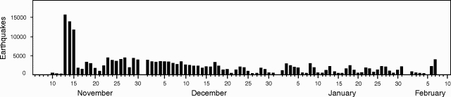 |
Figure 4. Number of daily explosion earthquakes, 10 November 1992 to 7 February 1993. Courtesy of VSI. |
Geological Summary. The renowned Krakatau (frequently mis-named as Krakatoa) volcano lies in the Sunda Strait between Java and Sumatra. Collapse of an older edifice, perhaps in 416 or 535 CE, formed a 7-km-wide caldera. Remnants of that volcano are preserved in Verlaten and Lang Islands; subsequently the Rakata, Danan, and Perbuwatan cones were formed, coalescing to create the pre-1883 Krakatau Island. Caldera collapse during the catastrophic 1883 eruption destroyed Danan and Perbuwatan, and left only a remnant of Rakata. This eruption caused more than 36,000 fatalities, most as a result of tsunamis that swept the adjacent coastlines of Sumatra and Java. Pyroclastic surges traveled 40 km across the Sunda Strait and reached the Sumatra coast. After a quiescence of less than a half century, the post-collapse cone of Anak Krakatau (Child of Krakatau) was constructed within the 1883 caldera at a point between the former Danan and Perbuwatan cones. Anak Krakatau has been the site of frequent eruptions since 1927.
Information Contacts: W. Tjetjep, VSI.