Report on Galeras (Colombia) — July 1990

Bulletin of the Global Volcanism Network, vol. 15, no. 7 (July 1990)
Managing Editor: Lindsay McClelland.
Galeras (Colombia) Three small ash emissions; high-frequency seismicity and gas pressure decrease
Please cite this report as:
Global Volcanism Program, 1990. Report on Galeras (Colombia) (McClelland, L., ed.). Bulletin of the Global Volcanism Network, 15:7. Smithsonian Institution. https://doi.org/10.5479/si.GVP.BGVN199007-351080
Galeras
Colombia
1.22°N, 77.37°W; summit elev. 4276 m
All times are local (unless otherwise noted)
Three small ash emissions, the first reported since March, occurred 11, 21, and 27 July. The volcano remained in a state of high fumarolic activity during June and July, although a slight decrease in gas pressure was noted. Incandescence continued to be visible on the W wall of the inner crater, the location of the principal fumaroles. Fumaroles were also located within the crater to the SW, and on the upper flanks of the cone (Las Deformes to the S and La Calvache to the SW). Analyses showed a magmatic content for Las Deformes gases and a more varied, dilute content for La Calvache. The SO2 flux measured by COSPEC was moderate during the single June measurement, ~1,800 t/d, and in July, ~1,400-2,700 t/d.
The number of recorded low-frequency and long-period earthquakes decreased slightly in June (1,085, down from 1,313 in May) then rose again in July (1,468; figure 20). The cumulative energy output of these events reached 1.5 x 10⁹ ergs in July. The number of high-frequency earthquakes continued to decrease, from 121 in May, to 113 in June, and 65 in July (figure 20); energy output fluctuated (9.95 x 10⁷, 2.11 x 10⁸, and 1.1 x 10⁸ ergs during May, June, and July respectively; figure 21). The earthquakes were centered below the crater, generally to the W, with a few to the SSE, at depths of less than 5 km (figure 22). Deep tremor was fairly constant at low intensity and there was an average of 10 pulses of spasmodic tremor/day through June and July (figure 23). The spasmodic tremor had periods of 0.3-0.6 seconds, with a few as high as 1.0 second, in June, and periods of 0.15-0.90 seconds in July.
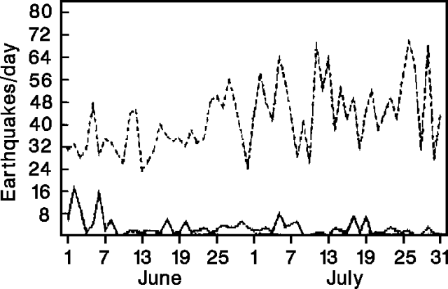 |
Figure 20. Number of earthquakes recorded/day at Galeras, June-July 1990. Lower (solid) line shows high-frequency events and upper (dashed) represents low-frequency and long-period events. Courtesy of INGEOMINAS. |
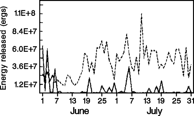 |
Figure 21. Daily energy release of earthquakes recorded at Galeras, June-July 1990. Lines same as on Figure 1. Courtesy of INGEOMINAS. |
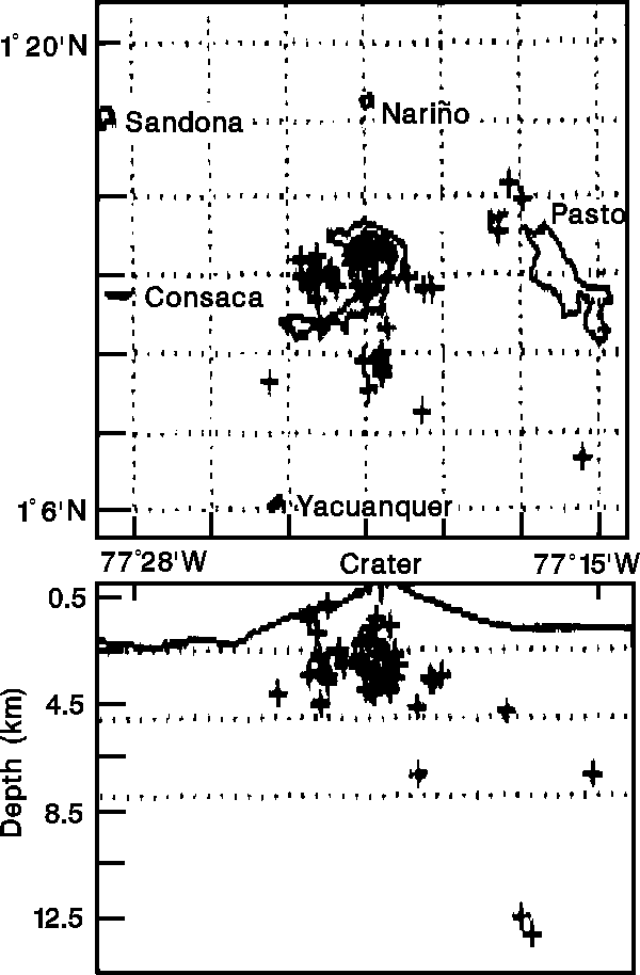 |
Figure 22. Epicenter map (top) and E-W cross-section showing focal depths (bottom) of 45 high-frequency earthquakes recorded at Galeras, July 1990. Courtesy of INGEOMINAS. |
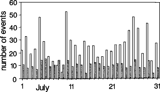 |
Figure 23. Number of long-period earthquakes (open bars) and spasmodic tremor events (shaded bars) at Galeras, July 1990. Courtesy of INGEOMINAS. |
No significant overall deformation was recorded in either June or July, although a period of moderate deformation 10-12 July coincided with the 11 July ash emission and increased numbers of long-period earthquakes. Deformation was measured at both electronic tiltmeters, but was most noticeable ~2 km E of the crater (Peladitos station) where it accumulated 7-8 µrad. The highest SO2 fluxes measured during the month were on 6 and 13 July, surrounding the period of deformation (figure 24).
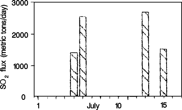 |
Figure 24. SO2 flux measurements at Galeras, July 1990. No data were taken after 15 July. Courtesy of INGEOMINAS. |
Geological Summary. Galeras, a stratovolcano with a large breached caldera located immediately west of the city of Pasto, is one of Colombia's most frequently active volcanoes. The dominantly andesitic complex has been active for more than 1 million years, and two major caldera collapse eruptions took place during the late Pleistocene. Long-term extensive hydrothermal alteration has contributed to large-scale edifice collapse on at least three occasions, producing debris avalanches that swept to the west and left a large open caldera inside which the modern cone has been constructed. Major explosive eruptions since the mid-Holocene have produced widespread tephra deposits and pyroclastic flows that swept all but the southern flanks. A central cone slightly lower than the caldera rim has been the site of numerous small-to-moderate eruptions since the time of the Spanish conquistadors.
Information Contacts: INGEOMINAS-OVP.