Report on Alamagan (United States) — September 1990
Bulletin of the Global Volcanism Network, vol. 15, no. 9 (September 1990)
Managing Editor: Lindsay McClelland.
Alamagan (United States) Seismic station installed
Please cite this report as:
Global Volcanism Program, 1990. Report on Alamagan (United States) (McClelland, L., ed.). Bulletin of the Global Volcanism Network, 15:9. Smithsonian Institution. https://doi.org/10.5479/si.GVP.BGVN199009-284180
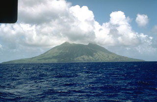
Alamagan
United States
17.6°N, 145.83°E; summit elev. 744 m
All times are local (unless otherwise noted)
Fieldwork was conducted . . . 28 September-3 October . . . . A regional network of single vertical-component, short-period seismometers was installed, with instruments located on the islands of Pagan, Alamagan, and Anatahan, and a receiving station on Saipan. . . .
Geological Summary. Alamagan is the emergent summit of a large stratovolcano in the central Mariana Islands with a roughly 350-m-deep summit crater east of the center of the island. The exposed cone is largely Holocene in age. A 1.6 x 1 km graben cuts the SW flank. An extensive basaltic-andesite lava flow has extended the northern coast of the island, and a lava platform also occurs on the S flank. Pyroclastic-flow deposits erupted about 1000 years ago have been dated, but reports of historical eruptions were considered invalid (Moore and Trusdell, 1993).
Information Contacts: R. Koyanagi, HVO.