Report on Ruapehu (New Zealand) — October 1990

Bulletin of the Global Volcanism Network, vol. 15, no. 10 (October 1990)
Managing Editor: Lindsay McClelland.
Ruapehu (New Zealand) Crater Lake temperatures rise then fall; seismicity remains low; deflation
Please cite this report as:
Global Volcanism Program, 1990. Report on Ruapehu (New Zealand) (McClelland, L., ed.). Bulletin of the Global Volcanism Network, 15:10. Smithsonian Institution. https://doi.org/10.5479/si.GVP.BGVN199010-241100
Ruapehu
New Zealand
39.28°S, 175.57°E; summit elev. 2797 m
All times are local (unless otherwise noted)
Fieldwork on 11 and 26 September, and 9 October, monitored changes in deformation and in Crater Lake. The lake appeared gray, with upwelling occurring over the N vents during all three visits, over the central vents on 11 September (when visibility was poor), and on rare occasions on 9 October. Yellow slicks were observed over the central vents on 26 September and 9 October. Undercutting of snow along the shore of the lake (around 1 m above lake level) and the wide channel cut through snow at the outlet, suggested that a surge (potentially related to minor phreatic activity) had occurred sometime before new snow (which may have fallen on 8 September) re-covered part of the exposed area.
Water temperatures increased to a maximum of 35°C by the end of September ... then decreased to 31°C by 9 October (figure 9). Lake Mg/Cl ratios were 0.052 on 26 September and 0.053 on 9 October, slightly higher than 22 August (0.051).
Seismicity has remained at very low levels since late August. A few small earthquakes (M <= 2.5) were recorded (instrument failure prevented monitoring 28 September-3 October). Tremor amplitude was low, except on 14-15 September when moderate amplitudes were recorded (figure 10).
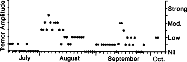 |
Figure 10. Qualitative ampliude of tremor at Ruapehu, July-October 1990. |
Deformation measurements showed that the decrease in crater width that began in early September continued through early October, although distances had not yet returned to pre-inflation, early July values (figures 9 and 11).
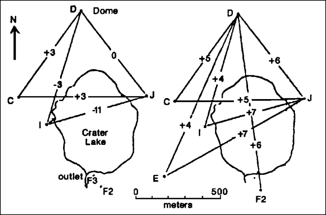 |
Figure 11. Apparent deformation (in millimeters) at Ruapehu, 22 August-9 October (left) and 20 July-9 October 1990 (right). |
Geological Summary. Ruapehu, one of New Zealand's most active volcanoes, is a complex stratovolcano constructed during at least four cone-building episodes dating back to about 200,000 years ago. The dominantly andesitic 110 km3 volcanic massif is elongated in a NNE-SSW direction and surrounded by another 100 km3 ring plain of volcaniclastic debris, including the NW-flank Murimoto debris-avalanche deposit. A series of subplinian eruptions took place between about 22,600 and 10,000 years ago, but pyroclastic flows have been infrequent. The broad summait area and flank contain at least six vents active during the Holocene. Frequent mild-to-moderate explosive eruptions have been recorded from the Te Wai a-Moe (Crater Lake) vent, and tephra characteristics suggest that the crater lake may have formed as recently as 3,000 years ago. Lahars resulting from phreatic eruptions at the summit crater lake are a hazard to a ski area on the upper flanks and lower river valleys.
Information Contacts: B. Scott and I. Nairn, DSIR Rotorua; P. Otway and S. Sherburn, DSIR Wairakei; J. Allen and R. O'Brien, Dept of Conservation, Whakapapa.