Report on Nevado del Ruiz (Colombia) — January 1991

Bulletin of the Global Volcanism Network, vol. 16, no. 1 (January 1991)
Managing Editor: Lindsay McClelland.
Nevado del Ruiz (Colombia) Minor ash emission; continued seismicity
Please cite this report as:
Global Volcanism Program, 1991. Report on Nevado del Ruiz (Colombia) (McClelland, L., ed.). Bulletin of the Global Volcanism Network, 16:1. Smithsonian Institution. https://doi.org/10.5479/si.GVP.BGVN199101-351020
Nevado del Ruiz
Colombia
4.892°N, 75.324°W; summit elev. 5279 m
All times are local (unless otherwise noted)
Sporadic minor ash emission occurred during January. Seismic activity was characterized by high-frequency events with typical low levels of energy release (figure 44). Some increases occurred to high energy levels.
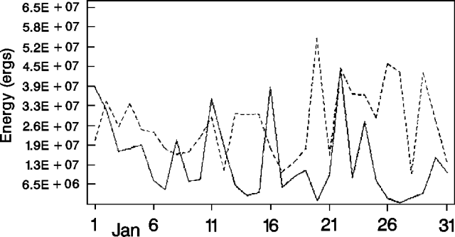 |
Figure 44. Daily seismic energy release at Ruiz, January 1991. Solid line – high-frequency events; dashed line – low-frequency events. Courtesy of INGEOMINAS. |
Tremor episodes were brief (around 10 minutes) and of low intensity during the month. Low-frequency events were uncommon and of low energy. On 16 January at 0242, a M 3.8 high-frequency event, centered 1.5 km S of Arenas crater at 3.8 km depth, was felt around the volcanic complex.
Dry-tilt stations and the electronic tiltmeters at Refugio and Recio recorded no deformation. Morphologic changes were observed at Diablos Rojos B glacier. The average rate of SO2 emission measured during the month was about 1,140 t/d, down slightly from 1,464 t/d in December.
Geological Summary. Nevado del Ruiz is a broad, glacier-covered volcano in central Colombia that covers more than 200 km2. Three major edifices, composed of andesitic and dacitic lavas and andesitic pyroclastics, have been constructed since the beginning of the Pleistocene. The modern cone consists of a broad cluster of lava domes built within the caldera of an older edifice. The 1-km-wide, 240-m-deep Arenas crater occupies the summit. The prominent La Olleta pyroclastic cone located on the SW flank may also have been active in historical time. Steep headwalls of massive landslides cut the flanks. Melting of its summit icecap during historical eruptions, which date back to the 16th century, has resulted in devastating lahars, including one in 1985 that was South America's deadliest eruption.
Information Contacts: C. Carvajal, INGEOMINAS, Manizales.