Report on Kavachi (Solomon Islands) — April 1991
Bulletin of the Global Volcanism Network, vol. 16, no. 4 (April 1991)
Managing Editor: Lindsay McClelland.
Kavachi (Solomon Islands) Submarine eruption builds new island
Please cite this report as:
Global Volcanism Program, 1991. Report on Kavachi (Solomon Islands) (McClelland, L., ed.). Bulletin of the Global Volcanism Network, 16:4. Smithsonian Institution. https://doi.org/10.5479/si.GVP.BGVN199104-255060
Kavachi
Solomon Islands
8.991°S, 157.979°E; summit elev. -20 m
All times are local (unless otherwise noted)
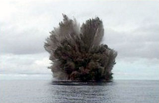
A newly emergent volcanic island near previously active Kavachi was observed ejecting lava and ash during a helicopter overflight on 4 May. John Starcy (Australian High Commissioner, Honiara, Solomon Islands) reported that "the volcanic action had already formed a thick rim of black material above sea level, inside which a large body of molten lava was churning and spewing out rocks." At the time, the island was estimated to be ~300x150 m in diameter and ~30 m high, with a lava pond ~50 m in diameter. Red Marsden (a Rabaul-based pilot) flew over the volcano on 12 May. The island had a regular conical shape that he estimated was ~15-20 m high. The volcano continued to eject incandescent lava fragments and some dark material to ~50 m height. White vapor emission occurred between ejections, and considerable steam rose from along the water line. Activity continued as of 13 May and the size of the cone continued to increase.
The location of the new island remains uncertain (figure 5) [but more precise navigation linked it to Kavachi; see 16:7]. It was reported at 8.88°S, 157.88°E, 20 km NW of Kavachi, by Starcy, and ~38 km SW of Kavachi (at 9.23°S, 157.70°E; within the Woodlark Basin) by Ted Tame (Rabaul representative of the Papua New Guinea National Disaster and Emergency Services). A submarine volcano was shown on Admiralty Chart 3995 at ~25 km W of Kavachi (at 9.0°S, 157.8°E), between the two reported positions, but the Machias 1981 bathymetry survey failed to find this feature (Exon and Johnson, 1986). Instead, the survey located a bathymetric high 10 km to the WNW that is probably a southward-trending ridge originating on Tetepare Island.
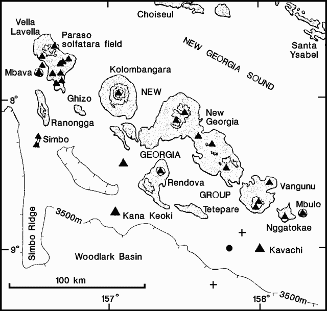 |
Figure 5. Map of the western Solomon Islands. Crosses represent reported new island locations, triangles mark the New Georgia Group volcanoes (Pliocene to Recent), and the filled circle represents the unnamed submarine volcano on Admiralty Chart 3995. Modified from Exon and Johnson (1986). |
Reference. Exon, N.E., and Johnson, R.W., 1986, The elusive Cook volcano and other submarine forearc volcanoes in the Solomon Islands: BMR Journal of Australian Geology & Geophysics, v. 10, p. 77-83.
Geological Summary. Named for a sea-god of the Gatokae and Vangunu peoples, Kavachi is located in the Solomon Islands south of Vangunu Island. Sometimes referred to as Rejo te Kvachi ("Kavachi's Oven"), this shallow submarine basaltic-to-andesitic volcano has produced ephemeral islands up to 1 km long many times since its first recorded eruption during 1939. Residents of the nearby islands of Vanguna and Nggatokae (Gatokae) reported "fire on the water" prior to 1939, a possible reference to earlier eruptions. The roughly conical edifice rises from water depths of 1.1-1.2 km on the north and greater depths to the SE. Frequent shallow submarine and occasional subaerial eruptions produce phreatomagmatic explosions that eject steam, ash, and incandescent bombs. On a number of occasions lava flows were observed on the ephemeral islands.
Information Contacts: G. Wheller, CSIRO, Australia; C. McKee, RVO.