Report on Galeras (Colombia) — April 1991

Bulletin of the Global Volcanism Network, vol. 16, no. 4 (April 1991)
Managing Editor: Lindsay McClelland.
Galeras (Colombia) Frequent ash emission and seismicity
Please cite this report as:
Global Volcanism Program, 1991. Report on Galeras (Colombia) (McClelland, L., ed.). Bulletin of the Global Volcanism Network, 16:4. Smithsonian Institution. https://doi.org/10.5479/si.GVP.BGVN199104-351080
Galeras
Colombia
1.22°N, 77.37°W; summit elev. 4276 m
All times are local (unless otherwise noted)
Following the pattern begun in March, activity continued to increase during April, when ash emissions from the main crater and associated seismicity were very frequent (table 5). Fieldwork revealed new fissures and vents on the crater's W wall, increases in the area of incandescence, and slumping of loose material. Analyses of gas samples from Deformes and Besolima fissure fumaroles suggest an increasingly magmatic composition. At Calvache fumarole, the ratio of CO2/SO2 has increased steadily (figure 36), while H2S and HCl have shown no significant variations. Besolima fissure fumarole temperatures continued to decline, from 514°C in March to 468°C on 2 April.
Table 5. Eruptive activity and associated seismicity at Galeras, 1-19 April 1991. Atmospheric conditions prevented direct observations 20-30 April. "Inc" means increased, column heights are in meters, and durations are in seconds.
| Date | Time | Activity | Column height | Signal Type | Signal Duration |
| 01 Apr 1991 | 0640 | Ash emission | -- | Long-period | 34 s |
| 01 Apr 1991 | 0905 | Inc sulfur odor | -- | Tremor | 1800 s |
| 02 Apr 1991 | 0620 | Inc column size | 300 m | Tremor | 159 s |
| 02 Apr 1991 | 0711 | Ash emission | 900 m | Tremor | 275 s |
| 02 Apr 1991 | 1014 | Ash emission | -- | Tremor | 116 s |
| 02 Apr 1991 | 1029 | Ash emission | -- | Long-period | 42 s |
| 03 Apr 1991 | 0741 | Ash emission | -- | Tremor | 89 s |
| 05 Apr 1991 | 0500 | Inc noise | -- | Tremor | 475 s |
| 06 Apr 1991 | 0002 | Inc incandescence | -- | Tremor | 182 s |
| 07 Apr 1991 | 1757 | Ash emission | 700 m | Long-period | 52 s |
| 07 Apr 1991 | 1823 | Ash emission | 500 m | Tremor | 140 s |
| 08 Apr 1991 | 1717 | Ash emission | -- | Tremor | 135 s |
| 09 Apr 1991 | 1827 | Ash emission | 400 m | Tremor | 130 s |
| 10 Apr 1991 | 0608 | Ash emission | 1100 m | Tremor | 89 s |
| 10 Apr 1991 | 0644 | Ash emission | 200 m | Tremor | 71 s |
| 10 Apr 1991 | 1010 | Ash emission | 700 m | Tremor | 230 s |
| 10 Apr 1991 | 1643 | Inc noise | -- | Tremor | 110 s |
| 10 Apr 1991 | 1820 | Ash emission | -- | Long-period | 50 s |
| 10 Apr 1991 | 1820 | Inc noise | -- | Long-period | 61 s |
| 10 Apr 1991 | 1820 | Inc incandescence | -- | Tremor | 165 s |
| 10 Apr 1991 | 1916 | Ash emission | -- | Long-period | 30 s |
| 11 Apr 1991 | 0320 | Ash emission, inc incandescence | -- | Tremor | 170 s |
| 11 Apr 1991 | 0324 | Ash emission | -- | Long-period | 17 s |
| 11 Apr 1991 | 0324 | Inc incandescence | -- | Long-period | 29 s |
| 11 Apr 1991 | 0605 | Ash emission | 200 m | Long-period | 44 s |
| 11 Apr 1991 | 0611 | Ash emission | 400 m | Long-period | 58 s |
| 11 Apr 1991 | 1508 | Ash emission | -- | Tremor | 131 s |
| 11 Apr 1991 | 1758 | Ash emission | 1700 m | Tremor | 120 s |
| 11 Apr 1991 | 1836 | Ash emission | 200 m | Long-period | 26 s |
| 11 Apr 1991 | 1841 | Ash emission | 800 m | Tremor | 115 s |
| 12 Apr 1991 | 0806 | Ash emission | -- | Tremor | 295 s |
| 12 Apr 1991 | 0826 | Ash emission | -- | Tremor | 250 s |
| 12 Apr 1991 | 0854 | Ash emission | -- | Long-period | 46 s |
| 13 Apr 1991 | 0359 | Ash emission | -- | Tremor | 625 s |
| 13 Apr 1991 | 0555 | Inc column size | 500 m | Tremor | 260 s |
| 13 Apr 1991 | 0622 | Inc column size | 400 m | Long-period | 20 s |
| 13 Apr 1991 | 0658 | Ash emission | 400 m | Long-period | 50 s |
| 13 Apr 1991 | 0958 | Ash emission, inc noise | -- | Tremor | 91 s |
| 14 Apr 1991 | 0632 | Ash emission | 800 m | Tremor | 83 s |
| 14 Apr 1991 | 0735 | Ash emission | 1100 m | Tremor | 130 s |
| 14 Apr 1991 | 0808 | Ash emission | 700 m | Long-period | 56 s |
| 14 Apr 1991 | 0845 | Ash emission, explosions, inc sulfur odor | 1500 m | Tremor | 179 s |
| 15 Apr 1991 | 0757 | Ash emission | 1500 m | Tremor | 137 s |
| 15 Apr 1991 | 1355 | Ash emission, explosions | -- | Long-period; tremor | 380 s |
| 15 Apr 1991 | 1509 | Ash emission, explosions | -- | Tremor | 82 s |
| 15 Apr 1991 | 1921 | Ash emission, inc incandescence | -- | Tremor | 130 s |
| 16 Apr 1991 | 0559 | Ash emission | -- | Tremor | 111 s |
| 16 Apr 1991 | 0711 | Ash emission | -- | Long-period | 40 s |
| 16 Apr 1991 | 0815 | Ash emission | 800 m | Long-period | 34 s |
| 16 Apr 1991 | 0835 | Ash emission | 1500 m | Tremor | 600 s |
| 16 Apr 1991 | 1004 | Ash emission | 1500 m | Tremor | 171 s |
| 16 Apr 1991 | 1107 | Ash emission | -- | Tremor | 145 s |
| 17 Apr 1991 | 0711 | Ash emission | -- | Long-period | 47 s |
| 17 Apr 1991 | 0740 | Ash emission | -- | Long-period | 57 s |
| 17 Apr 1991 | 0752 | Ash emission | -- | Tremor | 122 s |
| 17 Apr 1991 | 1742 | Ash emission | -- | Tremor | 205 s |
| 17 Apr 1991 | 1802 | Ash emission | -- | Tremor | 370 s |
| 17 Apr 1991 | 1948 | Ash emission | -- | Tremor | 1500 s |
| 18 Apr 1991 | 0706 | Ash emission | -- | Tremor | 190 s |
| 18 Apr 1991 | 0918 | Ash emission | -- | Long-period | 70 s |
| 19 Apr 1991 | 0627 | Ash emission | -- | Long-period | 21 s |
| 19 Apr 1991 | 0728 | Ash emission | -- | Tremor | 76 s |
| 19 Apr 1991 | 0855 | Ash emission | -- | Tremor | 180 s |
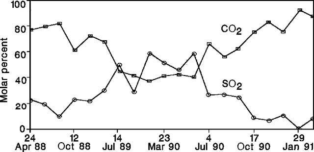 |
Figure 36. Concentration of CO2 (squares) and SO2 (circles) in Calvache fumarole gas at Galeras, April 1988-early April 1991. Courtesy of INGEOMINAS. |
A significant increase in high-frequency seismicity was recorded during the second half of April, including swarms of events on the 18th and 29th. The earthquakes (M<=2.9) were mostly located SSW of the crater at 1-5 km depth (figure 37). Long-period seismicity was at high levels, and the daily reduced displacement on 13 April was the highest recorded since monitoring began in February 1989 (figure 38). The amplitudes and durations of tremor pulses fluctuated; deep tremor and low-frequency, modulating tremor were also recorded.
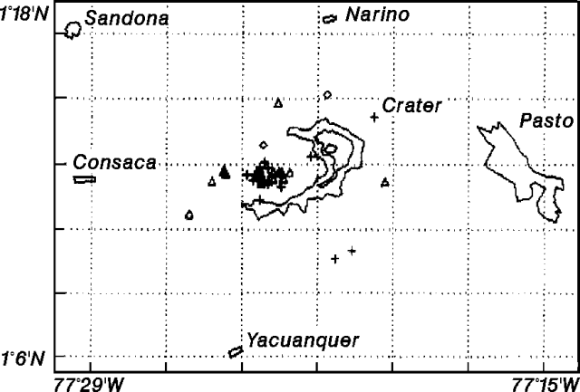 |
Figure 37. Epicenter map of 36 high-frequency earthquakes at Galeras, April 1991. Courtesy of INGEOMINAS. |
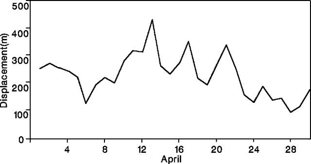 |
Figure 38. Daily reduced displacement of long-period earthquakes at Galeras, April 1991. Courtesy of INGEOMINAS. |
The electronic tiltmeter 0.9 km E of the crater (at "Crater" station) showed continued inflation, with 85 and 48 µrad of accumulated tangential and radial inflation, respectively, since September 1990 (figure 39). Three km E of the crater, dry tilt (El Pintado station) showed very low, but consistent inflation. Geologists interpreted the inflation as volcanic deformation or neotectonic tilt along the Buesaco fault.
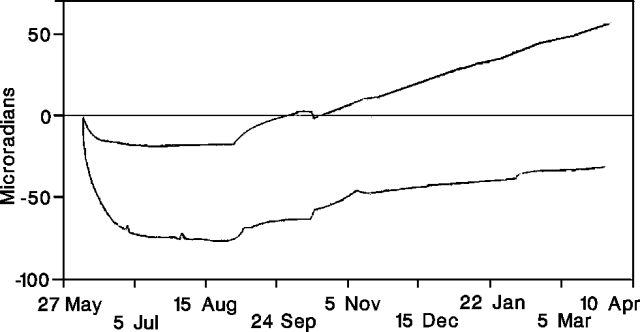 |
Figure 39. Tangential (top curve) and radial (bottom curve) deformation 0.9 km E of the crater ("Crater" electronic tiltmeter) at Galeras, May 1990-April 1991. Courtesy of INGEOMINAS. |
Geological Summary. Galeras, a stratovolcano with a large breached caldera located immediately west of the city of Pasto, is one of Colombia's most frequently active volcanoes. The dominantly andesitic complex has been active for more than 1 million years, and two major caldera collapse eruptions took place during the late Pleistocene. Long-term extensive hydrothermal alteration has contributed to large-scale edifice collapse on at least three occasions, producing debris avalanches that swept to the west and left a large open caldera inside which the modern cone has been constructed. Major explosive eruptions since the mid-Holocene have produced widespread tephra deposits and pyroclastic flows that swept all but the southern flanks. A central cone slightly lower than the caldera rim has been the site of numerous small-to-moderate eruptions since the time of the Spanish conquistadors.
Information Contacts: INGEOMINAS-OVP.