Report on Deception Island (Antarctica) — May 1991
Bulletin of the Global Volcanism Network, vol. 16, no. 5 (May 1991)
Managing Editor: Lindsay McClelland.
Deception Island (Antarctica) Stronger earthquakes; anomalous water temperature in caldera center
Please cite this report as:
Global Volcanism Program, 1991. Report on Deception Island (Antarctica) (McClelland, L., ed.). Bulletin of the Global Volcanism Network, 16:5. Smithsonian Institution. https://doi.org/10.5479/si.GVP.BGVN199105-390030
Deception Island
Antarctica
62.9567°S, 60.6367°W; summit elev. 602 m
All times are local (unless otherwise noted)
"Spanish-Argentine volcanological, geophysical, and geodetic scientists visited Deception Island during the 1990-91 austral summer (28 November 1990-13 March 1991) to provide measurements of the background activity. The present activity generally has remained unchanged from previous years.
"A digital microseismic network was installed to record the local and regional seismic activity for 3 months (figure 3). On 14 January, a M 3.2 earthquake was recorded on the NE sector of the island. After this event the seismic activity changed dramatically compared to that recorded during the previous 4 summers, increasing in magnitude and decreasing in frequency. In general, the epicenters are related to the 1970 eruption vents and they are associated with the fissure system (figure 4). Episodes of volcanic tremors were also recorded in Fumarole Bay.
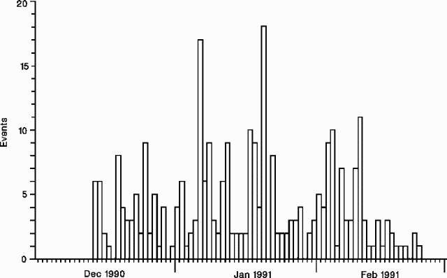 |
Figure 3. Daily number of seismic events recorded by a temporary digital microseismic network at Deception Island, 14 December 1990-23 February 1991. Courtesy of Ramón Ortiz. |
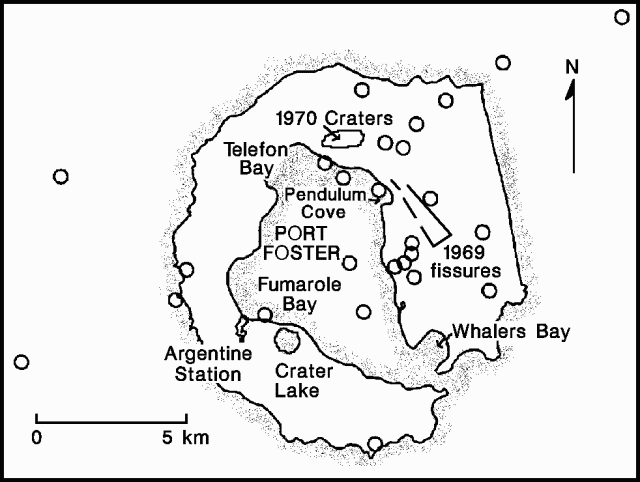 |
Figure 4. Epicenters of earthquakes (mb >1.2) recorded at Deception Island, 1 December 1990-23 February 1991. Courtesy of Ramón Ortiz. |
"During the 1990-91 fieldwork, more than 300 gravimetric measurements were carried out, the magnetic map of the island was completed, and temperatures in fumaroles and hot soils were monitored. A volcanologically oriented GPS network was established and four GPS benchmarks (Argentine Station, Pendulum Cove, Fumarole Bay, and Whalers Bay) were measured with double-frequency receivers. Finally, three dry-tilt stations were installed in Telefon Bay (1970 eruption area), Crater Lake (1842 eruption sector), and Fumarole Bay.
"The Spanish Oceanographic vessel Las Palmas recorded water temperature and salinity distribution in Port Foster. An area of anomalous temperature was detected in the central part of the caldera."
Geological Summary. Ring-shaped Deception Island, at the SW end of the South Shetland Islands, NE of Graham Land Peninsula, was constructed along the axis of the Bransfield Rift spreading center. A narrow passageway named Neptunes Bellows provides an entrance to a natural harbor within the 8.5 x 10 km caldera that was utilized as an Antarctic whaling station. Numerous vents along ring fractures circling the low 14-km-wide island have been reported active for more than 200 years. Maars line the shores of 190-m-deep Port Foster caldera bay. Among the largest of these maars is 1-km-wide Whalers Bay, at the entrance to the harbor. Eruptions during the past 8,700 years have been dated from ash layers in lake sediments on the Antarctic Peninsula and neighboring islands.
Information Contacts: R. Ortiz, Museo Nacional de Ciencias Naturales, Spain; J. Viramonte, Univ Nacional de Salta, Argentina; R. Soto, Real Instituto y Observatorio de la Armada, Spain.