Report on Kavachi (Solomon Islands) — July 1991
Bulletin of the Global Volcanism Network, vol. 16, no. 7 (July 1991)
Managing Editor: Lindsay McClelland.
Kavachi (Solomon Islands) May-June submarine eruption ends; temporary island eroded away
Please cite this report as:
Global Volcanism Program, 1991. Report on Kavachi (Solomon Islands) (McClelland, L., ed.). Bulletin of the Global Volcanism Network, 16:7. Smithsonian Institution. https://doi.org/10.5479/si.GVP.BGVN199107-255060
Kavachi
Solomon Islands
8.991°S, 157.979°E; summit elev. -20 m
All times are local (unless otherwise noted)
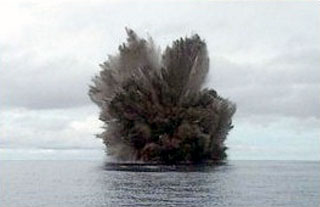
An eruption built a small temporary island . . . first observed on 4 May, but its location was initially uncertain. However, more precise navigational data from the chief pilot of Western Pacific Air Services placed the activity at 9.00°S, 157.97°E, roughly 3 km NE of Kavachi's summit.
Activity apparently had not changed when, during an overflight on 5 June, [John] Monroe observed a vigorously active lava fountain roughly 25 m high and a plume that rose >2,500 m. The island's dimensions were estimated at 150-200 m long and ~50 m high. Carl Rossiter reported that divers ~45 km NE of Kavachi (at Kicha Island) felt powerful explosions while underwater on 7-8 and 12-13 June. Individual explosions occurred a few seconds apart in groups of 12-20. Explosion groups generally lasted a total of 1-2 minutes, were typically preceded and followed by rumbling, and were separated by roughly 30 minutes of quiet. No explosions were felt at other dive sites, where islands were between the observers and Kavachi.
The eruption weakened in mid-June, and the island disappeared beneath the ocean surface later in the month. No additional activity has been reported.
Geological Summary. Named for a sea-god of the Gatokae and Vangunu peoples, Kavachi is located in the Solomon Islands south of Vangunu Island. Sometimes referred to as Rejo te Kvachi ("Kavachi's Oven"), this shallow submarine basaltic-to-andesitic volcano has produced ephemeral islands up to 1 km long many times since its first recorded eruption during 1939. Residents of the nearby islands of Vanguna and Nggatokae (Gatokae) reported "fire on the water" prior to 1939, a possible reference to earlier eruptions. The roughly conical edifice rises from water depths of 1.1-1.2 km on the north and greater depths to the SE. Frequent shallow submarine and occasional subaerial eruptions produce phreatomagmatic explosions that eject steam, ash, and incandescent bombs. On a number of occasions lava flows were observed on the ephemeral islands.
Information Contacts: R. Addison and A. Papabatu, Ministry of Natural Resources, Honiara; J. Monroe, San Jose, USA; C. Rossiter, See and Sea Travel Service, San Francisco, USA.