Report on Cerro Hudson (Chile) — September 1991
Bulletin of the Global Volcanism Network, vol. 16, no. 9 (September 1991)
Managing Editor: Lindsay McClelland.
Cerro Hudson (Chile) New mudflow and gas emission; details of major mid-August tephra fall
Please cite this report as:
Global Volcanism Program, 1991. Report on Cerro Hudson (Chile) (McClelland, L., ed.). Bulletin of the Global Volcanism Network, 16:9. Smithsonian Institution. https://doi.org/10.5479/si.GVP.BGVN199109-358057
Cerro Hudson
Chile
45.9°S, 72.97°W; summit elev. 1905 m
All times are local (unless otherwise noted)
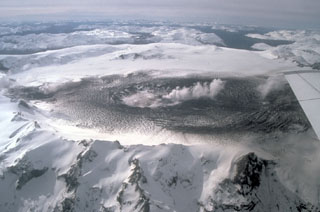
In the first new activity since the paroxysmal event of 12-15 August, a small eruption occurred several days before 6 October, emitting ash that was carried 8 km SE. The probable source was the new vent in the SW part of the caldera, which showed numerous fumaroles, especially along the S wall, during a helicopter overflight on 14 September. At about 2200 on 11 October, a mudflow, estimated to be 2-3 times larger than the 8 August mudflow (16:7), traveled 20 km NW down the Huemules valley, and SSW down the Cupquelán valley to reach the coast at Bahía Erasmo (45 km from the volcano). During the evening a brief ashfall was reported 60 km SSE (at Bahía Murta), and a strong degassing event occurred within the caldera. Sulfurous fumes were very intense in the Huemules valley, where some inhabitants became sick, vomiting and losing consciousness. On 12 October, a sulfur odor was detected in Cochrane (150 km S) and at Coyhaique (75 km NE), but it had disappeared by 13 October. Several small earthquake swarms were recorded between 0400 and 1130 on 12 October.
A 16 October helicopter overflight of the mudflow deposits showed them to include ash, snow (ice), and mud; five dead animals were observed together with some others trapped in the mud. Bad weather conditions hindered direct observation of the caldera in October, and as of the 21st it was not certain whether the mudflow was caused by fumarolic activity (which apparently triggered a mudflow in 1973) or new lava emission (as in 1971 and on 8 August 1991). Seismicity fluctuated below ~ 10 recorded earthquakes/day through mid-October (figure 6), typical of levels since a rapid decrease following the paroxysmal eruption 12-15 August.
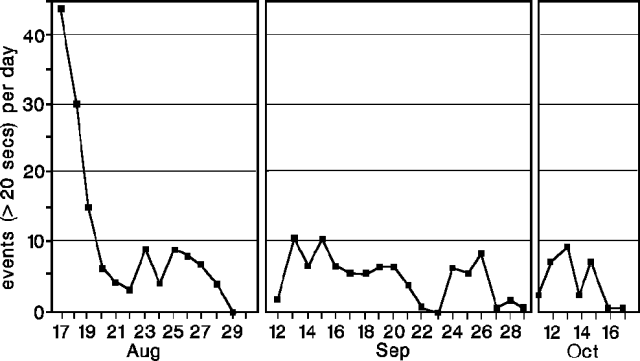 |
Figure 6. Daily number of earthquakes at Hudson, 17 August-17 October 1991. No data exist for 1-11 September or 1-10 October. A swarm recorded between 0400 and 1130 on 12 October is not included. Data for 11 October are for 1200-midnight; data for 17 October are for midnight-1020. August-September data are from Héctor Massone; October data are from Mario Villouta. All data were collected at a seismic station 50 km NE of the volcano near Lago Elizalde. |
The following, from the Geological Team of the Santa Cruz Volcanic Emergency Commission, describes the impact of the Hudson eruption in Argentina.
The eruption's first effect in Argentina was reported on 9 August at 1600, when an Aerolineas Argentinas aircraft flew through a dense SO2-rich cloud at ~ 10.5 km altitude, near 40°S, 69°W. NOAA 10 and 11 satellite images of the eruption's basaltic phase on 8-9 August showed a narrow 550-km-long plume extending NE across the central area of Chubut Province (Argentina). The 12-15 August paroxysmal trachyandesitic eruptive phase produced a dense plume of gas and ash that was transported ESE by the jet stream at nearly 200 km/hour, at ~ 8 km altitude near the caldera and rising progressively to more than 12 km at the Chile-Argentina border. This dense, elongate plume traveled in the lower stratosphere (12-16 km) without great dispersion, spanning a horizontal angle of only 15° during 12-15 August. As a consequence, tephra fall was concentrated in a narrow fan-shaped sector of Patagonia, extending to Puerto Deseado (580 km ESE) and San Julián (550 km SE) on the Atlantic coast. By the end of the eruption, 100,000 km2 of Santa Cruz Province, Argentina, had been covered by an ash blanket 0.1-10 cm thick, and a 6.5-km-thick stratus cloud of suspended particles remained.
Deposits. On 16 August, shortly after tephra fall had effectively ceased, a strong wind began to blow (surface winds of up to 110 km/hour are common in Patagonia), lasting for a week. When the winds stopped, four multidisciplinary groups of the Santa Cruz Volcanic Emergency Commission were able to enter the affected area, employing specially dust-protected trucks. A survey was performed between 25 August and 1 September along access roads; the main technical problem in making isopach and volumetric estimations was correcting for remobilization of the primary tephra-fall deposits by the violent winds.
Sampling was performed, on individual layers or on the whole deposit, with an attempt to avoid remobilized materials. Isopach curves differ from the usual pattern, in which thickness rapidly decreases with distance from the vent. Instead, some maxima were found 500 km from the volcano, close to the Atlantic coast. This is probably a consequence of a special air-circulation condition: low-density pumice fragments transported by a powerful jet stream. In Santa Cruz Province, ash deposits originally ranged from 0.1 to 11 cm thick, but accumulations up to 150 cm thick were observed on the protected, downwind sides of obstacles in the zones affected by remobilization. The volume of the accumulated ash deposits was estimated at 2.8 km3, equivalent to ~ 2.3 x 10¹² kg of ash deposited over a 100,000 km2 area.
Nature of the materials. Investigation of the internal structure of the deposits revealed strong grading with a sharp transition between sand-sized and silt-sized layers. Bimodality is also reflected in the grain-size distribution, with one mode for sand and one mode for silt, and a remarkably low content of very fine sand. The layers indicated at least 5 strong pulses of eruptive activity.
The proportion of fine material clearly increases with distance to the eruptive center. Following this trend, the maximum pumice-fragment size diminished from around 3 mm near Lago Buenos Aires (a 110-km lake, 65 km from the volcano at its closest point) to ~ 0.3 mm along the Atlantic coast.
Density measured on 39 pumice samples ranged from 0.61 to 1.05 g/cm3. Coarse floating pumice, occasionally forming rafts, was observed in Lago Buenos Aires.
Mineralogical composition was determined for the very fine sand fraction (0.062-0.125 mm), which consists of vitric particles (87%) and crystals (13%) with rare lithics. The vitric particles are composed of pumice (~70%) and cuspate to platy shards (30%). Most pumice particles have a fibrous texture with tubular vesicles of subparallel orientation and longitude/diameter ratios larger than 10/1. Crystals are fresh, euhedral, commonly broken, and often have glass rinds. The main components are feldspar, olivine, ortho- and clinopyroxene, and magnetite. Biotite, tridymite and unidentified iron/manganese oxides are less abundant.
Regional impact. The consequences of the eruption on Argentine territory, together with the difficult meteorological conditions that usually affect this region, produced a serious and persistent situation. The tephra fall hindered transportation and caused the collapse of some house roofs due to the weight of the ash accumulations. Ashfall and/or the later remobilization by winds polluted the atmosphere, causing respiratory ailments, damage by abrasion to engines and mechanical devices, and other problems. Low visibility provoked numerous accidents and aviation inconveniences. Problems persisted in mid-October.
The eruption has caused many difficulties for livestock (principally sheep and cattle) and wildlife, including: thirst, because the great water absorption capacity of the fine pumice particles dried every source of water in this already desert area; hunger, because the tephra deposit covered the grass, preventing ingestion or obliging the animals to swallow a large proportion of ash; blindness, due to the abrasive action of the glass shards and minerals, continuously blown by the wind, on the cornea; and immobilization due to increase in weight by accumulation of ash into the wool fleece, impeding movement. As a consequence, 50% of the sheep and cattle had died within 30 days of the end of the Hudson eruption. [see also 16:10]
Vegetation in this desert region (<150 mm/year precipitation) was initially covered by a thin layer of ash that retained moisture. However, the strong winds removed this protective cover, damaging pastures by the impact of the particles and by completely burying them under dune formations.
Other phenomena related to the Hudson eruption were:
Earthquakes. In Bajo Caracoles, 200 km ESE of Hudson, shocks of medium intensity destroyed some adobe buildings. People from these rural areas reported loud noises and ground vibrations.
Acid rain. The odor of sulfurous gas was noticeable everywhere in the area affected by ashfalls, but acid rain was only reported in Gobernador Gregores, 360 km ESE of the volcano, where H2SO4 produced light face and hand burns, and damaged roof paint.
Atmospheric contamination. After the tephra fall stopped (August 15), remobilization of fine ash occurred each time the W wind blew at speeds higher than 35 km/hour, causing the formation of huge dust clouds. The population was warned to employ protective dust masks to prevent respiration of the fine glass shards in these clouds (<5 mm, in average concentrations of 300 p/cm3 with maximum of 1,500 p/cm3). This last phenomenon has had the largest impact on the rural and urban population, not counting the economic losses suffered.
Geological Summary. The ice-filled, 10-km-wide caldera of Cerro Hudson volcano was not recognized until its first 20th-century eruption in 1971. It is the southernmost volcano in the Chilean Andes, related to subduction of the Nazca plate beneath the South American plate. The massive volcano covers an area of 300 km2. The compound caldera is drained through a breach on its NW rim, which has been the source of mudflows down the Río de Los Huemeles. Two cinder cones occur N of the volcano and others occupy the SW and SE flanks. This volcano has been the source of several major Holocene explosive eruptions. An eruption about 6,700 years ago was one of the largest known in the southern Andes during the Holocene; another eruption about 3,600 years ago also produced more than 10 km3 of tephra. An eruption in 1991 formed a new 800-m-wide crater in the SW portion of the caldera.
Information Contacts: H. Corbella, R. Scasso, P. Rial, M. Palacios, M. Lucero, P. Tiberi, and D. Perez, Geological Team of the Santa Cruz Volcanic Emergency Commission, Argentina; J. Naranjo, SERNAGEOMIN ; M. Villouta, Univ de la Frontera; H. Moreno, Univ de Chile; H. Massone, Univ de Chile; G. Villaroes Pinilla, ONEMI, Santiago; R. Osorio Araneda, Coyhaique, Chile; N. Banks, USGS.