Report on Nyamulagira (DR Congo) — October 1991

Bulletin of the Global Volcanism Network, vol. 16, no. 10 (October 1991)
Managing Editor: Lindsay McClelland.
Nyamulagira (DR Congo) Earthquake swarm, then fissure eruption feeds lava flows
Please cite this report as:
Global Volcanism Program, 1991. Report on Nyamulagira (DR Congo) (McClelland, L., ed.). Bulletin of the Global Volcanism Network, 16:10. Smithsonian Institution. https://doi.org/10.5479/si.GVP.BGVN199110-223020
Nyamulagira
DR Congo
1.408°S, 29.2°E; summit elev. 3058 m
All times are local (unless otherwise noted)
The following paragraph, from M. Kasahara, K. Tanaka, and N. Zana supplements last month's report.
After 25 months of quiet, an eruption began at 0130 on 20 September, from a N30°E fissure [see slightly revised trend in 17:1] ~15 km NE of the summit caldera and 5 km NE of the 1958 (Kitsimbanyi) eruption site (figure 8). An earthquake swarm began about a week before the eruption (figure 9), but gradually declined between 16 September and eruption's onset, with changing seismic waveforms reflecting a shift to lower frequencies. The start of the eruption was witnessed from ~10 km SE (at Rumangabo) and clearly recognized by the appearance of continuous tremor on a seismograph (BLG) operated by the CRSN 40 km SSW of the eruption site. Tremor amplitude was half its initial value a day after the eruption began, but tremor was continuing in late September (figure 10). Lava fountain activity continued at the N end of the fissure [but see 17:1], producing a new cone and two lava flows. During the first week of the eruption, the new cone (named Mikombe; "many bats") grew to 60-70 m height with basal dimensions of 400 x 300 m (figure 11). Lava extended 6-7 km NE, along and over the 1958, 1967, and 1980 flows. The eruption remained vigorous on 30 September when initial field studies ended.
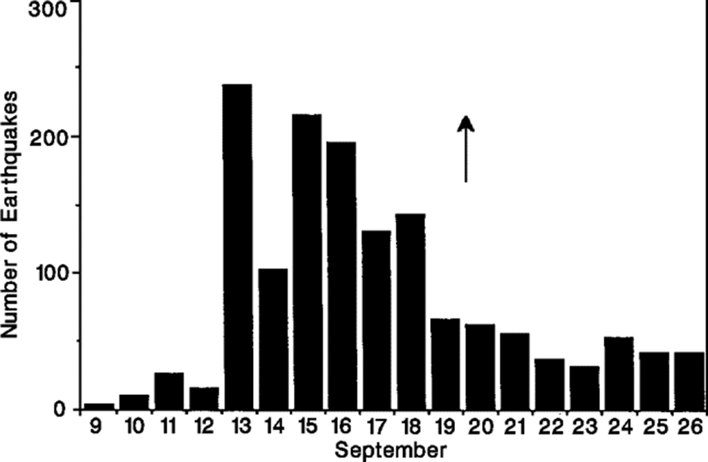 |
Figure 9. Daily number of earthquakes recorded at a seismic station (BLG), ~40 km SW of Nyamuragira's 1991 eruption site, 9-27 September 1991. Courtesy of M. Kasahara. |
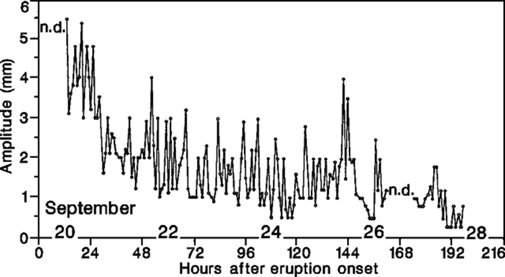 |
Figure 10. Hourly variation in tremor amplitude recorded (at station KTL) roughly 15 km ESE of Nyamuragira's 1991 eruption site, from 12 hours after the onset of the eruption through early 28 September. Courtesy of M. Kasahara. |
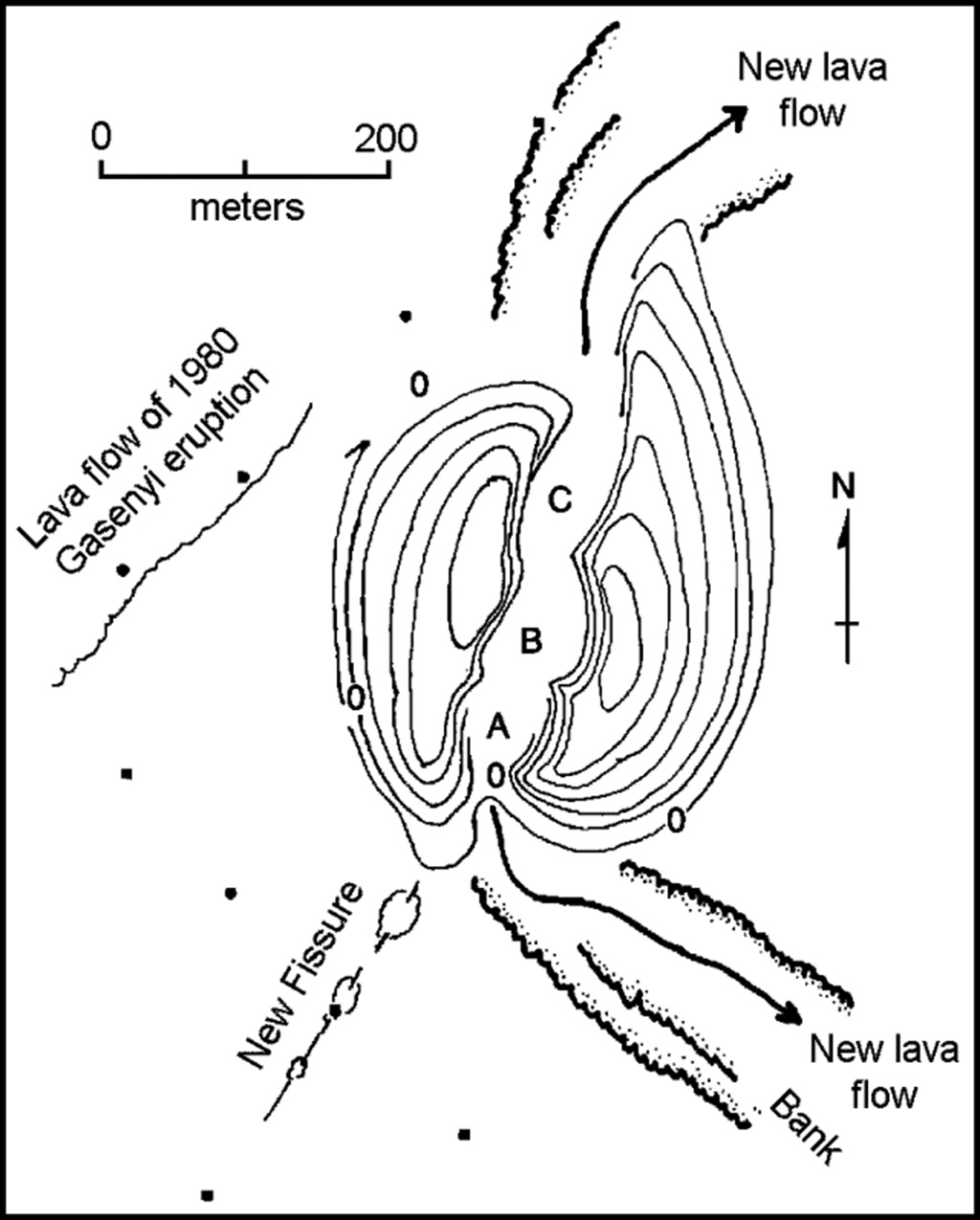 |
Figure 11. Topographic sketch map of the Mikombe cone 15 km NE of Nyamuragira's summit, 27 September 1991. Contour interval is 10 m, with 0 representing the pre-eruption base level. Data points are elevations, in meters above base level. Courtesy of M. Kasahara. |
Airline flight crews reported plumes to 7.5 km altitude on 15 and 20 October. On 21 October, CRSN geologists reported that activity was increasing, and lava had cut the road to Tongo. A new vent, SW of Mikombe, opened on 23 October [see also 17:1] and, as of 31 October, activity continued to increase at both vents. Pilot reports suggested that the ash cloud was only 200 m high by 2 November.
Given the first week's lava output, geologists expected the total volume to be of the same order as previous eruptions. The current eruption was believed to be a continuation of the highly active period that began with the 1976 eruption. Since then, seven flank eruptions have occurred in 15 years, 2-3 times the 1900-76 rate (Krafft, 1990).
Reference. Krafft, M., 1990, Führer zu den Virunga-Vulkanen: Ferdinand Enke Verlag, Stuttgart, 192 p.
Geological Summary. Africa's most active volcano, Nyamulagira (also known as Nyamuragira), is a massive high-potassium basaltic shield about 25 km N of Lake Kivu and 13 km NNW of the steep-sided Nyiragongo volcano. The summit is truncated by a small 2 x 2.3 km caldera that has walls up to about 100 m high. Documented eruptions have occurred within the summit caldera, as well as from the numerous flank fissures and cinder cones. A lava lake in the summit crater, active since at least 1921, drained in 1938, at the time of a major flank eruption. Recent lava flows extend down the flanks more than 30 km from the summit as far as Lake Kivu; extensive lava flows from this volcano have covered 1,500 km2 of the western branch of the East African Rift.
Information Contacts: M. Kasahara and K. Tanaka, Hokkaido Univ; ICAO; H-L. Hody, GEOVAR, Kigali, Rwanda.