Report on Galeras (Colombia) — October 1991

Bulletin of the Global Volcanism Network, vol. 16, no. 10 (October 1991)
Managing Editor: Lindsay McClelland.
Galeras (Colombia) New lava dome in summit crater; strong SO2 emission
Please cite this report as:
Global Volcanism Program, 1991. Report on Galeras (Colombia) (McClelland, L., ed.). Bulletin of the Global Volcanism Network, 16:10. Smithsonian Institution. https://doi.org/10.5479/si.GVP.BGVN199110-351080
Galeras
Colombia
1.22°N, 77.37°W; summit elev. 4276 m
All times are local (unless otherwise noted)
The summit crater lava dome continued to grow through the second week of November, and was ~50 m thick by 23 October (figure 46). The surface of the dome was covered by angular blocks, some >4 m in diameter, most notable on the dome's E and SE edges. The central portion of the dome was covered by smaller fragments. The dome was first observed during an overflight on 9 October, but the start of dome growth may have been 3-4 October when high levels of sustained tremor (episodes of ~2 Hz lasting to 30 minutes) were recorded.
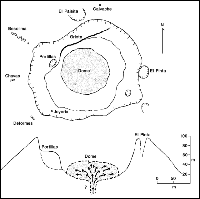 |
Figure 46. Sketch of the crater area of Galeras, showing dome and fumarole locations on 23 October 1991. Courtesy of INGEOMINAS. |
Gas and ash emissions occurred from different points on the dome surface, occasionally ejecting blocks to short distances. Surface activity closely corresponded with tremor and long-period seismic events that were recorded about 10-15 times/hour. Seismic energy release and the number of earthquakes continued to increase in October (see figure 52), again establishing new monthly highs at Galeras.
Electronic tiltmeters showed continued deformation during October, with 234 µrad of accumulated inflation at 190° azimuth measured [at Crater Station]; (figure 47), and 41 µrad at 292° azimuth measured [at Peladitos Station]. Slight inflation was also measured 2.3 km E of the crater (at "Piedras"). A decrease in the rate of inflation at Crater Station occurred on 9 October.
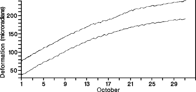 |
Figure 47. Tangential (top curve) and radial (bottom curve) deformation measured 0.9 km E of the crater (by the "Crater" electronic tiltmeter) at Galeras, October 1991. Courtesy of INGEOMINAS. |
The daily average SO2 flux varied widely from ~100 t/d (23 October) to ~1,700 t/d (28 October; figure 48), reaching higher values than in August or September (maxima of 370 and 1,045 t/d respectively). Airborne COSPEC measurements on 12 November indicated SO2 fluxes of up to 2,500 t/d.
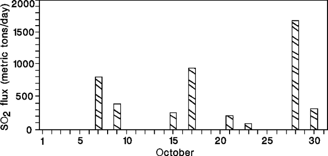 |
Figure 48. Daily average SO2 flux at Galeras, October 1991. No measurements were made on days without data. Courtesy of INGEOMINAS. |
Reference. Calvache, M.L., 1990, Geology and volcanology of the recent evolution of Galeras volcano, Colombia: M.S. Thesis, Louisiana State University, Baton Rouge, LA, 172 p.
Geological Summary. Galeras, a stratovolcano with a large breached caldera located immediately west of the city of Pasto, is one of Colombia's most frequently active volcanoes. The dominantly andesitic complex has been active for more than 1 million years, and two major caldera collapse eruptions took place during the late Pleistocene. Long-term extensive hydrothermal alteration has contributed to large-scale edifice collapse on at least three occasions, producing debris avalanches that swept to the west and left a large open caldera inside which the modern cone has been constructed. Major explosive eruptions since the mid-Holocene have produced widespread tephra deposits and pyroclastic flows that swept all but the southern flanks. A central cone slightly lower than the caldera rim has been the site of numerous small-to-moderate eruptions since the time of the Spanish conquistadors.
Information Contacts: INGEOMINAS-OVP; S. Williams and M. Calvache, Arizona State Univ.