Report on Heard (Australia) — May 1992
Bulletin of the Global Volcanism Network, vol. 17, no. 5 (May 1992)
Managing Editor: Lindsay McClelland.
Heard (Australia) Plumes and glow; volcano morphology and 1986-87 activity described; 1992 summit eruption
Please cite this report as:
Global Volcanism Program, 1992. Report on Heard (Australia) (McClelland, L., ed.). Bulletin of the Global Volcanism Network, 17:5. Smithsonian Institution. https://doi.org/10.5479/si.GVP.BGVN199205-234010
Heard
Australia
53.106°S, 73.513°E; summit elev. 2745 m
All times are local (unless otherwise noted)
[The following from Graeme Wheller] includes observations of continued activity in late 1986 and early 1987, and a renewed eruption in 1992.
Volcano morphology. Heard Island consists of two volcanic cones, Big Ben and Mt. Dixon, joined by a narrow isthmus (figure 2). Both cones are young, but only Big Ben has been observed to erupt. Many young lavas, including two that are unvegetated, lie on the flanks of Mt. Dixon. The separation of the two volcanoes is evident from the contrasting petrographic, geochemical, and isotopic characteristics of their respective eruptives [(Barling and others, 1994)].
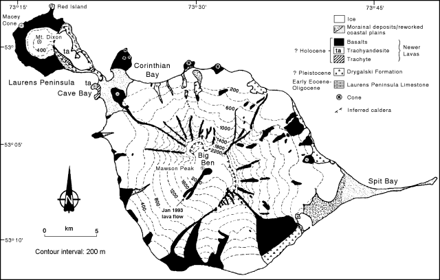 |
Figure 2.Geologic sketch map of Heard Island (after Barling, 1990) showing the location of the lava flow observed by Rod Ledingham in mid-January 1993. |
Big Ben is a large, glacier-covered, composite cone 20-25 km in diameter at sea-level, consisting mainly of basaltic lavas and lesser ash and scoria. Its summit region consists of a SW-facing semi-circular ridge 5-6 km in diameter, 2,200-2,400 m asl. The ridge appears to have formed from breaching of the SW flank of Big Ben, possibly by landsliding caused by seismicity or a laterally directed blast. The E, N, and W flanks of Big Ben have been deeply scoured by glacial erosion, forming high-standing radial ribs to 7-8 km long.
Eruptions have built a new regularly shaped cone, Mawson Peak, within the breached region of the summit. Mawson Peak is snow-and ice-covered on all sides, . . . and its SW flank slopes smoothly to the coast. All . . . historical volcanism has apparently originated at the summit of Mawson Peak.
Young volcanic deposits. Mt. Dixon, much smaller than Big Ben, appears to be the latest manifestation of volcanic activity that has created a peninsula 9 km long and up to 5 km wide extending from the NW side of Big Ben. Mt. Dixon, at the end of the peninsula, is a glacier-covered rounded cone 706 m tall. More than 20 separate relatively young basaltic lava flows have been identified on its flanks, including two that are largely vegetation-free and may have been erupted within the last few hundred years. These lavas have flowed from vents on the upper flanks of Mt. Dixon, except for one from a fissure marked by an elongate scoria ridge ~1 km long near the base of the S flank. A crater ~50 m in diameter occurs at the head of one W-flank flow ~1 km inland. Several small hornitos occur on the lava flow near this crater. One is still well-formed, ~2.5 m high and 3-4 m in diameter, but the others have largely collapsed. On the W and N flanks of Mt. Dixon, particularly near Red Island, trachytic lavas lie beneath the basalt lavas.
Eleven parasitic scoria cones and associated small basaltic lava flows occur around the coastline . . . . Some are at or near the edges of vertical sea cliffs, indicating that erosion by the sea may have obliterated other cones. The parasitic cones are typically ~100 m high and well-formed with deep central craters. Lava spatter usually occurs abundantly around the upper parts of the cones. Lavas produced from these vents are typically small-volume pahoehoe flows. From their morphology and relative lack of vegetation, the cones and their lavas may be only a few thousand years old. On Azorella Peninsula, the parasitic cone forms the W side of Corinth Head which, together with Rogers Head, appears to be a remnant of an older and much larger cone formed of thinly stratified leucocratic tuff. The basaltic flow erupted from the Corinth Head crater contains partly collapsed tumuli and lava tunnels.
A similarly youthful, trachytic, airfall (Plinian?) pumice deposit 1-1.5 m thick occurs at the E end of the island. The lower 0.5 m of the deposit is distinctly darker than the upper part, showing a sharp horizontal transition. The deposit is overlain by moraine but underlying material is not visible. Similar deposits are not known from any other parts of the island. Although it is primary deposit and must therefore have been produced by an eruption on Heard Island, the location of its originating vent is not known.
December 1986-January 1987 activity. A deep, well-formed crater at the top of Mawson Peak was discovered on helicopter overflights in December 1986 and January 1987, during the 1986/87 Heard Island ANARE. On 21 December, a brief landing was made on the summit beside the crater. The crater was cylindrical and, from visual estimates, ~40-50 m in diameter and 50-70 m deep, with vertical walls exposing dark horizontal ash layers thinly coated in yellow sulfur. The crater was floored by a black ropy lava surface in which small patches of red lava periodically appeared, indicating an active lava lake within the crater. Larger red patches, ~ 5-10 m across, appeared less frequently, accompanied by gentle emissions of a little blue smoke. Minor steam emission also occurred from around the crater rim and from a rocky area on the crater's E side. The crater appears to have been formed by the 1985/87 eruption because it was not seen by climbing parties that reached the summit of Mawson Peak in 1965 and 1983.
A new pahoehoe lava flow in a glacial valley on Mawson Peak's SW flank was also discovered during the 1986/87 ANARE. The flow extended ~8-9 km from the summit crater rim, where it exited through a deep V-shaped notch, to within 2-3 km of the coast (near Cape Arkona). Small amounts of steam emanated from parts of the flow, which probably formed in January 1985, as observed from the Marion Dufresne.
1992 summit activity. Satellite images and observations from the ANARE base revealed eruptive activity in 1992. Data from the NOAA 11 polar orbiter showed plumes extending 300 km NNE then E from the island on 17 January at about 1720, and 200 km NE the next day at 0300. Weather in the region is usually cloudy, and no other activity was evident . . . until a short-lived thermal anomaly was detected on 18 May at 2146. The ANARE team had not yet reached Heard Island on 17 January, but the summit area was visible for 20 days in March, 18 days in April, and 7 days in May (as of the 29th). Gas had been emerging from the summit during fieldwork in mid-1990, but no activity was evident in 1992 until 29 May, when an orange glow was first noticed above the mountain at 2130. The glow rapidly intensified and appeared to be pulsating, faded after about a minute, then reappeared a few minutes later. Three or four such cycles were observed, with glow intensity changing randomly. Glow faded for the last time at about 2200. Although some auroral activity occurred that night, none of the observers believed that it was the source of the glow. Activity was next reported on 8 June, when vapor began to emerge from the summit at about 1430, soon forming a plume to the SE. Mist soon obscured the activity. Traces of steam were also visible on 10 June.
Reference. Barling, J., 1990, Heard and McDonald Islands, in Le Masurier, W., and Thomson, J., eds., Volcanoes of the Antarctic Plate and southern Oceans: American Geophysical Union, Washington DC, p. 435-441.
Further References. Barling, J., Goldstein, S.L., and Nicholls, I.A., 1994, Geochemistry of Heard Island (southern Indian Ocean): characterisation of an enriched mantle component and implications for enrichment of sub-Indian Ocean mantle: Journal of Petrology, v. 35, p. 1017-1053.
Hilton, D.R., Barling, J., and Wheller, G.E., 1995, Effect of shallow-level contamination on the helium isotope systematics of ocean-island lavas: Nature, v. 373, p. 330-333.
Geological Summary. Heard Island on the Kerguelen Plateau in the southern Indian Ocean consists primarily of the emergent portion of two volcanic structures. The large glacier-covered composite basaltic-to-trachytic cone of Big Ben comprises most of the island, and the smaller Mt. Dixon lies at the NW tip of the island across a narrow isthmus. Little is known about the structure of Big Ben because of its extensive ice cover. The active Mawson Peak forms the island's high point and lies within a 5-6 km wide caldera breached to the SW side of Big Ben. Small satellitic scoria cones are mostly located on the northern coast. Several subglacial eruptions have been reported at this isolated volcano, but observations are infrequent and additional activity may have occurred.
Information Contacts: G. Wheller, CSIRO Division of Exploration Geoscience, Australia; R. Varne, Univ of Tasmania; A. Vrana, K. Green, and T. Jacka, Australian Antarctic Division, Tasmania; W. Gould, NOAA/NESDIS.