Report on Galeras (Colombia) — July 1992

Bulletin of the Global Volcanism Network, vol. 17, no. 7 (July 1992)
Managing Editor: Lindsay McClelland.
Galeras (Colombia) More details of 16 July explosion; previous activity summarized
Please cite this report as:
Global Volcanism Program, 1992. Report on Galeras (Colombia) (McClelland, L., ed.). Bulletin of the Global Volcanism Network, 17:7. Smithsonian Institution. https://doi.org/10.5479/si.GVP.BGVN199207-351080
Galeras
Colombia
1.22°N, 77.37°W; summit elev. 4276 m
All times are local (unless otherwise noted)
Most of the 1991 summit lava dome was ejected by an explosion on 16 July. The following summarizes activity since 1989 and provides additional detail about the July explosion.
Previous activity, 1989 to mid-1992. Increased fumarolic activity accompanied by minor ash emission and seismicity began in February 1989. Emission of ash that consisted of lithic fragments and some crystals occurred in early May. The ash was dispersed toward the SW, N, and E (onto Pasto. . .). The minimum volume of the ashfall was estimated at 4 x 10⁵ m3. Fumarolic activity continued for the rest of 1989. In 1990, small to moderate ash emissions were associated with long-period earthquakes and tremor pulses. Blocks to 15 cm in diameter were deposited around the crater by a small explosion on 2 August 1990. Another explosion on 25 November produced small quantities of juvenile glass. The finest ash was deposited on Pasto, producing a thin, discontinuous cover <1 mm thick. Ash emissions were frequent during the next 12 months, associated with long-period signals and tremor episodes that increased in number and size through November 1991 (figures 56 and 57).
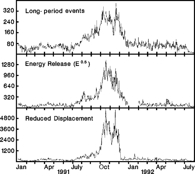 |
Figure 56. Daily number (top), energy release (middle), and reduced displacement (bottom) of long-period seismic events at Galeras, January 1991-July 1992. Courtesy of INGEOMINAS. |
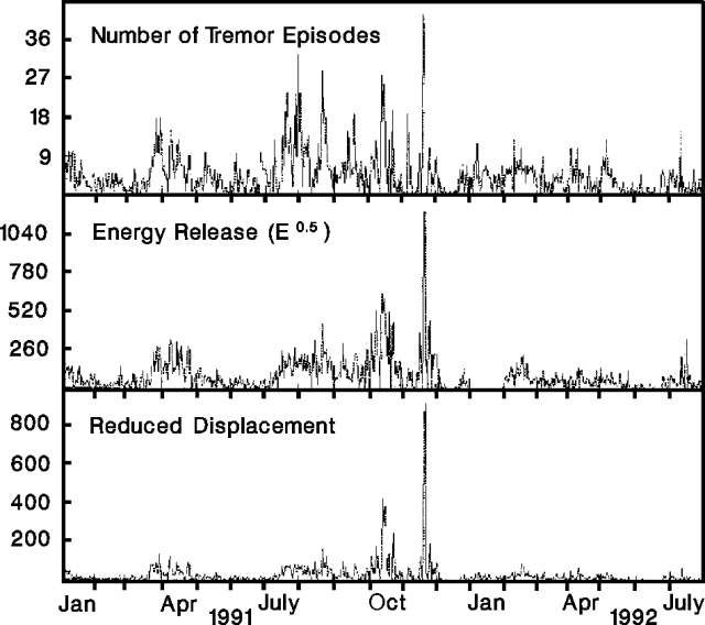 |
Figure 57. Daily number (top), energy release (middle), and reduced displacement (bottom) of tremor pulses at Galeras, January 1991-July 1992. Courtesy of INGEOMINAS. |
Fumarole temperatures reached 738°C in September 1990 and January 1991. Incandescence at vents was associated with an increase in gas emission and magmatic intrusion in June 1991. Long-period seismicity and tremor increased in July, coinciding with a strong increase in deformation rates measured by electronic tiltmeters near the crater (figure 58). Magma rose toward the surface, emerging as a dome in the bottom of the crater in October and November.
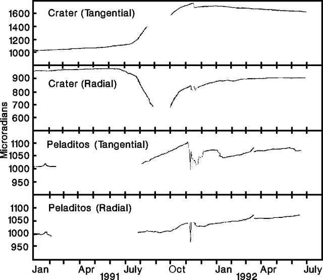 |
Figure 58. Deformation measured at electronic tiltmeters (Crater and Peladitos) 0.9 NE and 1.5 SE, respectively, of the crater at Galeras, January 1991-July 1992. Courtesy of INGEOMINAS. |
Seismicity was generally declining at the beginning of December 1991 with the exception of minor high-frequency activity. Electronic tiltmeters were stable, and gas emissions became less frequent with less ash content. Some tremor signals with durations of 18-33 minutes and dominant periods of 1 and 0.2 seconds were recorded in April and May 1992. These signals were analogous to those in the second half of 1991, associated with dome formation.
Seismicity and deformation, early July 1992. Long-period seismicity decreased gradually as the number of tremor pulses increased during the first 15 days of July. A moderate number of high-energy tremor pulses occurred 11-12 July. Six monochromatic long-period (1.54 Hz) events lasting about 80 seconds were recorded 14-16 July. On 15 July, a small swarm of ~18 high-frequency earthquakes had magnitudes of up to 0.5. Deformation rates were low (~1 µrad/day) compared to those of October and December 1991. Cumulative deformation was ~5 µrad, occurring as successive waves at the tiltmeter (Crater) 0.9 km E of the crater.
16 July explosion. The explosion at 1640 on 16 July destroyed >90% of the dome at the bottom of the crater. Fragments of various sizes were ejected ballistically. Blocks 30-40 cm in diameter fell as much as 2.3 km away; some to 1 m in diameter reached 1.3 km distance, falling on a road where they made impact craters 3 m across and 1 m deep; fragments 3.5 m across were found 400 m from the crater rim; and on the E edge of the caldera, 169 projectiles were counted in an area ~10 m wide and 1,000 m long. Incandescent blocks started forest fires on the NE flank, 2.3 km from the crater.
The dark-gray eruption column with turbulent, cauliflower-like edges rose ~4 km. Ash was dispersed mainly to the W and had a calculated minimum volume of 5.7 x 10⁴ m3. Blocks, with a minimum volume of 2.2 x 10⁴ m3, were concentrated toward the E and NE. The temperatures of block surfaces were ~290°C, and of the pyroclastic deposits around the crater, ~230°C.
Seismographs registered a 6-minute signal that began at 1640:32, saturating instruments for the initial 37 seconds. Two distinct elements were noted. The first had a frequency of 0.5 Hz and a duration magnitude of 3, and the second was a 1.3 Hz tremor event that lasted 4 minutes.
A strong accompanying explosive sound was heard at 5.5 km distance (in Genoy), and in parts of Pasto 9 km away. A relatively weak expansion wave broke some glass 9 km away, in the corregimiento (magistracy) of Nariño.
Geological Summary. Galeras, a stratovolcano with a large breached caldera located immediately west of the city of Pasto, is one of Colombia's most frequently active volcanoes. The dominantly andesitic complex has been active for more than 1 million years, and two major caldera collapse eruptions took place during the late Pleistocene. Long-term extensive hydrothermal alteration has contributed to large-scale edifice collapse on at least three occasions, producing debris avalanches that swept to the west and left a large open caldera inside which the modern cone has been constructed. Major explosive eruptions since the mid-Holocene have produced widespread tephra deposits and pyroclastic flows that swept all but the southern flanks. A central cone slightly lower than the caldera rim has been the site of numerous small-to-moderate eruptions since the time of the Spanish conquistadors.
Information Contacts: J. Romero, INGEOMINAS-Observatorio Vulcanológico del Sur.