Report on Mayon (Philippines) — February 1993

Bulletin of the Global Volcanism Network, vol. 18, no. 2 (February 1993)
Managing Editor: Edward Venzke.
Mayon (Philippines) Eruption continues; pyroclastic flows; lava extrusion
Please cite this report as:
Global Volcanism Program, 1993. Report on Mayon (Philippines) (Venzke, E., ed.). Bulletin of the Global Volcanism Network, 18:2. Smithsonian Institution. https://doi.org/10.5479/si.GVP.BGVN199302-273030
Mayon
Philippines
13.257°N, 123.685°E; summit elev. 2462 m
All times are local (unless otherwise noted)
Eruptive activity ... continued following the 2 February eruption that killed at least 70 people (18:1). The pyroclastic flow associated with that event traveled 6 km SSE down the Bonga Gully and covered approximately 4 km2 (figure 5). The total volume of the flow, roughly 1-2 x 10⁶ m3, is much less than that of the 1984 pyroclastic flows (30 x 106 m3). As much as half of the volume of the 2 February flow may have been pre-1993 rock that was scoured from the gully as the flow descended. Calculations based on eyewitness accounts suggest an early speed for the flow of >120 km/hour. Up to 5 mm of ash fell 9 km SW of the volcano.
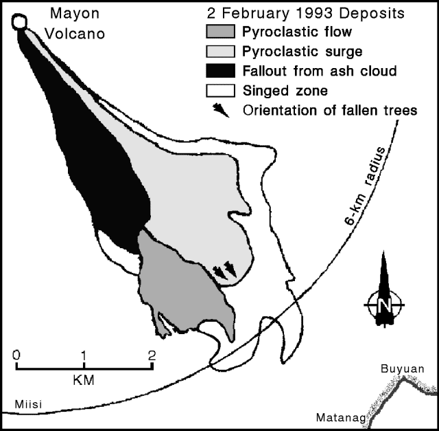 |
Figure 5. Sketch map showing the extent of the 2 February 1993 pyroclastic deposits. Courtesy of PHIVOLCS. |
Between 2 February and 19 March, activity consisted principally of slow lava extrusion, occasional ash puffs (100-500 m high), explosions (figure 6), and small pyroclastic flows generated by the collapse of lava deposits on the steep-sloped summit (table 2). Triggered by explosions or gravity, the collapses resulted in incandescent blocks rolling down the Bonga Gully. When a larger block (103-105 m3) spalled or slumped from the front of the slowly advancing lava flow, it formed a small collapse-type pyroclastic flow that traveled as far as 4 km. Ash columns from the pyroclastic flows rose as high as 1 km above the crater unless strong winds sheared them off at a lower elevation. Such flows occurred on 12-13 February, 28 February-3 March, 10 March, and 15-17 March. On 15 March the number of explosion-type seismic signals increased and a new lava flow was observed at the summit.
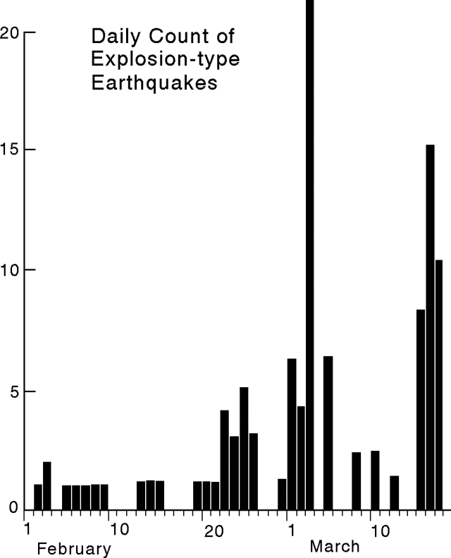 |
Figure 6. Explosion-type earthquake count recorded at Mayon, 1 February to 18 March 1993. Courtesy of PHIVOLCS. |
Table 2. Significant events at Mayon, 6 February-19 March 1993. Courtesy of PHIVOLCS.
| Date | Time | Event |
| 06 Feb 1993 | 0425 | Collapse-type pyroclastic flow travels 3 km. |
| 10-11 Feb 1993 | -- | Intermittent lava extrusion and formation of 200-m-long lava deposit. |
| 12 Feb 1993 | 1126 | Explosion generates a 1.5-km-high ash column. Collapse-type pyroclastic flow travels 3 km. |
| 12 Feb 1993 | 1230 | Explosion generates 3-km-high ash column. Collapse-type pyroclastic flow travels 3 km. |
| 12 Feb 1993 | 1509 | Ash ejection to 1 km. |
| 12 Feb 1993 | 1512 | Ash ejection 1.5 km high; cauliflower-shaped cloud. |
| 12 Feb 1993 | 2100 | Intermittent lava extrusion. |
| 13 Feb 1993 | 0445 | Explosion generates a cauliflower-shaped cloud 1 km high. Collapse-type pyroclastic flow travels 3.5 km. |
| 17-28 Feb 1993 | -- | Intermittent, slow lava extrusion; formation of 200-m-long lava flow. |
| 01 Mar 1993 | 0659 | Collapse-type pyroclastic flow travels 2.5 km. |
| 03 Mar 1993 | 1530 | Explosion-generated 1-km-high ash column. Collapse-type pyroclastic flow travels 4 km. |
| 10 Mar 1993 | 0344 | Collapse-type pyroclastic flow travels 1.5 km. |
| 15 Mar 1993 | 0140 | Start of lava extrusion. |
| 15 Mar 1993 | 2130 | Collapse-type pyroclastic flow travels 1.5 km. |
| 15 Mar 1993 | 2258 | Collapse-type pyroclastic flow travels 1.5 km. |
| 15 Mar 1993 | 2332 | Collapse-type pyroclastic flow travels 2 km. |
| 16 Mar 1993 | 2303 | Collapse-type pyroclastic flow travels 4 km. |
| 17-19 Mar 1993 | -- | Significant increase in the rate of lava extrusion at the summit. Collapse of lava becomes more frequent and produces numerous small collapse-type pyroclastic flows that travel 2-3 km. |
COSPEC measurements of SO2 began on 3 February (figure 7). Temporary decreases to 200-400 t/d on 12-13 February and 28 February were followed by small collapse-type pyroclastic flows. Most measurements after 7 March were ground-based instead of air-based. The ground-based measurements may not record all the SO2 that air-based measurements record because no available roads allow complete, rapid circumnavigation of Mayon. On 10 March, however, the two techniques were cross-checked and their values agreed.
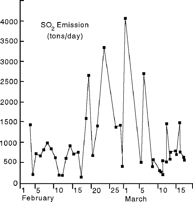 |
Figure 7. COSPEC measurements of SO2 emission at Mayon, 31 January-18 March, 1993. Courtesy of PHIVOLCS |
During the last half of February, moderate to heavy rains on the SE flank remobilized the new pyroclastic deposits and generated small lahars. All lahars remained essentially confined to the channels.
There were numerous reports of a 2-3 m drop of the water table in the vicinity of Mayon in late 1992 and January 1993 as evidenced by water wells drying or decreasing production. Local observers also stated that similar drops occurred before the 1968, 1978, and 1984 eruptions, but that those drops were not as pronounced as the current one. A climber observed an increase in rockfalls and deepening of the Bonga Gully 6 days before the 2 February eruption but did not report his observations until after the eruption. Just prior to the 1984 eruption of Mayon he had reported a bulging of the normally concave crater floor into a convex dome. A PHIVOLCS observer reported that the temperature of a crater fumarole increased from 97°C in May 1991 to 150°C in July 1992.
Stephen O'Meara observed Mayon from 27 February to 7 March and reported the following.
Three N-S-trending vents or fissures in the summit crater were visible from the ruins near the village of Cagsaua (10 km SE of the summit) on 27 and 28 February. The N vent (also the highest) was the most active. At times the vents were clearly visible; at other times the entire throat of the summit crater was filled with a large, white, cauliflower-shaped cloud that did not rise above the crater. The steam cloud appeared to contain ash on 28 February.
Winds on the morning of 1 March blew the steam plume to Legazpi City, 14 km SE of the summit. It contained a dark gray tinge and smelled of sulfur. At 0700 a slow, silent pyroclastic flow traveled down the Bonga Gully. Simultaneously, a smaller flow moved S down the Miisi Gully. The gray cloud from the Bonga flow appeared to be composed of many segments produced by frequent bursts, but this may have been an illusion caused by strong winds. Ash fell on the S flank of the volcano.
At Arimbay (approximately 2.5 km N of Legazpi City), the smell of sulfur was noticed about 5 minutes prior to the arrival of a lahar at 1530 on 3 March. The knee-deep lahar was warm but not boiling. Approximately 1.5 m of mud, stones, and boulders deposited by previous lahars blocked traffic on the Legazpi-Tabaco road in Arimbay. Also on 3 March, a pyroclastic flow, larger and darker than the one seen on 1 March, "casually" rolled down the Bonga Gully.
On 4 March a reddish brown ash cloud traveled down the Bonga Gully, but did not develop into a strong pyroclastic flow. The cloud remained confined to the upper half of the gully. At 0100 on 5 March a faint crater glow was noticed with just a "spark" coming from the N vent. One small gray ash puff occurred between 0530 and 0730 and was confined to the crater. A reddish-brown ash puff seen in the afternoon also remained in the crater. Crater glow was observed before sunrise on 6 March and a reddish-brown ash puff similar to that observed on 5 March occurred in the early morning. At approximately 0800 on 7 March a larger, darker, gray ash eruption lasted 5 minutes. Nothing traveled down the Bonga, but a tiny pyroclastic flow may have traveled S down the Miisi Gully.
Geological Summary. Symmetrical Mayon, which rises above the Albay Gulf NW of Legazpi City, is the most active volcano of the Philippines. The steep upper slopes are capped by a small summit crater. Recorded eruptions since 1616 CE range from Strombolian to basaltic Plinian, with cyclical activity beginning with basaltic eruptions, followed by longer term andesitic lava flows. Eruptions occur predominately from the central conduit and have also produced lava flows that travel far down the flanks. Pyroclastic flows and mudflows have commonly swept down many of the approximately 40 ravines that radiate from the summit and have often damaged populated lowland areas. A violent eruption in 1814 killed more than 1,200 people and devastated several towns.
Information Contacts: PHIVOLCS; S. O'Meara, Sky & Telescope, Belmont, MA; Chris Newhall, USGS.