Report on Krakatau (Indonesia) — May 1993

Bulletin of the Global Volcanism Network, vol. 18, no. 5 (May 1993)
Managing Editor: Edward Venzke.
Krakatau (Indonesia) New lava flows; one person killed
Please cite this report as:
Global Volcanism Program, 1993. Report on Krakatau (Indonesia) (Venzke, E., ed.). Bulletin of the Global Volcanism Network, 18:5. Smithsonian Institution. https://doi.org/10.5479/si.GVP.BGVN199305-262000
Krakatau
Indonesia
6.1009°S, 105.4233°E; summit elev. 285 m
All times are local (unless otherwise noted)
Activity has continued . . . since . . . 7 November 1992. A mid-November lava flow reached the NW coast and entered the ocean (figure 5). This lava flow continued to advance until early February. Beginning in February, a new lava flow traveled SSE, destroying seismic stations maintained by VSI and Gadjah Mada Univ (GMU). Another lava flow descended to the N in April, overflowed the old crater rim in May, and burned a forested area near the coast. Analyses of the April 1993 lavas showed 53.5% SiO2, an increase from the November 1992 lavas (51.3%).
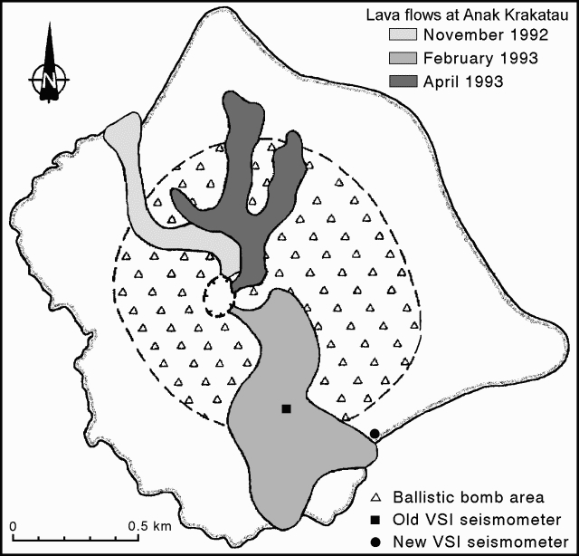 |
Figure 5. Sketch map of Anak Krakatau showing recent lava flows (November 1992-April 1993), VSI seismometer locations, and ballistic bomb area. Courtesy of VSI. |
Scientists from GMU reported degassing events and lava-block ejections on 6 May. Sharp thunder-claps were also heard, and ash fell heavily during most of their 8-hour visit. As of 13 June, the most recent activity observed by VSI geologists was a vertical Vulcanian explosion with a column ~150 m in diameter and 200-600 m high. There was no evidence of pyroclastic flows. Tephra deposits have built a new cone to at least 280 m asl, much higher than the previous peak (199 m elevation). A moderate explosion on 13 June killed one tourist and injured five others climbing on the old crater rim. Since the eruption began, tourists have been advised by VSI and the local government to remain at least 3 km from the island.
A new vertical seismometer was installed by VSI on 17 April ~10 m from the coast and 15 m asl on the SE side of the island (figure 5). Data are telemetered to the volcano observatory in Pasauran . . . . From 18 April to 7 May there were 4 days with >1,500 explosions and another 7 days with >1,000 (figure 6). Seismically detected explosions then gradually declined into early June. The number of explosion earthquakes/day was generally lower during this period than in late 1992 and early 1993.
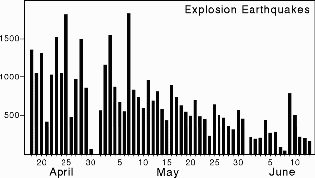 |
Figure 6. Number of daily explosion earthquakes at Anak Krakatau, 18 April to 13 June 1993. Courtesy of VSI. |
GMU placed a new seismic station on the E side of the outer crater rim on 6 May. Long-period and short-period 3-component measurements were also carried out during the visit to the island. Approximately events were detected during 6 hours of long-period seismic measurements (cutoff frequency 0.2 Hz). About 80% of these events could be correlated with visual observations of activity. Felt or observed earthquakes occurred an average of every 4 minutes, with stronger events every 7-8 minutes. Analysis indicates that the non-correlated seismic events had deeper hypocenters.
Geological Summary. The renowned Krakatau (frequently mis-named as Krakatoa) volcano lies in the Sunda Strait between Java and Sumatra. Collapse of an older edifice, perhaps in 416 or 535 CE, formed a 7-km-wide caldera. Remnants of that volcano are preserved in Verlaten and Lang Islands; subsequently the Rakata, Danan, and Perbuwatan cones were formed, coalescing to create the pre-1883 Krakatau Island. Caldera collapse during the catastrophic 1883 eruption destroyed Danan and Perbuwatan, and left only a remnant of Rakata. This eruption caused more than 36,000 fatalities, most as a result of tsunamis that swept the adjacent coastlines of Sumatra and Java. Pyroclastic surges traveled 40 km across the Sunda Strait and reached the Sumatra coast. After a quiescence of less than a half century, the post-collapse cone of Anak Krakatau (Child of Krakatau) was constructed within the 1883 caldera at a point between the former Danan and Perbuwatan cones. Anak Krakatau has been the site of frequent eruptions since 1927.
Information Contacts: W. Tjetjep, VSI; K. Brotopuspito, GMU.