Report on Galeras (Colombia) — June 1993

Bulletin of the Global Volcanism Network, vol. 18, no. 6 (June 1993)
Managing Editor: Edward Venzke.
Galeras (Colombia) Eruption on 7 June ejects >1.2 million cubic meters of material
Please cite this report as:
Global Volcanism Program, 1993. Report on Galeras (Colombia) (Venzke, E., ed.). Bulletin of the Global Volcanism Network, 18:6. Smithsonian Institution. https://doi.org/10.5479/si.GVP.BGVN199306-351080
Galeras
Colombia
1.22°N, 77.37°W; summit elev. 4276 m
All times are local (unless otherwise noted)
A pyroclastic eruption that began at 0342 on 7 June was the fifth eruption of 1993 and ejected the largest amount of material (18:5). A dense eruptive column formed rapidly and rose 7 km above the crater rim, with a halo of incandescence at the base that extended 1 km up the column. Lightning was caused by ionization of the atmosphere, and military personnel within 4 km of the crater reported jet-like sounds at the start of activity. This eruption was registered by the seismic network for a total of 18 minutes, with 26 seconds of small-amplitude tremor followed by 2 minutes of long-period seismicity, and then 15 minutes of spasmodic tremor. There were 354 long-period earthquakes registered in the 17 hours after the initial eruption; these gradually decreased in size and number during the last 7 hours. Overflights after the initial eruption (0700 and 1715) revealed no substantive changes in crater morphology, although fresh deposits of ash and other pyroclastic materials were observed. Gas emission was concentrated on the W side of the crater and on the upper part of the active cone. A second eruptive phase began at 2137, with tremor lasting 93 minutes. Pulses of emissions produced a low-altitude eruptive column with incandescence and lightning. No deformation related to the eruptions was detected by electronic tiltmeters on the upper parts of the volcano. SO2 had returned to low levels the day after the eruptions.
The initial eruption was directed N38°E. Ballistic projectiles with diameters <=30 cm were found up to 1 km from the active cone and fragments <=50 cm in diameter were found up to 500 m away. Lapilli <15 mm in diameter were observed up to 6 km NE of the crater (figure 68). Ash was distributed by the wind to the N, reaching a maximum thickness no greater than 5 mm. Finer material was blown up to 110 km away, covering an area of ~5,000 km2 (figure 69). An estimated 0.65 x 10⁵ m3 of ballistic projectiles and 11.9 x 10⁵ m3 of ash was distributed by the wind. The total of 12.6 x 10⁵ m3 is the greatest volume of material ejected in the current active period (figure 70).
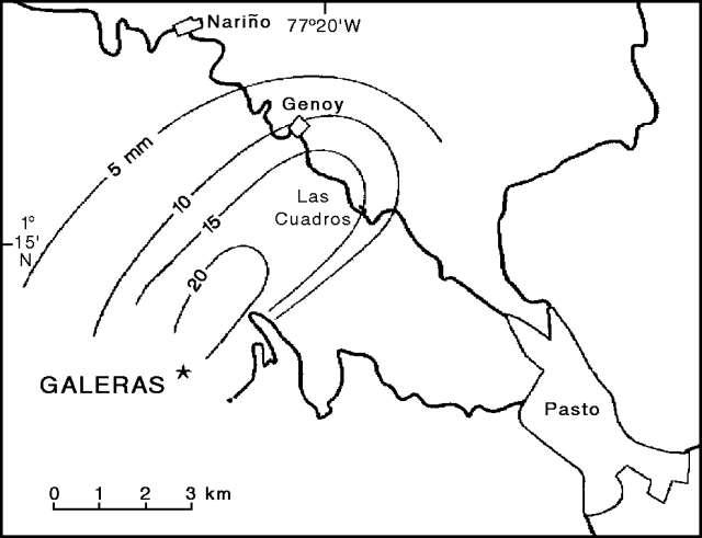 |
Figure 68. Isopleth map of lithic fragment distribution from the 7 June 1993 Galeras eruption. Isopleth values are in millimeters. Several roads leading to Pasto are indicated. Courtesy of INGEOMINAS. |
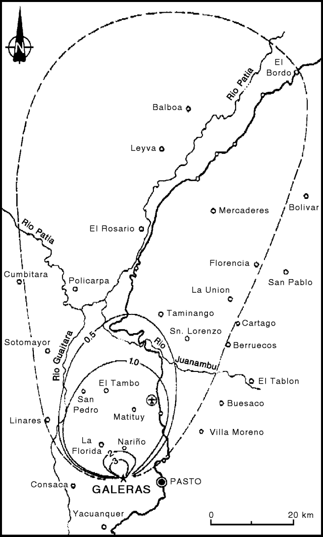 |
Figure 69. Isopach map of ash emitted during the 7 June 1993 Galeras eruption. Isopach values are in millimeters; dashed line indicates the approximate limit of fine ash distribution. Location of airport shown by airplane symbol in circle. Courtesy of INGEOMINAS. |
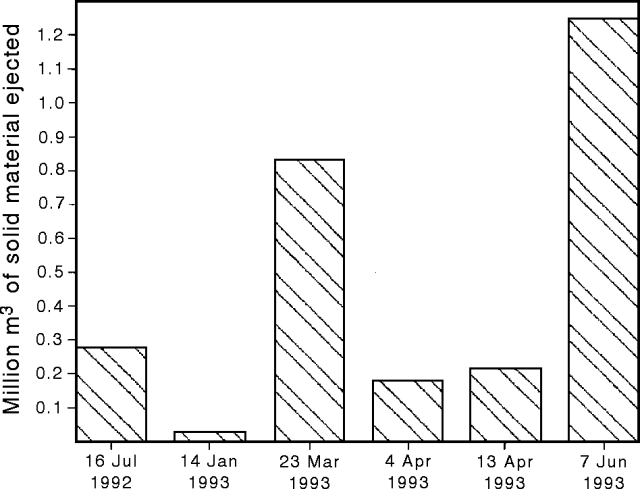 |
Figure 70. Comparison of volume of material ejected by recent eruptions at Galeras, July 1992 to June 1993. Courtesy of INGEOMINAS. |
Except for the interval immediately following the 7 June eruption, both long-period and high-frequency seismicity were generally low in June. Between 18 April and 7 June, 104 long-period tornillos ("screw-type" seismic events) were registered; the last was 3 hours before the eruption. Hybrid events (between high-frequency and long-period) named "butterfly-type" events, were detected 4-7 June. These were located around the W side of the active crater at depths <1 km and had magnitudes <1.8.
Geological Summary. Galeras, a stratovolcano with a large breached caldera located immediately west of the city of Pasto, is one of Colombia's most frequently active volcanoes. The dominantly andesitic complex has been active for more than 1 million years, and two major caldera collapse eruptions took place during the late Pleistocene. Long-term extensive hydrothermal alteration has contributed to large-scale edifice collapse on at least three occasions, producing debris avalanches that swept to the west and left a large open caldera inside which the modern cone has been constructed. Major explosive eruptions since the mid-Holocene have produced widespread tephra deposits and pyroclastic flows that swept all but the southern flanks. A central cone slightly lower than the caldera rim has been the site of numerous small-to-moderate eruptions since the time of the Spanish conquistadors.
Information Contacts: M. Calvache, INGEOMINAS, Pasto.