Report on Krakatau (Indonesia) — July 1993

Bulletin of the Global Volcanism Network, vol. 18, no. 7 (July 1993)
Managing Editor: Edward Venzke.
Krakatau (Indonesia) Explosions continue; bombs destroy another seismometer
Please cite this report as:
Global Volcanism Program, 1993. Report on Krakatau (Indonesia) (Venzke, E., ed.). Bulletin of the Global Volcanism Network, 18:7. Smithsonian Institution. https://doi.org/10.5479/si.GVP.BGVN199307-262000
Krakatau
Indonesia
6.1009°S, 105.4233°E; summit elev. 285 m
All times are local (unless otherwise noted)
Anak Krakatau has now been in continuous eruption for nine months . . . . Continued explosions (140-400/day) have built a new cone to ~280-300 m elev, which is 80-100 m above the old peak (figure 7). A seismometer installed by VSI was destroyed by a ballistic bomb on 16 July; lava flows have previously destroyed two other seismometers. Earlier this year, lava flows filled the valley between the cone and the old rim, and overflowed onto the outer slope of the old rim. The April 1993 lava flow descended the N flank to the coast, where it burned trees. The recommended off-limits zone, 3 km from the island, remains in effect.
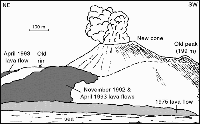 |
Figure 7. Sketch of Anak Krakatau showing topographical changes, as of July 1993, since the eruption began in Nov 1992. View is looking SE; scale is approximate. Drawn by Igan S. Sutawidjaja; courtesy of VSI. |
Geological Summary. The renowned Krakatau (frequently mis-named as Krakatoa) volcano lies in the Sunda Strait between Java and Sumatra. Collapse of an older edifice, perhaps in 416 or 535 CE, formed a 7-km-wide caldera. Remnants of that volcano are preserved in Verlaten and Lang Islands; subsequently the Rakata, Danan, and Perbuwatan cones were formed, coalescing to create the pre-1883 Krakatau Island. Caldera collapse during the catastrophic 1883 eruption destroyed Danan and Perbuwatan, and left only a remnant of Rakata. This eruption caused more than 36,000 fatalities, most as a result of tsunamis that swept the adjacent coastlines of Sumatra and Java. Pyroclastic surges traveled 40 km across the Sunda Strait and reached the Sumatra coast. After a quiescence of less than a half century, the post-collapse cone of Anak Krakatau (Child of Krakatau) was constructed within the 1883 caldera at a point between the former Danan and Perbuwatan cones. Anak Krakatau has been the site of frequent eruptions since 1927.
Information Contacts: W. Tjetjep, VSI.