Report on Kilauea (United States) — August 1993

Bulletin of the Global Volcanism Network, vol. 18, no. 8 (August 1993)
Managing Editor: Edward Venzke.
Kilauea (United States) Lava enters ocean along both sides of the Kamoamoa delta
Please cite this report as:
Global Volcanism Program, 1993. Report on Kilauea (United States) (Venzke, E., ed.). Bulletin of the Global Volcanism Network, 18:8. Smithsonian Institution. https://doi.org/10.5479/si.GVP.BGVN199308-332010
Kilauea
United States
19.421°N, 155.287°W; summit elev. 1222 m
All times are local (unless otherwise noted)
The . . . eruption continued throughout August as lava entered the ocean on the E and W sides of the Kamoamoa delta . . . . Early in the month the W lava flow had several breakouts active along its length and several littoral explosions were observed at the ocean entries. The E branch of this flow also fed lava into the ocean but at a lesser volume. On 8 August, large flows broke out of the tube system between 420 and 480 m elevation. One large flow from the lower breakout advanced down over a fault scarp and covered new land and ancient Hawaiian ruins on the E side of the flow field. By 10 August, this channelized aa and pahoehoe flow cascaded over another fault scarp and ponded at its base. The flow continued to advance along the E margin of the Kamoamoa flow and soon entered the ocean on the E side of the delta (figure 93). This new flow fed lava into the ocean through 21 August and as activity on the E side of the delta declined, most of the erupted material continued to feed directly to the ocean on the W side of the Kamoamoa delta. Vigorous littoral explosions were observed at the ocean entries.
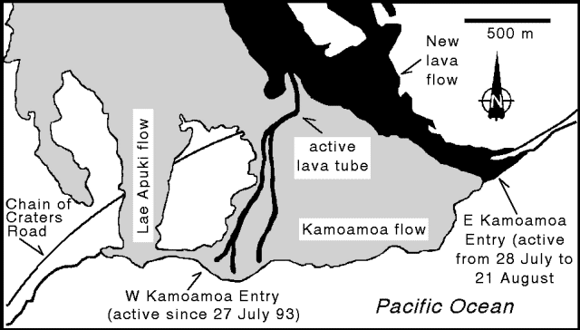 |
Figure 93. Recent lava flows from Kīlauea in the Kamoamoa delta area, August 1993. Lava entered the ocean fed by the flow that broke out of the Kamoamoa tube at the end of July. The E lava flow was active until 21 August while the W entry continued to be active as of this writing. Courtesy of T. Mattox. |
On 21 August, a 277 m-long sliver of land separated from the W side of the Kamoamoa delta along a 1-2 m-wide crack. The crack exposed lava tubes, some filled with lava and others empty and glowing. The sliver of land was 2-3 m below the level of the main Kamoamoa delta. On the evening of 23 August, water entered this active tube system, generating large jets of steam, tephra, and large radial spatter explosions. A ground survey of the area revealed large fields of lithic debris and spatter behind the W Kamoamoa entry.
Eruption tremor along the East rift zone was relatively stable in August at 2x background level. Shallow, long-period microearthquake counts were high during the first half of the month, ranging from 169 to slightly over 300 per day. Return to average long-period activity levels was as abrupt as the onset of the high counts. During the last half of the month, shallow long-period events were moderate in number except during 22-26 August when > 800 long-period events originating from intermediate depths were recorded. Counts for shallow short-period events were low beneath the summit and about average along the East rift zone. On 21 August, a large explosive event registered on East rift seismic stations, coincident with coastal bench collapse.
Geological Summary. Kilauea overlaps the E flank of the massive Mauna Loa shield volcano in the island of Hawaii. Eruptions are prominent in Polynesian legends; written documentation since 1820 records frequent summit and flank lava flow eruptions interspersed with periods of long-term lava lake activity at Halemaumau crater in the summit caldera until 1924. The 3 x 5 km caldera was formed in several stages about 1,500 years ago and during the 18th century; eruptions have also originated from the lengthy East and Southwest rift zones, which extend to the ocean in both directions. About 90% of the surface of the basaltic shield volcano is formed of lava flows less than about 1,100 years old; 70% of the surface is younger than 600 years. The long-term eruption from the East rift zone between 1983 and 2018 produced lava flows covering more than 100 km2, destroyed hundreds of houses, and added new coastline.
Information Contacts: T. Mattox, HVO.