Report on Krakatau (Indonesia) — October 1993

Bulletin of the Global Volcanism Network, vol. 18, no. 10 (October 1993)
Managing Editor: Edward Venzke.
Krakatau (Indonesia) Details of seismicity in mid-August
Please cite this report as:
Global Volcanism Program, 1993. Report on Krakatau (Indonesia) (Venzke, E., ed.). Bulletin of the Global Volcanism Network, 18:10. Smithsonian Institution. https://doi.org/10.5479/si.GVP.BGVN199310-262000
Krakatau
Indonesia
6.1009°S, 105.4233°E; summit elev. 285 m
All times are local (unless otherwise noted)
In mid-August GMU scientists repaired damaged seismic equipment and conducted a seismic study on Anak Krakatau. GMU's seismic station was damaged by volcanic bombs on 18 May, only 12 days after installation. The new station consists of a 1-Hz vertical-component seismometer on the E flank of the island, closer to the coast and farther from the source vent than the damaged station (figure 5).
On 14 August the GMU team also deployed a 3-component seismograph with a 0.2 Hz cutoff frequency and collected data from 0900 to 1700. During this 8-hour interval >100 events were registered, with >90% correlated with minor explosions seen at the surface. In contrast to the bulk of the events, which had shallow sources, the events without visual correlation caused particle motions implying generation at greater depth . . . . Volcanically quiet intervals indicated little seismic contribution from ocean waves; such waves were chiefly of low amplitude and confined to the 0.5-3 Hz frequency range.
About four hours of the vertical-component seismic record are shown on figure 8. Many events appeared at 3-minute intervals. Longer intervals of quiet also occurred, and typically terminated in strong seismic shocks and eruptions. A more detailed 3-component record of a comparatively large event on 14 August (figure 9) shows relative quiet prior to the event, and near 0.2, 0.5, and 1.1 minutes, peaks in the seismic signal. The lower portion of figure 9 shows the computed smoothed spectra (from maximum entropy spectral analysis) for the three components.
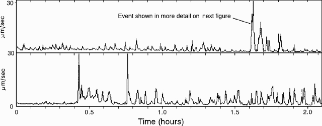 |
Figure 8. Anak Krakatau vertical-component seismic records for two 2-hour intervals on 14 August 1993: beginning at 0859 (top), and beginning at 1105 (bottom). Courtesy of A. Brodscholl and K. Brotopuspito. |
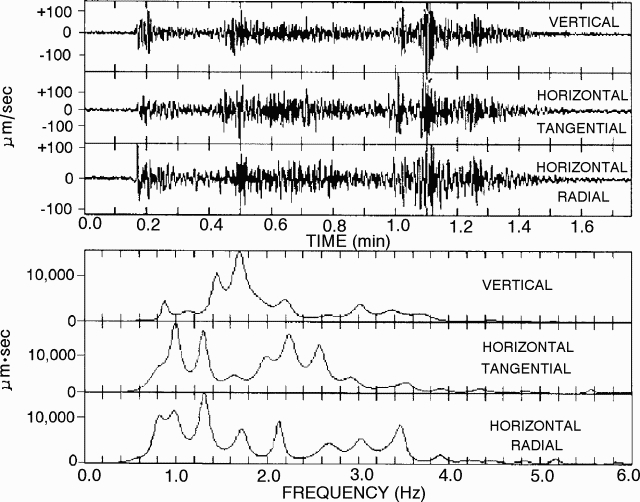 |
Figure 9. Anak Krakatau 3-component seismic record (top), and associated smoothed spectra for the event marked on figure 8 (bottom). Courtesy of A. Brodscholl and K. Brotopuspito. |
During installation of the new system, scientists witnessed degassing and ejection of silica-rich volcanic bombs. They found no pumice. Observers on [Carita Beach] noted that lava glowed strongly in early May but had stopped by mid-June. As of 14 August glowing had not reappeared. [News reports during the 1994 eruption indicated that activity ceased in October 1993.]
Geological Summary. The renowned Krakatau (frequently mis-named as Krakatoa) volcano lies in the Sunda Strait between Java and Sumatra. Collapse of an older edifice, perhaps in 416 or 535 CE, formed a 7-km-wide caldera. Remnants of that volcano are preserved in Verlaten and Lang Islands; subsequently the Rakata, Danan, and Perbuwatan cones were formed, coalescing to create the pre-1883 Krakatau Island. Caldera collapse during the catastrophic 1883 eruption destroyed Danan and Perbuwatan, and left only a remnant of Rakata. This eruption caused more than 36,000 fatalities, most as a result of tsunamis that swept the adjacent coastlines of Sumatra and Java. Pyroclastic surges traveled 40 km across the Sunda Strait and reached the Sumatra coast. After a quiescence of less than a half century, the post-collapse cone of Anak Krakatau (Child of Krakatau) was constructed within the 1883 caldera at a point between the former Danan and Perbuwatan cones. Anak Krakatau has been the site of frequent eruptions since 1927.
Information Contacts: A. Brodscholl and K. Brotopuspito, GMU.