Report on Pagan (United States) — February 1994
Bulletin of the Global Volcanism Network, vol. 19, no. 2 (February 1994)
Managing Editor: Richard Wunderman.
Pagan (United States) Increased ash output in 1993 from small eruptions
Please cite this report as:
Global Volcanism Program, 1994. Report on Pagan (United States) (Wunderman, R., ed.). Bulletin of the Global Volcanism Network, 19:2. Smithsonian Institution. https://doi.org/10.5479/si.GVP.BGVN199402-284170
Pagan
United States
18.13°N, 145.8°E; summit elev. 570 m
All times are local (unless otherwise noted)
Pagan's behavior has been the subject of a recent study addressing local and regional seismicity, instrumentation, eruption dynamics, and a means of possibly increasing the safety of visiting the island (Koyanagi and others, 1993). The study reached the following conclusions: 1) Pagan exhibited an active "open vent" state (with obvious hazard implications), 2) Ash eruptions, which occur frequently at Pagan, were revealed seismically by volcanic tremor, and 3) Tremor amplitude and duration appeared roughly proportional to the height and duration of the ash eruption.
The Pagan seismograph (PAGV, figure 3) is installed in a thick, concrete World War II bunker that helps absorb noise. Its signal is radio-relayed sequentially with those from three other stations to the Emergency Operation Center in Saipan (305 km S) for continuous recording. The system has operated since July 1992.
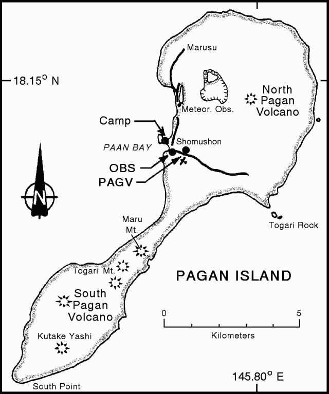 |
Figure 3. Map of Pagan Island showing the locations of volcanic cones and the permanent seismometer (PAGV). Observations on 14-17 November 1993 were also made from the site of the portable seismometer near the airstrip (OBS) and the campsite (Camp). On the original map North Pagan was labeled Mt. Pagan (Koyanagi and others, 1993). |
In the latter half of 1992 low-frequency earthquakes dominated; these events indicated internal instability of the volcano without surface eruptions. In late 1992 and early 1993, longer bursts of tremor sustained for 5 minutes to more than an hour became increasingly common.
On 18 January 1993 a moderate M 5.7 earthquake occurred deep beneath the Pagan area. During the subsequent months (first half of 1993), 30-60-minute bursts of tremor persisted at semi-regular intervals, alternating with low-amplitude tremor lasting several hours. The bursts occasionally reached amplitudes of 20x background; during a few bursts visitors reported moderate ash eruptions. This type of tremor is sometimes called banded tremor. The name comes from the alternating pattern of high and low amplitudes written on a revolving-drum seismograph (figure 4).
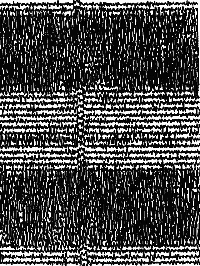 |
Figure 4. Seismogram of banded tremor associated with intermittent Pagan ash emissions. Recorded on station PAGV, 12 June 1993; no scale indicated (after Koyanagi and others, 1993). |
In the interval June-August 1993 tremor level decreased to occasional bursts of long-period events; also, high background signals were caused by heavy surf and stormy sea conditions. Since mid-1993 there have been short bursts of tremor <30 minutes in duration at variable intervals and with amplitudes <10x background. Given the absence of microearthquakes this tremor activity suggests continued minor volcanic activity.
A campsite was established 14-17 November 1993 (figure 3). Observations were made from the campsite and from the W end of the airstrip where a portable seismograph was operated. The visiting team included the principal observers and instrument specialists, George Kojima (USGS), Ramon Chong (CNMI), and Robert Koyanagi (USGS), with logistical support from four other members of the CNMI Office of Disaster Control.
In the first two days, researchers frequently observed seismic tremor with amplitudes of 5-10 mm lasting from 5 minutes to >30 minutes. In the next two days, amplitudes and number of episodes decreased. Figure 5 shows one typical example of tremor and associated ash eruptions (taken on 16 November). Koyanagi and others (1993) documented several other similar cases as well.
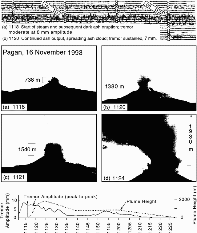 |
Figure 5. Comparison of tremor amplitude and explosive plume height for one eruptive sequence (Koyanagi and others, 1993). Registered at station PAGV during the interval 1111-1215, 16 November 1993. Top: An example of the seismic record of tremor, with notes describing the peak-to-peak amplitudes and the early stages of the eruptive sequence. Flags numbered a and b correspond to images shown below. Seismic record is not at original scale of Koyanagi and others (1993). Middle: Diagrams of the early-middle phases of a small eruption at Pagan. The diagrams were based on color photographs and illustrate the development of the plume and the associated height measurements. Diagram d represents the maximum plume height (plume bent toward viewer, top not shown). The plume heights were estimated from geometry by workers in the field. The heights shown are approximate, they were reconstructed from the plot below. Bottom: Plot showing peak-to-peak tremor amplitude and explosive plume height versus time. The arrow refers to the on-site observation of the eruption onset. |
Activity typically followed this sequence: a) Seismic tremor started, b) White volcanic gases and steam were emitted 1-3 minutes after the onset of tremor, ash came out about a minute later, c) Tremor amplitude typically peaked several minutes after tremor onset, d) The ash plume spread and rose up to 1-2 km above the summit about 5 minutes after ash outbreak, and e) Ash fell at the campsite about 10 minutes after ash outbreak. Winds were generally low during the survey, but occasional changes affected the height and configuration of the ash column and direction of ashfall.
During the observation period, tremor amplitude and duration seemed roughly proportional to the height and duration of the ash eruption. Times and amplitudes of seismic tremor were recorded using a portable revolving-drum seismograph. The seismic records were later verified with the signals telemetered to Saipan from the permanent station. Given the correlation between tremor and ash eruptions, the continuously recording seismograph provides both an indirect, unbroken documentation of the volcano's eruptive behavior, and a way to make short-term forecasts of eruptive episodes to improve the safety of visits to the island.
Reference. Koyanagi, R., Kojima, G., Chong, F., and Chong, R., 1993, Seismic monitoring of earthquakes and volcanoes in the Northern Mariana Islands: 1993 summary report: Prepared for the Office of the Governor, Commonwealth of the Northern Mariana Islands, Capitol Hill, Saipan MP 96950 (revised 21 February 1993), 34 p.
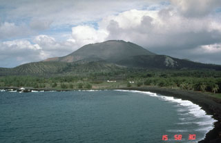
Geological Summary. Pagan Island, the largest and one of the most active of the Mariana Islands volcanoes, consists of two stratovolcanoes connected by a narrow isthmus. Both North and South Pagan stratovolcanoes were constructed within calderas, 7 and 4 km in diameter, respectively. North Pagan at the NE end of the island rises above the flat floor of the northern caldera, which may have formed less than 1,000 years ago. South Pagan is a stratovolcano with an elongated summit containing four distinct craters. Almost all of the recorded eruptions, which date back to the 17th century, have originated from North Pagan. The largest eruption during historical time took place in 1981 and prompted the evacuation of the sparsely populated island.
Information Contacts: R. Koyanagi, HVO; R. Chong, Disaster Control Office, Saipan.