Report on Nyamulagira (DR Congo) — June 1994
Bulletin of the Global Volcanism Network, vol. 19, no. 6 (June 1994)
Managing Editor: Richard Wunderman.
Nyamulagira (DR Congo) Ash emission from new vent on W flank
Please cite this report as:
Global Volcanism Program, 1994. Report on Nyamulagira (DR Congo) (Wunderman, R., ed.). Bulletin of the Global Volcanism Network, 19:6. Smithsonian Institution. https://doi.org/10.5479/si.GVP.BGVN199406-223020
Nyamulagira
DR Congo
1.408°S, 29.2°E; summit elev. 3058 m
All times are local (unless otherwise noted)
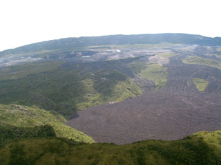
[The following was extracted from a combined Nyiragongo/Nyamuragira report.] Nyiragongo . . . is ~18 km N of Goma, the city where the major encampment of Rwandan civil-war refugees is located. Nyamuragira volcano (14 km NW of Nyiragongo) also began erupting on 4 July from W of the crater. This flank fissure eruption . . . has produced lava fountaining, lava flows, and ash emission.
On 4 July, Nyamuragira erupted "small red-hot lava flows," according to one news report. Another report on 22 July stated that the W-flank vent . . . was ejecting thick "black dust" to as high as 100 m above the vent, causing crop damage within a 35 km radius. Press reports through 24 July continued to mention volcanic "smoke" or "dust" falling in the refugee camps.
A preliminary analysis of data from the Meteor-3 TOMS for 5-10 July revealed a small area of very high SO2 over the Nyiragongo/Nyamuragira area. Individual centers of activity could not be resolved because the best ground resolution is 66 km. The SO2 cloud mass was estimated to be 100 kt on 5 July. The next day a much larger cloud extended almost 1,000 km W and had an estimated mass of 500 kt, with the highest values directly over the volcanoes. Data from 7 July were similar, but the cloud extended >1,000 km S. The SO2 cloud mass had decreased to an estimated 300 kt by 8 July and it extended diffusely SW from the volcano. Very high values directly over the volcanoes continued on 9 July, and the diffuse cloud to the W had ~250 kt SO2. By 10 July, values remained high, but were lower over the volcano; estimated SO2 cloud mass was 80 kt.
Reference. Zana, N., Kasahara, M., Kasereka, M., Azangi, M., and Wafula, M., 1993, Surface deformations and seismic activities related to the 1991-1992 Nyamuragira eruption: IAVCEI, Canberra Meeting Abstracts, p. 127.
Geological Summary. Africa's most active volcano, Nyamulagira (also known as Nyamuragira), is a massive high-potassium basaltic shield about 25 km N of Lake Kivu and 13 km NNW of the steep-sided Nyiragongo volcano. The summit is truncated by a small 2 x 2.3 km caldera that has walls up to about 100 m high. Documented eruptions have occurred within the summit caldera, as well as from the numerous flank fissures and cinder cones. A lava lake in the summit crater, active since at least 1921, drained in 1938, at the time of a major flank eruption. Recent lava flows extend down the flanks more than 30 km from the summit as far as Lake Kivu; extensive lava flows from this volcano have covered 1,500 km2 of the western branch of the East African Rift.
Information Contacts: H. Hamaguchi and M. Kasereka, Tohoku Univ; M. Akumbi, CRSN, Goma; N. Zana, Centre de Recherche en Géophysique, Kinshasa; J. Durieux, GEVA, Lyon, France; I. Sprod, GSFC; Reuters; AP; Agence France Press.

