Report on Nyamulagira (DR Congo) — July 1994

Bulletin of the Global Volcanism Network, vol. 19, no. 7 (July 1994)
Managing Editor: Richard Wunderman.
Nyamulagira (DR Congo) High lava fountains feed lava flow on NW flank
Please cite this report as:
Global Volcanism Program, 1994. Report on Nyamulagira (DR Congo) (Wunderman, R., ed.). Bulletin of the Global Volcanism Network, 19:7. Smithsonian Institution. https://doi.org/10.5479/si.GVP.BGVN199407-223020
Nyamulagira
DR Congo
1.408°S, 29.2°E; summit elev. 3058 m
All times are local (unless otherwise noted)
High lava fountaining in early July took place from a new vent on the W flank, named Kimera. Located ~100 m S of the 1971 Rugarama cone, this vent became active at 2148 on 4 July, but remained active for only 4-5 days. The lava flows generally moved W until at least 10 July, when the flows reached their maximum extent. By 11 July, the small lake (Magera) at the E foot of a Precambrian escarpment was entirely filled and dried by the flow. High SO2 concentrations detected by the TOMS during 5-10 July were most likely caused by this activity at Nyamuragira and not from the lava lake at Nyiragongo. Nyamuragira also emitted levels of SO2 detectable by satellite during 17-19 July 1986 (275-375 ± 30% kt) and on 24 September 1991 (20 kt).
A press report described falls of both ash and Pele's hair during the first half of July in the Mokoto Hills, above the W escarpment of the rift ~20 km from the volcano. Several farmers reported problems caused by cattle eating ash-laden grass.
Long-term monitoring data indicated an apparent acceleration in seismo-geodetic activity in the past 10 years. Seismicity steadily increased from
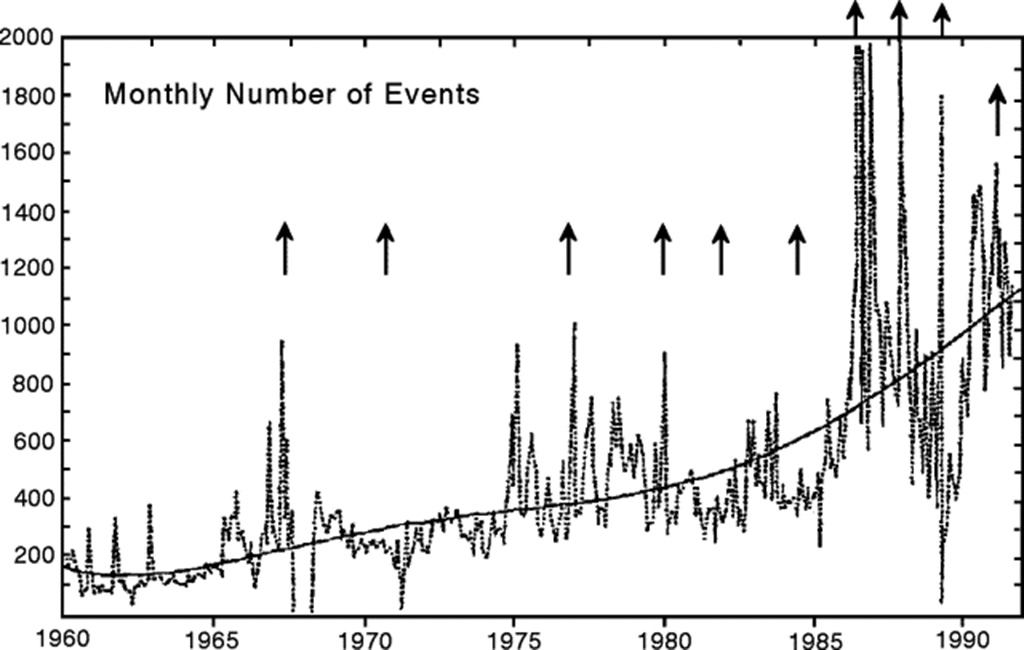 |
Figure 13. Monthly number of volcanic earthquakes at Nyamuragira, 1960-92. The short-period seismic station is located 110 km from the volcano. Vertical arrows indicate flank eruptions. Courtesy of H. Hamaguchi. |
Geological Summary. Africa's most active volcano, Nyamulagira (also known as Nyamuragira), is a massive high-potassium basaltic shield about 25 km N of Lake Kivu and 13 km NNW of the steep-sided Nyiragongo volcano. The summit is truncated by a small 2 x 2.3 km caldera that has walls up to about 100 m high. Documented eruptions have occurred within the summit caldera, as well as from the numerous flank fissures and cinder cones. A lava lake in the summit crater, active since at least 1921, drained in 1938, at the time of a major flank eruption. Recent lava flows extend down the flanks more than 30 km from the summit as far as Lake Kivu; extensive lava flows from this volcano have covered 1,500 km2 of the western branch of the East African Rift.
Information Contacts: N. Zana, Centre de Recherche en Géophysique, Kinshasa; H. Hamaguchi, Tohoku Univ; J. Durieux, GEVA, Lyon, France; G. Benhamou, Libération newspaper, France; T. Casadevall, USGS; I. Sprod, GSFC.